March 3, 2026
Master Point Cloud Processing with Self-Guided Training
Global Mapper 27 is here. Geodetic accuracy, built into every workflow.
For geospatial professionals balancing tight deadlines and fieldwork, finding time for professional development or learning new software can be a challenge. That’s why we created the Blue Marble Geographics Online Classroom—a flexible, self-paced learning environment designed to fit your schedule. If you haven’t explored our self-guided GIS training, the Online Classroom offers a growing library of both introductory and advanced courses that allow you to dive deep into specific Global Mapper and Geographic Calculator workflows. You get access to step-by-step sample workflow instructions, learn how to use the tools with real-world data, and the ability to earn a certificate of completion, all from the comfort of your own desk or home office.
We are excited to announce the expansion of our premium course list with two major additions focused on one of the most popular capabilities of Global Mapper: Point Cloud Processing. Whether you are working with aerial lidar, terrestrial scans, or photogrammetric point clouds, these courses are designed to take your 3D data skills to the next level.

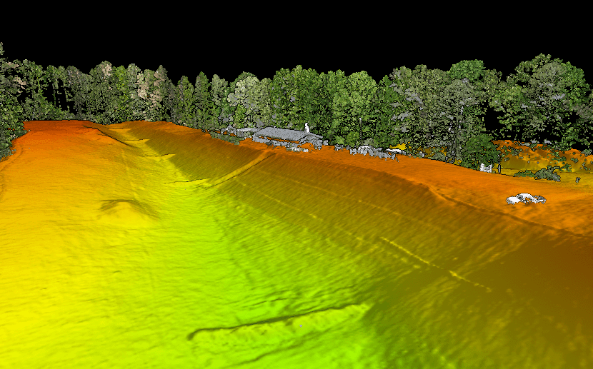
This recent addition to the course library establishes the necessary groundwork for basic point cloud workflows in Global Mapper. It progresses sequentially through the typical point cloud pipeline, from importing data to a final surface product deliverable.
After import, you’ll explore the vast visualization options for initial inspection of point cloud data in Global Mapper. Critical quality control workflows are included for comparing data against your surveyed control and rectifying common alignment issues. From there, dive into data management techniques like filtering different types of noise, cropping, and 3D thinning options to handle dense datasets efficiently.

The core of the training focuses on preparing data for analysis and specifically mastering the customizable settings in Global Mapper’s Automatic Noise and Ground Classification, which can be adjusted for different types of terrain. Then, convenient manual classification tools are demonstrated for refining results if needed. Lastly, you’ll create exportable terrain surfaces from the classified data by auto-identifying Model Key Points for TIN (Triangulated Irregular Network) surface generation, along with gridding options for creating raster Digital Terrain Models (DTMs).
Who should take this? This course is essential for land surveyors, civil engineers, and construction professionals who need to turn raw point clouds into reliable topographic surfaces for site planning.
For users ready to move beyond basic terrain creation and surface modeling, this new course focuses on custom feature identification, extracting vector intelligence, and working with large or specialty point cloud data.
The curriculum delves into specific automated workflows for three major categories: Buildings (extracting footprints and 3D roof planes), Utilities (extracting poles and lines), and Vegetation (extracting representative tree points and canopy coverage polygons). Beyond these standard tools, the course introduces advanced options, including how to refine segmentation settings and train a custom classification model. These tools help you identify non-standard objects in your data by teaching the software what to look for based on geometric properties.

Professionals keen to investigate multispectral lidar capabilities or combine bathymetric lidar and sonar in Global Mapper will find dedicated workflows and tips for working with these specialty data types. The course concludes with recommendations for processing large amounts of data, including a quick-start guide to scripting for simple automation of common point cloud routines in Global Mapper.
Unlike the linear progression of the Fundamentals course, this advanced course is designed with flexibility in mind. Because the topics cover distinct scenarios, users can browse and prioritize the lessons most applicable to their specific industry.
Who should take this? This training is highly technical and useful for professionals in forestry (canopy analysis), utilities (powerline corridor management), urban planning (3D city modeling), hydrography (coastal/riverbed mapping), agriculture (vegetation health monitoring) or anyone interested in fine-tuning custom feature classification and extraction.

Ready to start processing? Head over to the Blue Marble Geographics Online Classroom to enroll in these new courses and start earning your certificates today.
Discover our full range of premium learning resources:
