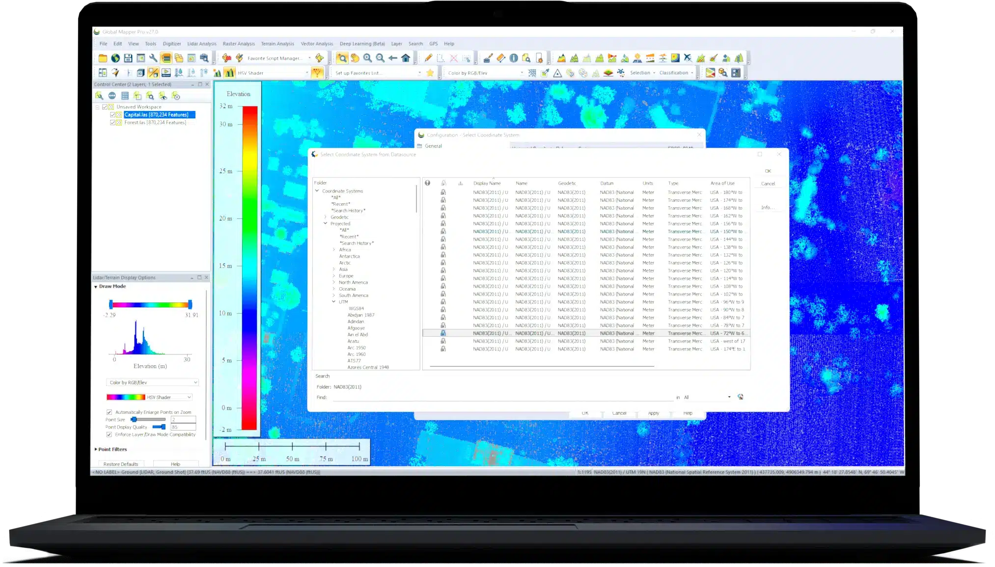
Trusted by GIS professionals around the world.
Global Mapper® is a cutting-edge GIS software that provides both novice and experienced geospatial professionals with a comprehensive array of spatial data processing tools, with access to an unparalleled variety of data formats.
Global Mapper’s intuitive user interface and logical layout help smooth the learning curve and ensure that users will be up-and-running in no time. Organizations of any size quickly see a significant return on investment brought about by efficient data processing, accurate map creation, and optimized spatial data management.
Developed for both GIS professionals and map enthusiasts, Global Mapper® has all the functionality you need in a GIS software:
One of the unique and defining characteristics of Global Mapper is its extensive and varied data format support. Offering direct access to over 300 raster, vector, and elevation data types, Global Mapper supports virtually all types of geospatial data right out of the box, no add-ons required. With new and modified formats being added on an ongoing basis, you can be sure that the software will never be out of date with your data.
Vector, raster, and elevation data can be exported in virtually every common file format as well as many proprietary types. During export, data can be tiled into smaller or more manageable files, or the export area can be cropped to a defined area or to the extent of the current screen view.
The new wireless direct data transfer capability allows the easy sharing of data, file exports, and feature templates from the desktop version of Global Mapper to Global Mapper Mobile, a mobile app, available on iOS and Android, for taking data into the field for reference and GPS-enabled data collection
Global Mapper’s online data function includes direct links to many of these data services including one-meter aerial imagery for the U.S., worldwide elevation data, topographic maps, Landsat satellite imagery, land cover data, the full Maine GIS catalog, aviation charts, OpenStreetMap vector data via WMS, and much more. Furthermore, if a local agency or organization develops a Web Mapping Service, a custom link to this data can be easily added to the online data source list. These web-based datasets can be either streamed in real-time or exported to a local file for offline use.
Through agreements with commercial data vendors, Global Mapper also offers fee-based access to premium spatial datasets. Using the Online Data function, you can download high-resolution imagery from DigitalGlobe, elevation data from Intermap, or US Land Parcel Data from Corelogic.
Global Mapper supports flexible raster data display, including contrast adjustment, support for multi-band data, pan sharpening, image tiling, and mosaicking with no need for additional modules.
Histogram Matching
Adding to the contrast adjustment options available for raster image data is Histogram Matching, which allows the color channel histograms of one layer to dictate the histogram adjustment in others. This process aids the blending of data layers collected at different times or with different equipment.
Raster Calculator
Allowing mathematical operations on multi-band imagery to extract different types of information, the Raster Calculator is found under the Analysis menu. Users can use predefined formulas, like NDVI and NDWI, or create their own free-hand formulas using common mathematical operations, like addition, subtraction, multiplication, division, and powers, as well as simple operators like absolute value, minimum value, and maximum value of two values.
Raster Reclassify
For the manual reclassification of any pixel-based data, the Raster Reclassify tool in Global Mapper assigns new values to pixels in a dataset based on user input rules defined by input and output values. Designed to work with imagery, palette, and elevation raster data, reclassification rule sets can be saved to use with multiple datasets for uniform reclassification.
Pan Sharpening
A commonly used raster enhancement process, pan sharpening uses a higher resolution panchromatic band of satellite collected data to increase the resolution of RGB imagery. Pan sharpening in Global Mapper supports multiple algorithms, including IHS, Brovey, ESRI Transform, and Simple Mean.
Tiling and Mosaicking
Both the tiling and mosaicking of data in Global Mapper can be completed during the export of data to a supported format. By default, a general Export command selected from the File Menu will include all displayed data, and each export options dialog contains a tab with options for data tiling.
The multi-view map display in Global Mapper® allows several docked map windows to be displayed within the interface for better data visualization and manipulation. These views, which support both top-down 2D rendering as well as oblique 3D viewing, can be independently zoomed and panned and can be resized to make the most efficient use of the available screen space.
As well as offering unrivaled access to pre-existing spatial datasets, Global Mapper provides a vast array of digitizing tools for creating and/or editing features on the map. As well as the standard point, line, and area creating functions, there are also tools for creating specialized geometric features such as range rings, grids, and buffer areas. Advanced coordinate geometry input can be employed to create objects on the map by simply typing the geometric dimensions of each segment.
Editing functions include rotating, scaling, and moving features on the map. Modifications can be applied to entire features or to individual vertices that determine the shape and size of a feature. Complex vector layer comparisons and feature creation can be performed with the Spatial Operations tool, which features Intersection, Union, Difference, and Symmetrical Difference operations, along with numerous spatial predicates and transforms. Global Mapper has full attribute and geometry editing capabilities rivaling any other GIS software on the market today. Combined with scripting and batching tools, it has the capability to automate many GIS processing tasks.
Global Mapper includes several powerful terrain analysis tools that are used to process or model elevation data. These functions are included as part of the standard installation and require no additional extensions or plug-in components.
When it comes time to share maps or data, Global Mapper offers many output choices.
Global Mapper is optimized to work with 3D data. It supports many 3D formats including elevation or terrain models as well as 3D mesh formats such as Collada, Wavefront, 3DS Max, and more. When working with terrain layers, several preconfigured shaders are available as well as the ability to create custom shaders. The software includes a powerful 3D Viewer which can be docked and linked to the 2D map so panning, zooming, and adding vector features will automatically replicate in both windows. This powerful functionality also includes the ability to select and measure features in the 3D viewer.
Global Mapper’s 3D functionality includes support for recording HD 3D fly-through videos, which provide a powerful way to visualize 3D projects for presentation and analysis purposes. The fly-through tool and also be used to playback a video file synced to any line feature with per-vertex times. The 3D window also allows draping of vector data over imagery, GPS tracking, Skyboxes for rendering a sky simulation in 3D, and display and manipulation of 3D meshes such as sketch-up. There are tools for selecting and editing 3D features and working with the 3D window, 2D window and the path profile in a docked set up enables complex analysis and 3D data manipulation.
Global Mapper is the perfect application for visualizing, editing, and analyzing Lidar or point cloud data of any format. Out of the box, the software supports point clouds of virtually any size and offers tools to utilize this data efficiently and effectively. Recent developments in the application have dramatically improved the rendering and processing speeds, which is especially important when working with the high-density point clouds that are becoming increasingly common. Global Mapper provides access to the attributes of the point cloud file offering a snapshot of the critical information that is essential for any data processing workflow.
For more advanced point cloud processing tools, Global Mapper Pro® offers an extensive array of functionality including automatic point classification, feature extraction, hydro-flattening, photogrammetric point cloud generation, and much more.
A standard function of Global Mapper is its ability to import virtually any image file and to create a geographically aligned and scaled raster layer. The image rectification process supports the manual input of image pixel and corresponding ground control coordinates or the simple tagging of recognizable points on the image as well as the corresponding locations on a base map layer. Advanced options allow the selection of the rectification method, resampling scheme, and ground control projection parameters.
The resulting raster layer can be analyzed and processed just like any other imported layer and can be exported in any one of the supported raster formats.
Global Mapper includes a powerful geocoding function that allows real-world coordinates to be assigned to an imported database of addresses. The geocoding process can use either a preconfigured online service or a user-imported road network to accurately determine the point that represents the location of each address. If necessary, this data, including the coordinate values, can be exported in tabular form or plotted on the map to provide a visual perspective.
Global Mapper includes numerous functions for processing imported data.
The Raster Calculator found under the Analysis menu is used to set up mathematical operations on multi-band imagery to extract different types of information. Users can use predefined formulas, like NDVI and NDWI, or create their own free-hand formulas using common mathematical operations, like addition, subtraction, multiplication, division, and powers, as well as simple operators like absolute value, minimum value, and maximum value of 2 values.
With a compatible GPS receiver attached to the computer, Global Mapper will display the location in real-time superimposed on the current map or data layer. Movement can be tracked or recorded, and waypoints can be created as time-stamped vector features. Track files can subsequently be played back using Global Mapper’s 3D fly-through visualization tool.
Many functions in Global Mapper can be performed by initiating a script. Formatted as a simple ASCII file, a script is commonly used to automate repeating or recurring tasks, eliminating the need to manually process the data. The Global Mapper scripting language supports importing, converting, reprojecting, analyzing, calculating attributes, splitting layers, interactively prompting users for files and folders and exporting all supported data formats.
Global Mapper supports reading and writing data from the most common spatial databases.
Using the Global Mapper SDK®, software developers can add functionality to the software by creating extensions. Examples of the use of extensions include extended format support, enhanced visualization options, or new toolbar buttons. An extension can also be used to provide an interface between Global Mapper and a third-party application. For more information on extensions, contact a Blue Marble sales representative (sales@bluemarblegeo.com).
For nearly three decades, Global Mapper’s development has depended on direct interaction with users and most of the major functional enhancements can be clearly traced to individual requests. This unique approach to software development has ensured that the application is continually updated and improved to ensure it is meeting the needs of today’s GIS professionals.
Learn more about the latest features here.
Features | Global Mapper | Global Mapper Pro |
---|---|---|
License Cost | $599 | $1,449 |
Support for importing and exporting 300+ file formats | ||
Access to online data sources for streaming imagery, basemaps, terrain, and vector data | ||
Vector drawing, editing, analysis, and spatial operations | ||
Attribute editing, joining, calculation, graphing, and querying | ||
Thematic and choropleth mapping | ||
Map design and pre-print layout | ||
Lidar display, filtering, and manual editing | ||
Terrain creation and modification | ||
Terrain analysis, including contour generation, line of sight, viewshed, watershed, and flood simulation | ||
Volume calculation, pile volume estimation, cut and fill analysis, and change detection | ||
Immersive 3D visualization, 3D data creation and editing, fly through recording, and layer animation | ||
Image rectification | ||
Image blending, feathering, cropping, and pan sharpening | ||
Image and raster reclassification | ||
Raster calculation Including NDVI, NDWI, NBR, and custom formulas | ||
Address geocoding | ||
Batch file conversion and workflow automation with Global Mapper scripts | ||
Integration with Global Mapper Mobile app | ||
GPS support for tracking and data collection | ||
Image blending, feathering, histogram matching, cropping and pan sharpening | ||
Terrain painting | ||
Breakline calculation | ||
Advanced querying, editing, segmenting, and filtering of lidar and 3D point clouds | ||
Automatic classification of point cloud data including ground, vegetation, buildings, power lines, and poles | ||
Vector feature extraction from classified point cloud data | ||
Lidar noise identification and removal | ||
Variography and Kriging | ||
Point cloud thinning and vertical and horizontal rectification of point cloud data | ||
Automatic alignment of overlapping point clouds | ||
Visual analysis of point cloud data, including by local density, height above ground, intensity, and classification | ||
Point cloud profiling | ||
Pixels to Points® - Drone/UAV imagery processing to create 3D point clouds, orthoimage, and 3D model | ||
Advanced automated vectorization of imagery and terrain | ||
Support for RTK devices and display of satellite constellation | ||
Built-in editor for Global Mapper scripts | ||
Support for Python scripting | ||
Script Builder tool to record actions in Global Mapper Script | ||
Streamlined mobile data merging |
Global Mapper Pro offers a complete set of GIS tools. The average cost of competing software starts at $4,000.00.