Global Mapper v27 Brings Geodetic Accuracy to Every Workflow

Go beyond analysis. Execute with confidence.

Global Mapper v27 integrates GeoCalc, Blue Marble’s industry-standard geodetic library, directly into the platform, so you can move from analysis to real-world execution with greater accuracy, speed, and reliability.


Geodetic Accuracy Without the Complexity

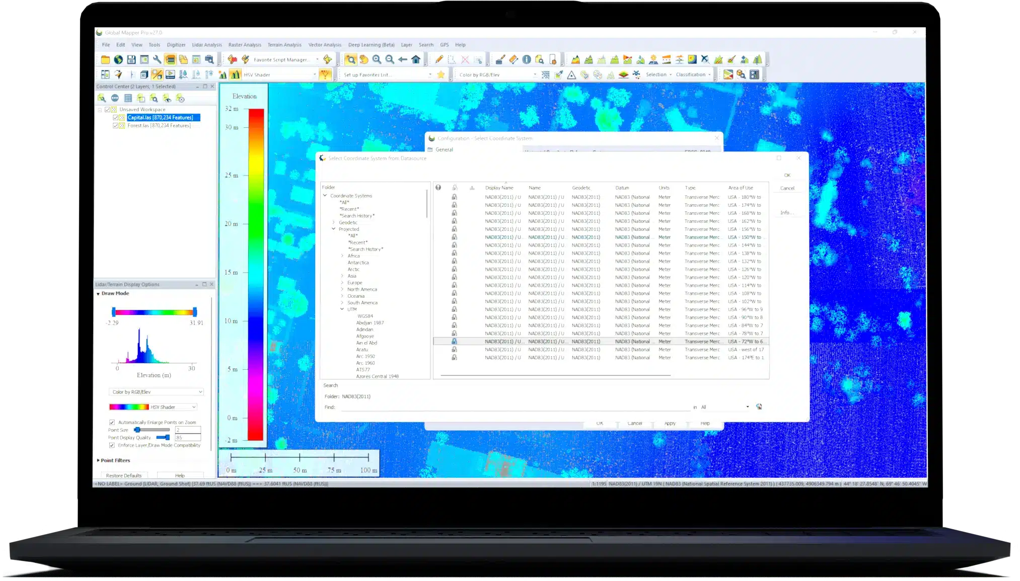
Global Mapper 27 streamlines desktop GIS and advanced geodetics by fully integrating GeoCalc, our industry-standard geodetic library. High-precision transformations that once required multiple systems can now be completed within a single workflow, reducing complexity and delivering more consistent, reliable results.

Validate Aerial Lidar With Confidence

Ensure positional accuracy from the start. Advanced horizontal quality assurance (QA) and positional adjustment tools align flight paths, improve point cloud accuracy, and support rigorous quality control (QC) standards required for UAS and government mapping programs.

Meet Evolving Data Standards Across Every Delivery

Built-in ASPRS density measurement methods help ensure compliance, reduce risk, and streamline validation across every delivery.

Optimize Breakline Creation With Intelligent Automation

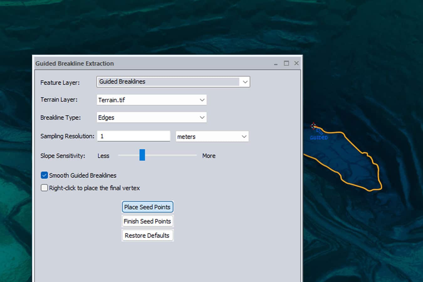
Replace manual digitizing with guided automation to enhance breakline creation and improve consistency and accuracy across terrain models.

Reduce Workflow Friction With Broader Format Support

Share point cloud data seamlessly with enhanced E57 export, leverage GPS time offsets with LAS 1.5 support, eliminate conversion steps with direct TFADS-O export, and integrate with GNSS workflows using GGF export.


Turn Highly Accurate Analysis into Real-World Execution

Accuracy

Ensure precise coordinate transformations and consistent data alignment with GeoCalc.

Integration

Complete more of your workflow in a single environment without relying on external tools or fragmented processes.

Execution

Deliver reliable results faster with validated, production-ready data.

Global Mapper v27 – Frequently Asked Questions

Q. Where can I find documentation on the new features? Angle right
A: The Knowledge Base has updated documentation on Global Mapper, including enhancements to the latest version. You can also view the free on demand course titled "Geodetics and Coordinate Management in Global Mapper" for a deeper dive on v27.
Q: Do I need a separate GeoCalc license to use the new functionality in Global Mapper? Angle right
A: No. In Global Mapper 27, the GeoCalc integration is a standard feature. It replaces the legacy projection engine, giving all users professional-grade precision without additional software.
Q: How does Guided Breakline Extraction improve my terrain models? Angle right
A: With Guided Breakline Extraction, you can initiate a feature, and the software will intelligently complete it based on the underlying terrain data. This ensures your Digital Terrain Models (DTMs) are both accurate and easy to produce.
Q: Does the new LAS 1.5 support affect my older lidar files? Angle right
A: Global Mapper 27 maintains full backward compatibility. You can still work with older LAS/LAZ versions, but you now have the added benefit of sub-second GPS time precision when working with the latest standards.

Companies using Blue Marble’s geospatial technology

United Nations
CDM Smith
Chevron Corporation
Amazon
Exxon
PepsiCo
NASA
BBC
Boeing
Harvard University