Designing Resilient Roads with Photogrammetry and Watershed Modeling
Java Island is home to nearly half of Indonesia’s population and the nation’s capital, Jakarta. While the northern coastline has long served as a hub for commerce and industrial development, including major ports and urban centers, the southern coast has remained largely rural. However, this region is characterized by volcanic landscapes, rugged mountains, and pristine beaches, making it an increasingly important destination for tourism.
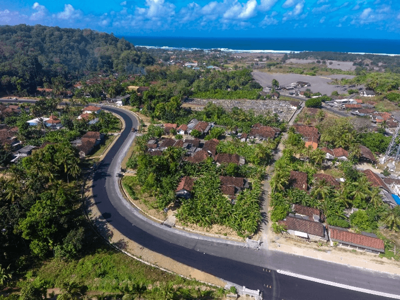
To support development within Indonesia’s National Tourism Strategic Areas, the government is developing the South Coast Road, officially known as Jalur Lintas Selatan Jawa. This major infrastructure project connects key cities such as Yogyakarta with airports and coastal tourist destinations along Java’s southern shoreline. By providing a safer and more direct route across the island, the completed road segments have reduced travel times from approximately seven hours to just two, thereby boosting tourism, increasing regional GDP, and contributing to poverty reduction.

PT Waskita Karya (Persero) Tbk is currently constructing a critical segment of this corridor, known as the Jalan Kretek–Girijati Road, which directly supports development within the Gunung Kidul National Tourism Strategic Area (KSPN). This route creates a more efficient transportation link between Yogyakarta International Airport, Adisutjipto Airport, Yogyakarta City, and popular southern coastal destinations. To ensure an environmentally responsible design and minimize disaster risk in this geologically complex region, Galih Yudha Wahyu Saputra and his team at Persero rely on Global Mapper® for photogrammetric processing and watershed analysis throughout the road planning and design process.
Infrastructure Risks
Infrastructure development along Java’s southern coast must be carefully harmonized with the surrounding natural environment. Steep terrain, highly variable elevation, and intense seasonal rainfall create inherent risks that, if not properly addressed, can lead to landslides, erosion, or flooding. Designing a roadway that works with existing topographic conditions is essential to long-term stability and safety.
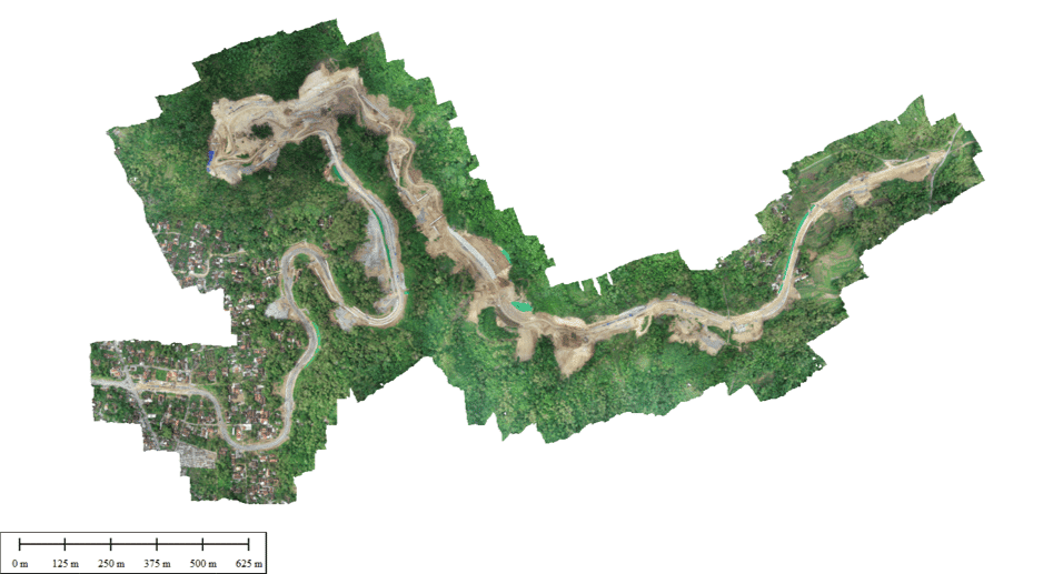
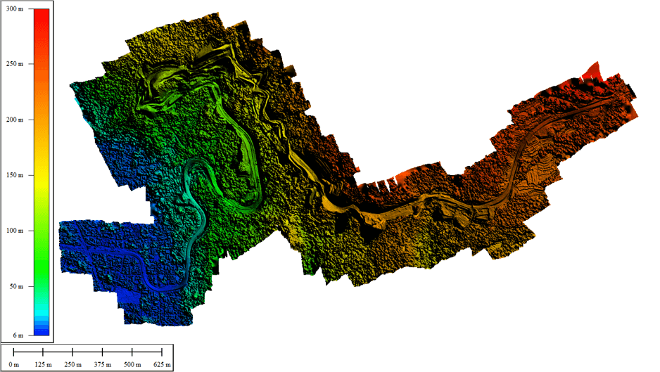
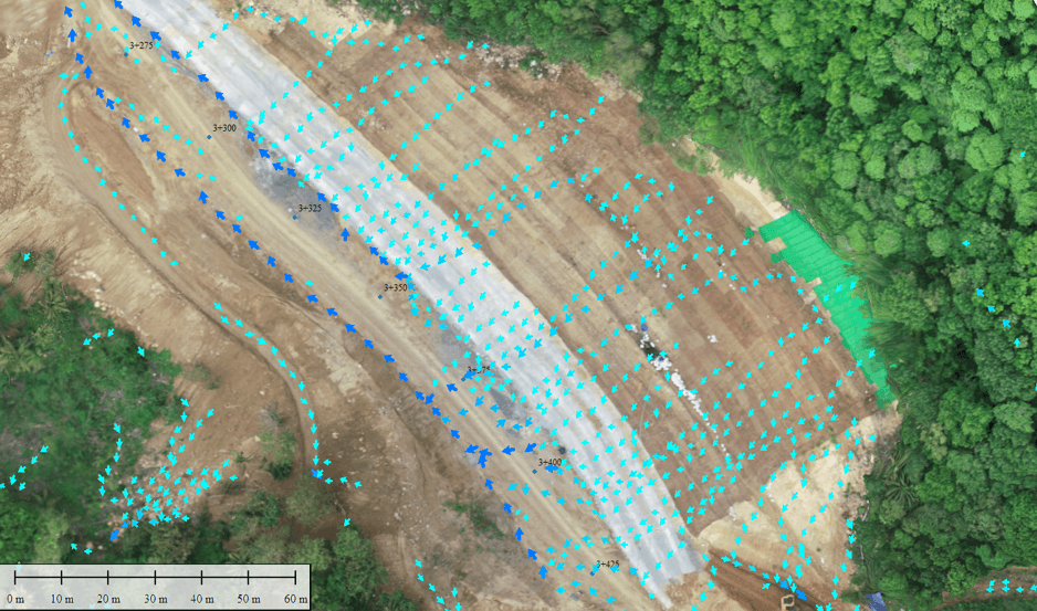
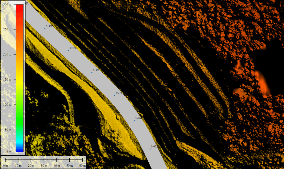
Geospatial analysis in Global Mapper plays a critical role in identifying and mitigating these risks. By analyzing elevation models, watershed boundaries, and surface flow paths, the project team gains a clear understanding of how water moves across the landscape and where it may concentrate during heavy rainfall events. Drone-collected imagery is integrated with terrain and hydrologic data to evaluate vulnerable areas and inform alignment, drainage, and earthwork decisions—helping reduce environmental impact while improving the resilience of the finished roadway.
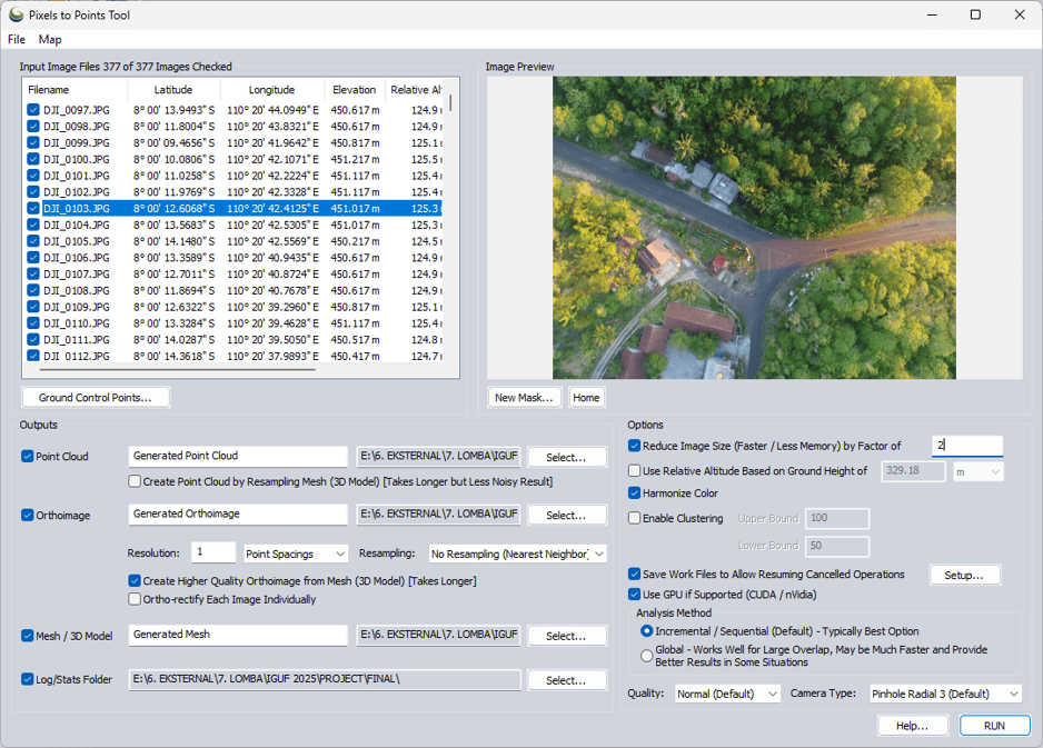
Photogrammetric Processing
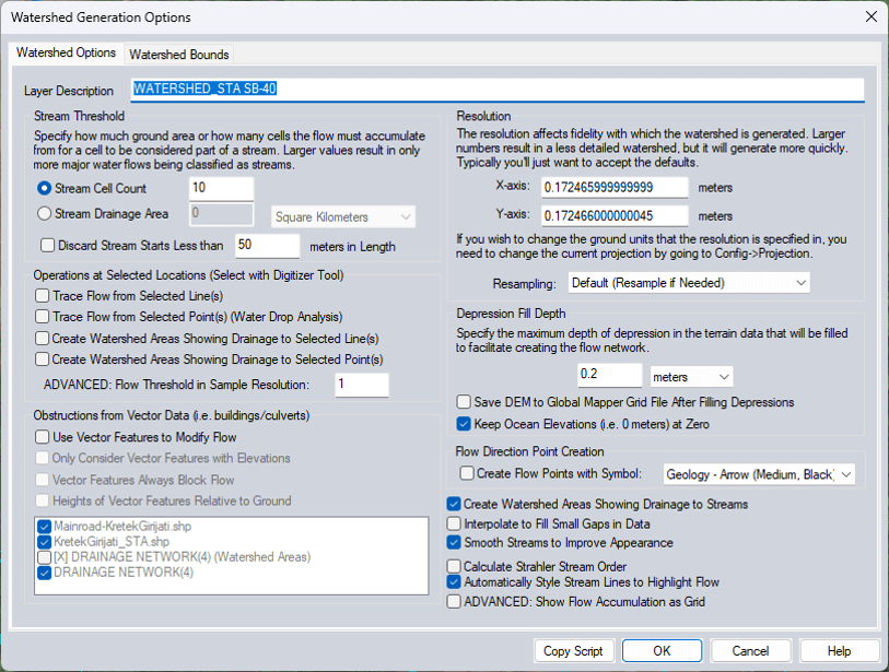
Watershed Analysis
Connecting to Web Map Services
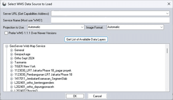
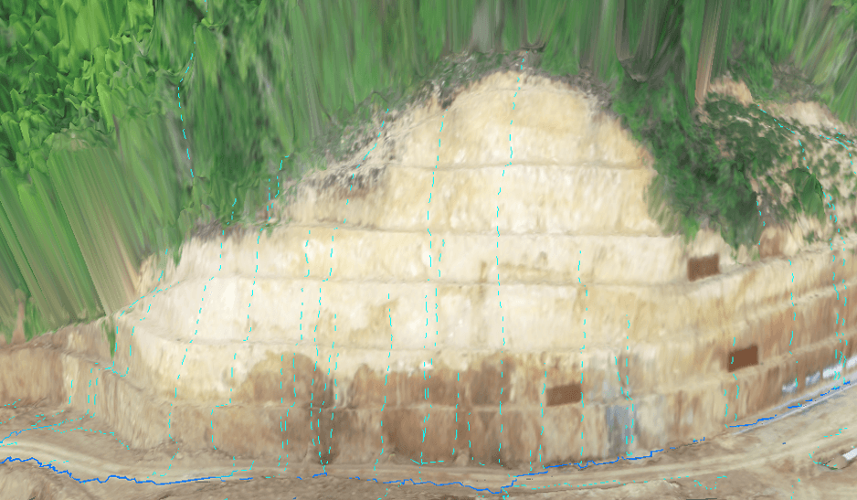
To further enrich the analysis, Global Mapper provides access to a wide range of data sources with the Online Data Sources tool, from publicly available lidar and satellite imagery to premium datasets. Additionally, within the tool, Add New Source allows users to connect to custom Web Map Services (WMS). PT Waskita Karya (Persero) Tbk maintains internal spatial datasets, including stationing points, road alignments, project boundaries, and right-of-way limits, which were published as a WMS and can be accessed through the Online Data tool. By adding this custom source, the project team was able to seamlessly overlay authoritative project data with terrain, imagery, and hydrologic outputs.
Overlaying and Visualizing Data
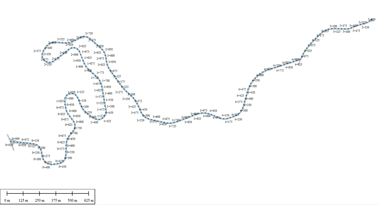
The final stage of the workflow brings all datasets together into a single, integrated environment. DEMs and orthophotos generated from Pixels to Points are overlaid with watershed flow paths and GIS layers accessed via WMS, revealing the relationships between terrain conditions, road design, and environmental risk factors. Using Global Mapper’s 2D and 3D visualization tools, the team can explore these interactions from multiple perspectives, supporting more informed decision-making throughout planning and construction.
Decision Making
The integrated overlay map produced through this workflow becomes a central reference for project planning and management. By visualizing terrain, hydrologic behavior, and design data together, the project team can quickly identify vulnerable points of the proposed road, such as steep slopes susceptible to landslides or areas prone to flooding and surface water pooling. These insights enable project managers to proactively adjust road geometry, drainage placement, and construction methods to avoid or mitigate risk before issues arise in the field.
Results
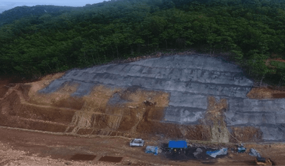
The photogrammetric and watershed analysis of the Jalan Kretek–Girijati Road corridor revealed multiple locations with a high potential for surface water accumulation. To validate the model, the team conducted ground observations during a significant rainfall event several days later. Field conditions confirmed the analysis, with water pooling occurring at the same locations identified in Global Mapper.
Armed with this information, the project team is able to implement preventative measures such as targeted drainage enhancements and slope stabilization efforts. These actions reduce the likelihood of landslides and flooding, while also protecting nearby communities and sensitive environments—supporting a more resilient, sustainable transportation corridor along Java’s southern coast.
By combining drone-based photogrammetry, watershed modeling, and integrated GIS data within a single environment, this workflow demonstrates how geospatial analysis can support more sustainable and resilient road construction. The approach used on the Jalan Kretek–Girijati Road provides a repeatable framework for infrastructure projects across Indonesia—helping engineers anticipate risk, reduce environmental impact, and make better-informed decisions throughout the project lifecycle.
This material is a product of the Indonesia Global Mapper User Forum (IGUF) 2025.
IGUF 2025 was held by PT. Geonet Infomedia, Blue Marble Geographics’ partner in Indonesia.
References
- A Widiana, and B S E Prakoso. “The Impact of Southern Cross Road (JJLS) Development on the Contribution of Regional Original Income (PAD) from the South Coast Tourism Sector in Bantul Regency 2014-2019.” IOP Conference Series Earth and Environmental Science, vol. 1039, no. 1, 1 Sept. 2022, pp. 012047–012047, https://doi.org/10.1088/1755-1315/1039/1/012047. Accessed 6 Jan. 2026.
- Centre, UNESCO World Heritage. “The Cosmological Axis of Yogyakarta and Its Historic Landmarks.” UNESCO World Heritage Centre, whc.unesco.org/en/list/1671/. Accessed 6 Jan. 2026.
- “ADB Supports Disaster-Resilient Road Development in Indonesia’s Southern Java.” Asian Development Bank, 3 Dec. 2025, www.adb.org/news/adb-supports-disaster-resilient-road-development-indonesia-southern-java. Accessed 6 Jan. 2026.
- Mowbray, Scott. “Never Heard of Yogyakarta? It Might Be the Center of the Universe.” New York Times, 20 Jan. 2025, www.nytimes.com/2025/01/20/travel/yogyakarta-indonesia.html. Accessed 6 Jan. 2026.
- Yesy Nadilla, and Maryunani. “Southern Coastal Road Construction and Inclusive Regional Economy in East Java.” Journal of Development Economic and Social Studies., vol. 4, no. 2, 5 Apr. 2025, pp. 411–425, https://doi.org/10.21776/jdess.2025.04.2.06. Accessed 6 Jan. 2026.
WORK MADE EASY WITH GLOBAL MAPPER

Want to try Global Mapper? Sign up for a 14-day free trial. You can also request a demo from one of our experts to see this workflow or other Global Mapper processing abilities.