

Introducing
Global Mapper Subscription
A new desktop offering that delivers more features for practitioners and more control for administrators.
Simpler administration for the whole team
Work that used to move through support queues and license spreadsheets now happens in one place, on your team’s schedule.
Included with every subscription, Blue Marble Hub is the new destination for practitioners and admins to manage their accounts. Sign in once across Blue Marble products. View your active licenses, reach support, and access the training library. No manual key tracking. No separate M&S contract to manage.
Unified login
SSO via Apple, Google, or Microsoft — one identity across all Blue Marble products.
License administration
Add and remove users, assign and revoke seats, provision co-administrators — no ticket required.
Offline & air-gapped access
Self-serve offline tokens for field crews and air-gapped deployments, issued directly from the Hub.
Support & training
Open support cases and reach the full training library from the same place you manage your account.
No one carries capabilities they don’t use, or the cost that comes with them.
Each named user gets the capabilities that match their role and workflow. When someone’s work grows, you simply upgrade them on Blue Marble Hub. Instead of a large upfront capital purchase, you pay a predictable annual operating cost: easier to get approved, simpler to forecast, and scalable to meet your needs.
Essentials
Starting at:
- Data viewing and format conversion
- Coordinate transformation and reprojection
- Access to streamed online data sources
Advanced
Starting at:
Everything in Essentials, plus:
- Terrain and vector analysis
- Scripting and workflow automation
- Advanced geodetic analysis
- Professional cartographic map production
Professional
Starting at:
Everything in Advanced, plus:
- Lidar and point cloud processing
- Drone photogrammetry
- Complex imagery and raster analysis
- Automated breakline extraction
- AI/ML image classification
Compare features – Global Mapper
Essentials
Starting at $599/yr
Advanced
Starting at $1,199/yr
Professional
Starting at $2,199/yr
The latest capabilities on every seat, without the administrative overhead
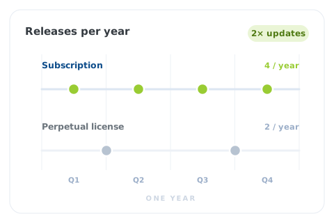
Subscription ships four releases each year: 2x the updates of the perpetual license model.
Each future release will bring even more specialized capabilities to Global Mapper, so your GIS teams can do more without adding more software to the tech stack.
A complete GIS desktop workflow in one subscription
Global Mapper Subscription brings together previously separate products into a single workflow that takes you from raw data to quality deliverable.
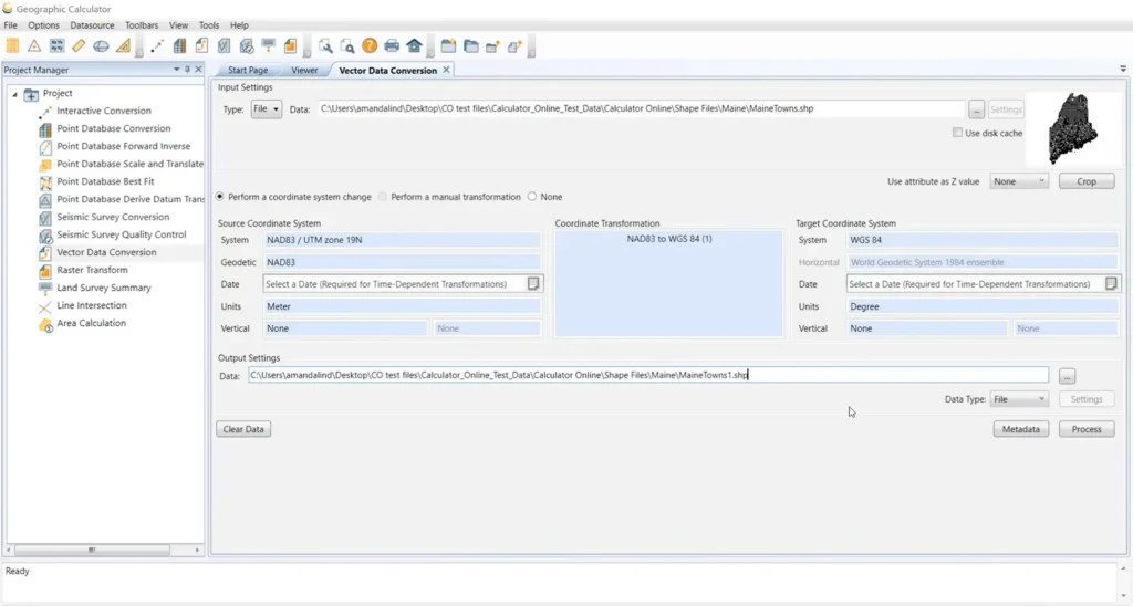
Geographic Calculator
Primary role
Conversions & transformations
Core capability
Transform local custom coordinates to a geodetic or projected system
Target output
Data in well-known coordinate systems
The goal
Make data compatible across data layers
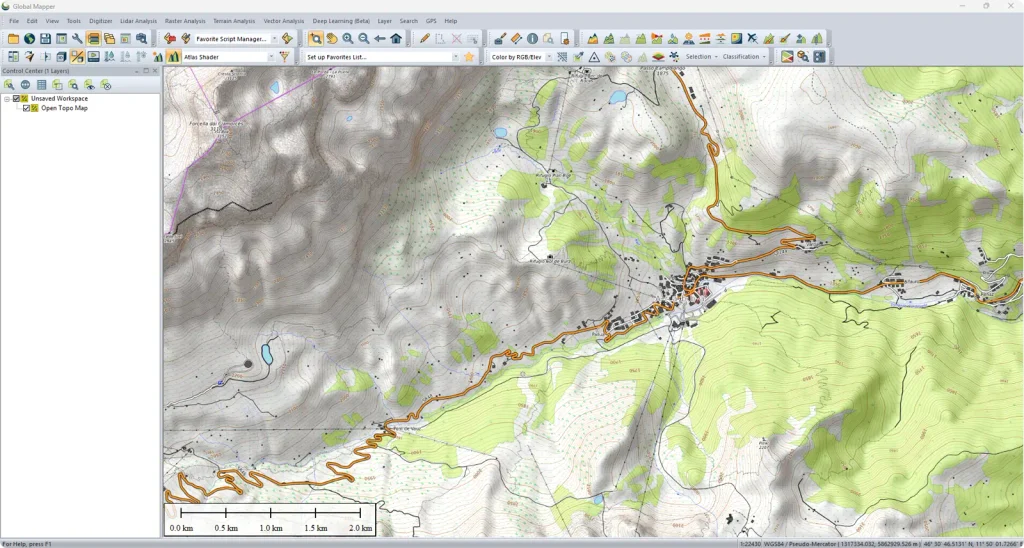
Global Mapper
Primary role
Data prep & analysis
Core capability
Combine data from multiple sources & types, vector editing, data analysis
Target output
Optimized & highly manageable vectors
The goal
Make data meaningful
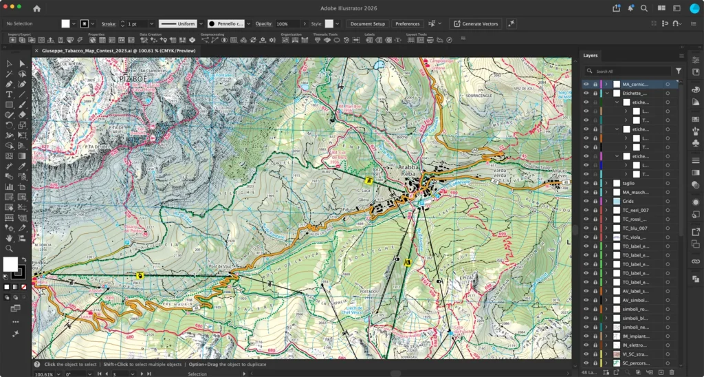
MAPublisher
Primary role
Cartographic design & publishing
Core capability
Adobe Illustrator integration, CMYK print styling, and automated map themes
Target output
Polished & authoritative visual maps
The goal
Make data easy to act on
Plus, new Global Mapper
features only on subscription
ESSENTIALS
Industry leading geodetics engine
Transform data with confidence. Support for 2D and 3D systems, including vertical CRS and time-dependent datum handling, delivering accurate geodetics across every workflow.
ADVANCED
Visual fidelity across the workflow
Exchange GeoPackage files without losing symbology, feature classification, labeling, or applied styles. Ensure data looks the same in Global Mapper as it does in third-party applications without manual clean up.
ADVANCED
New import & streaming sources
Reduce tool-switching by connecting ESRI MapServer raster and ImageServer directly to Global Mapper. Access thousands of datasets without downloading tiles or working through a separate GIS client.
ADVANCED
Embedded advanced geodetics tools
Run datum transformations and horizontal time-dependent positioning at any stage of your workflow, without switching applications or managing a separate license.
PROFESSIONAL
Automated tree trunk classification
Apply ML-powered classification to identify individual tree trunks directly from lidar point clouds. Purpose-built for forestry, urban planning, and vegetation management workflows, you now get reliable trunk inventories without manual digitizing.
PROFESSIONAL
Live preview window in point cloud analysis
Shorten the tuning loop from minutes to seconds with a real-time preview pane in the Automatic Point Cloud Analysis tool. Evaluate how parameter changes will affect the output without committing to a full run, reducing processing time and trial-and-error approaches to unfamiliar datasets.
PROFESSIONAL
Multi-spectral imagery support
Complete full photogrammetry workflows inside Global Mapper without a separate application. Deliver band-separated outputs to clients or downstream analysis tools in a single processing pass.
PROFESSIONAL
Faster photogrammetric -processing
Spend less time processing large datasets and complex scenes. Denser and more complete mesh outputs on complex terrain and vegetated areas achieve higher quality without a hardware upgrade.
These capabilities are available exclusively to subscribers. Existing perpetual licenses continue to run on the version they have.


