3D View
Accessed through the main menu, the 3D Viewer displays 3D vector, raster, and point cloud data in a true perspective 3D manner.
 This feature requires a Pro license
This feature is only available on iOS devices
Use touch and drag movements to zoom in, zoom out, rotate and move the data within the viewer. Press OK to close the 3D Viewer.
This feature is especially useful for viewing collected lidar scans.
For additional 3D Viewer capabilities, load the data into Global Mapper Desktop.
3D View Buttons
![]() Home - when pressed, this button zooms the map to the full extent of the loaded data, returning the 3D View to its default state based on the data present.
Home - when pressed, this button zooms the map to the full extent of the loaded data, returning the 3D View to its default state based on the data present.
 Show/Hide Layers - Choose which layers to turn off from the display. They will not be unloaded from the map. Changes will also affect the 2D view.
 Configuration:Settings and Display Options for the 3D Viewer, listed below. Some settings will also effect the 2D view.
 Configuration Settings - Display Options
GENERAL
These settings can also be found in main Configuration menu, in the Display Tab.
Show Terrain Surface - Uncheck this option to turn off elevation grid layers from display in the 3D View.
Show Imagery - Uncheck this option to turn off image layers from display in the 3D View.
Show Vector Features - Uncheck this option to turn off vector layers from display in the 3D View.
Show Lidar Features - Uncheck this option to turn off lidar layers from display in the 3D View.
Vertical Exaggeration - This value determines the amount of exaggeration applied to 3D data in the 3D view.
The value is a multiple of the actual elevation. A value of "2" is twice as exaggerated as the original values.
Field of View - The Field of View is a degree measurement that defines how wide of a view the camera has in 3D. The default field of view is 60 degrees.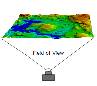
Background Color - Specify the background color used in the 3D view.
LIDAR
Lidar Draw Mode - Lidar or point cloud data can be colored using one of two point attributes. Draw options include:
-
Point Color - Colors the points by Red, Green, Blue (RGB) values.
-
Elevation - Applies a color spread to the range of elevations found in the Lidar data.
SHADER
Shaders apply color to an elevation layer. These settings are mirrored in the main Configuration Menu: More > Shader.
-
Shader Name - Select the shader used to display loaded elevation data.
-
 Available Shaders
- The Atlas Shader is the default shader. Like many other shader options the color ramp will scale to the data range.
- The Color Ramp Shader displays a ramp from blue for the low elevations to red for the highest elevations.
- The Daylight Shader colors all elevations the same and is only useful when hill shading is enabled.
- The Global Shader uses fixed elevation values so elevations will be colored the same from map to map. This shader is designed for datasets covering large areas.
- The Gradient Shader uses a gray scale to color the elevation with lower elevation values colored darker than higher values.
- The HSV Shader maps the elevations onto the HSV (hue saturation value) color space.
- The NDVI Shader (Normalized Difference Vegetation Index) is used for layers with the NDVI calculation applied.
- The NDWI Shader (Normalized Difference Water Index) is used for layers with the NDWI calculation applied.
- The Slope Shader displays loaded elevation data by slope rather than elevation using a gray scale shader. This shader allows you to identify areas that are flat versus those that are steep.
- The Slope Direction Shader colors loaded elevation data by the direction in which the terrain faces. This shader uses green for north, blue for east, red for south, and white for west.
- The Inferno Shader is useful for visualizing data in the style of a heat map. Similar to the Viridis Shader, it is useful for printing in black and white, or for users with colorblindness.
- The Magma Shader covers a wide perceptual range in brightness and purple-yellow. Similar to the Viridis Shader, it is useful for printing in black and white, or for users with colorblindness.
- The Plasma Shader is another color option similar to the Viridis Shader. This color palette is useful for printing in black and white, or for users with colorblindness.
- The Viridis Shader covers a wide perceptual range in blue-yellow, and does not rely as much on red-green contrast. This color palette is useful for printing in black and white, or for users with colorblindness.
- The REM Shader is designed to highlight trends at the lowest elevation of the data. Enabled by default when generating REM layers.
-
-
Enable Hill Shading - Enable hill shading to show loaded elevation data shaded with relief. With this option off, elevation data appears flat with elevations shown only with the set shader.
-
Display Water Level - Enable to display water on loaded elevation layers.
RESET
-
Restore Defaults - Return all configuration settings to their original state.