Lidar
Global Mapper Mobile provides tools for users to scan discrete objects using the lidar cameras built into some iOS devices. These scans can be viewed in Mobile's 2D and 3D viewers, and exported to Global Mapper Desktop.
Lidar is a remote sensing technology that uses light to collect 3D point cloud models of objects. Point clouds are detailed representations of the collected object that can be used for future reference, measurements, and more. Lidar point clouds generated through Global Mapper Mobile can be viewed in the mobile 3D viewer, exported to common lidar file types, or transferred to be used in Global Mapper desktop.
To collect lidar, click Lidar from the Main Menu then click New scan from the bottom right corner.
 This tool requires a Pro license
This feature is only available on iOS devices
Collecting lidar in Global Mapper Mobile:
-
Choose Lidar from the Main Menu. This will bring you to the Lidar Scans Menu Page.
-
Choose New Scan from the bottom of the page.
-
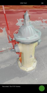
Hold the sensor in front of the object to be scanned.
-
Touch the Red button to begin recording. The circle will turn Green while recording.
-
Regions that still need to be scanned will be highlighted in red as you move around the object.
-
-
Touch the Green button to pause the current recording.
-
Touch OK to finish the scan, returning you to the Lidar Scans Menu Page. The new collection will appear at the top of the list.
-
Click Process to view or export the data.
View Scanned data in the 3D Viewer, accessed from the Main Menu.
Lidar Scans Menu Page
Opening the Lidar function in Global Mapper Mobile will bring you to the Lidar Scans Menu Page, which provides access to previous scans, and the option to start a New Scan.
Click OK to close the page.
 Sort Order:
Choose to sort the listed lidar files alphabetically by file name, or by the time they were created.
 Options
Tap the vertical dots to the right of the package name to open lidar metadata, including creation date, location bounds, and projection.
New Scan:
Click New Scan to open the scanning tool. See the Collecting lidar in Global Mapper Mobile section above for steps, and the Tips for Scanning section below.
Regions that don't have enough scan data for model building will be highlighted in red as you move around the object.
During data collection, GMM will continuously generate frames containing depth and camera image data. The more frames will be create, the more data you will have in the model.
Tips for Scanning:
-
Move slowly when capturing the object.
-
Maintain the angle of the scanning device relative to the ground during the scan. (If you start with your phone perpendicular to the ground, keep it that way.)
-
Keep the device at a similar distance from the object.
-
Press the green button to pause the scan when moving the device to scan from a different angle.
Lidar Layer Options:
Process - Create a point cloud from the scanned data.
Rename - Rename the scan. This name will be retained during export.
Delete - Delete the scan. Note - deleting a scan is permanent.
Create Point Cloud Options
Use this menu to process the scanned data into a useable point cloud. The point cloud can be exported to a file for future use, loaded into the map viewer, or both.
To open previously exported files in Global Mapper mobile, use Main Menu > Add Layer(s) from File.
To export files from the map viewer to Global Mapper desktop, use the Main menu > Save/Export Map to File options, or desktop's Mobile Data Manager.
General
Create Map layer - automatically load the layer in the 2D view window after processing.
Delete Scan Data On Success - deletes the scanned data from the lidar scans menu page.
Export
Exported files are saved in the current map folder. To open previously exported files in Global Mapper mobile, use Main Menu > Add Layer(s) from File.
None - load the layer in the workspace without generating an export file. If the layer is closed in the workspace, it will need to be reprocessed before it can be viewed again. Loaded lidar layers can be exported to a file using Main Menu > Save Map to File.
Lidar LAS (.las) or Lidar LASzip(.laz) - . LAS is typically the best option. It is the most common file type for lidar, and contains all associated attribute and projection information. If the exported file will be large, consider choosing the compressed version: LASzip (.laz).
PLY (ASCII Point Cloud Lat/Long) - exports as a text file. This format is commonly compatible with non-GIS software. Note that the text file formats do not inherently contain projection information. You will want to note the file's projection for future reference.