Vertical Transformation Methods
The Geographic Calculator supports transformation between vertical coordinate systems. These models are largely based on grid tables and are not easily implemented by the end-user. If you require a particular vertical model that is not supported, please contact Technical Support to request the model.
To perform a vertical transformation, your coordinate system must have a Vertical assigned to it in the Vertical field of the Coordinate System definition panel.
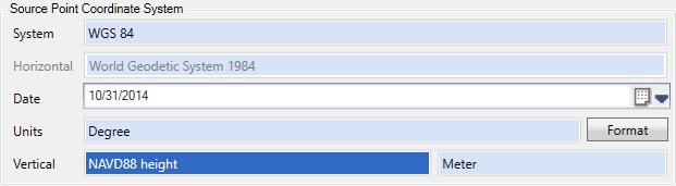
This Vertical Coordinate System includes a complete definition for the vertical components of your data, and is based upon a Vertical Datum. A Vertical Datum represents a frame of reference for making height measurements within a coordinate system.
With Verticals selected for both your Input and Output Coordinate System, you will be prompted to choose an appropriate Vertical Transformation when Selecting a Coordinate Transformation.
The Ellipsoidal Height Vertical Reference is a special case which bases heights relative to the horizontal coordinate system's ellipsoid, and thus specifies neither a Height Model nor a Vertical Datum.
For more information on vertical transformations, please see:
Note: When browsing through
the datasource, some objects may be flagged with a red exclamation point
![]() symbol. These objects are incomplete definitions.
The Geographic Calculator includes a number of object definitions
that require supplementary data files to function properly. These
objects cannot be used until the supplementary files are added. Some
of these are available at our website (https://www.bluemarblegeo.com),
while others are proprietary and must be purchased from a specific government
agency.
symbol. These objects are incomplete definitions.
The Geographic Calculator includes a number of object definitions
that require supplementary data files to function properly. These
objects cannot be used until the supplementary files are added. Some
of these are available at our website (https://www.bluemarblegeo.com),
while others are proprietary and must be purchased from a specific government
agency.