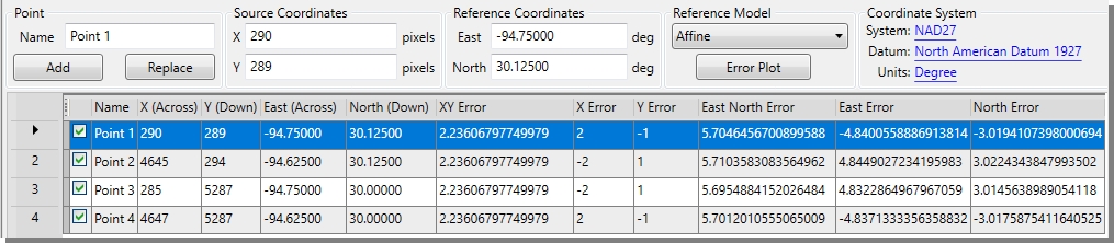
Reference Point List
The Reference Point List displays the list of reference points that have been defined for the current source image. It also includes all residual error information for each individual point.
Adding a Reference Point
To add a reference point to the list, specify a Point Name, the Source X and Y pixel values (manually or using the Source Image Viewer), and the Reference East and North coordinate values (manually or using the Reference Image Viewer). Once all values have been specified, click the Add button and the point will be added to the bottom of the list.
Modifying the Reference Point List
- To include/exclude an existing point from the referencing solution, check/uncheck the checkbox on the left of the desired point.
- To modify an existing point, select that point in the list, change any of the point values (name, Source X or Y, Reference East or North) and click the Replace button.
- To delete an existing point, right-click on that point in the list and select Delete Reference Point from the popup menu.
- To delete all existing points, right-click anywhere on the Reference Point List and select Clear Grid from the popup menu.
Referencing Model
A georeferencing solution will be calculated based on the selected Referencing Model as you add, delete, include or exclude reference points. Each Referencing Model has important properties and should be applied appropriately.
The available Referencing Models are:
- Affine: Incorporates a single scale change, a rotation, and two translations to transform unknown coordinates from one arbitrary system to coordinates in another system given the values of known reference points. A minimum of three reference points must be defined and included in order to compute an Affine solution. This solution type should generally be applied when referencing large-scale maps (1:50,000 or less) published in a nearly rectilinear map projection such as the Mercator or Transverse Mercator.
- 1st Order Polynomial: Requires 4 reference points
- 2nd Order Polynomial: Requires 6 reference points
- 3rd Order Polynomial: Requires 10 reference points
- 4th Order Polynomial: Requires 15 reference points
- 5th Order Polynomial: Requires 21 reference points
Coordinate System
All Reference Points for an image must use the same Reference Coordinate System. The currently selected Reference Coordinate System’s name, datum, and units are displayed in the coordinate system section. Clicking on the Coordinate System button will allow you to Change the Reference Coordinate System.
Residual Errors
Once you have added enough points to compute a georeferencing solution, residual errors for each reference point are calculated. A residual error is the computed difference between an observed source coordinate and a calculated source coordinate as the result of the transformation. A large residual error indicates possible error in either the observed source coordinates or the reference coordinates of the reference point in question.
As a general rule, you should apply several different Referencing Models and include/ exclude questionable points. Select the model and reference points that yield the minimum residual error, assuming that you have defined the reference points correctly.
In addition to the errors listed in the Reference Point List, a graphical representation of the errors is available by clicking the Error Plot button below the Referencing Model drop-down, or from the Georeferencer’s View>Error Plot menu item.