DLS Descriptions
When converting DLS coordinates, users should set the DLS Descriptions, which includes several options. The format for input and output coordinates can be set by clicking the Format button in the Coordinate System area. Click the DLS Descriptions panel to access the DLS Format settings.
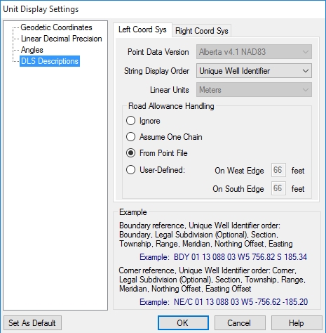
Note that there are separate tabs for the Left Coordinate System and the Right Coordinate System. This allows users to convert from one DLS format to another. Set the format for input coordinates on the Left Coordinate System tab, and set the format for output coordinates on the Right Coordinate System tab.
Point Data Version: The Geographic Calculator allows conversion to and from any of the standard ATS versions from version 2.1 through version 4.1, if you have the appropriate shift files. The files for ATS version 4.1 are available for download from the Blue Marble website. Download and run ATS4.1ShiftFiles.exe to automatically install the shift files in the default data path. Earlier versions of ATS must be obtained from another source, and placed in the Geographic Calculator data path. The default datasource location is:
C:\Program Files\Blue Marble Geo\Geographic Calculator\Data\shiftfiles
This location can be changed in the General Preferences dialog. Shift files from earlier DLS (ATS) versions are available from AltaLIS at http://www.altalis.com/contactus.html
String Display Order: There are two different orderings used for the string display order of DLS coordinates: Standard Survey and Unique Well Identifier. The example area below the selection fields will display descriptions and examples of the currently chosen ordering.
Linear Units: Offsets from the Section Corners or Section Boundaries can be measured in either International Feet or Meters.
Road Allowance Handling: This area allows you to specify how to calculate the road allowance between sections. You can select to use no road allowances, one chain for all road allowances, or the allowances specified in the DLS point file. You also have the option of defining custom road allowances.
The Set as Default button will take the settings that you have selected for the Left Coordinate System and apply them to both the left and the right side when you create a new job with one of the DLS coordinate systems. The default settings may be viewed when the Unit Display Settings dialog is launched from inside the General panel of the Preferences form.