General Preferences
This tab allows you to adjust a number of general settings related to workspaces, the geodetic datasource and basic conversions.
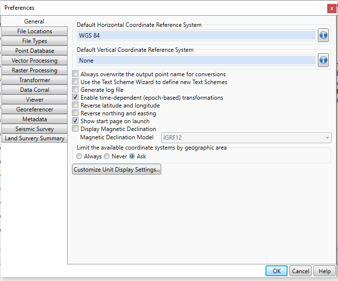
The Default
Horizontal Coordinate Reference System is used as the default for
any Horizontal Coordinate Reference System field that is unpopulated.
The Default Vertical Coordinate Reference System is used as the default for any Horizontal Vertical Reference System field that is unpopulated.
Options
Checking the Always overwrite the output point name for conversions option will overwrite the point name on your output point for Interactive conversions.
Checking the Use the Text Scheme Wizard to define new Text Schemes option will automatically open the Text Scheme Wizard when you select Options > Text File Schemes. When unchecked, the Text File Scheme option will open the Text Scheme Edit form.
Checking the Generate Log File option will generate a log file of your conversions in your system folder, named Calculator.log.
Checking the Enable time-dependent (epoch-based) transformations option will turn on the Time-Dependent Transformations functionality.
Checking the Display Popup hints option will show short feature descriptions when the mouse is hovered over buttons.
Checking the Reverse latitude and longitude option will change the display order for latitude and longitude in the Interactive Conversion job and the Point Database Conversion job.
Checking the Reverse
northing and easting option will change the display order for northing
and easting in the Interactive Conversion job and the Point Database Conversion
job.
Magnetic Declination
The Display Magnetic Declination will add a field with magnetic north to all Point Database Conversion and Interactive Conversion jobs. Use the drop down menu below to select the Magnetic Declination Model. Available Magnetic Declination Models include: IGRF11, IGRF12, WMM2010, WMM2015, and GUFM1. By default, the latest generation of the IGRF model will be used as it has the greatest valid date range.
GUFM1
This model covers the time period from 1590 to 1990, but is typically not used for dates more recent than 1900.
Four centuries of geomagnetic secular variation from historical records. Jackson, A., Jonkers, A. R. T. and Walker, M. R. Phil. Trans. Roy. Soc. A (2000) Vol. 358, pp957-990.
International Geomagnetic Reference Field (IGRF)
IGRF11 - This model covers the time period from 1900 to 2010, and uses a dataset format similar, but not identical to, the ones used with the World Magnetic Model.
IGRF12 - This model covers the time period from 2015 to 2020.
For more information see https://www.ngdc.noaa.gov/IAGA/vmod/igrf.html
World Magnetic Model (WMM)
WMM10 - returns the declination angle at given a 3-dimensional geodetic point and time. The valid times are between 2010 and 2014.
WMM15 - The new World Magnetic Model, covering the time period of 2015 to 2020.
For more information see https://www.ngdc.noaa.gov/geomag/WMM/
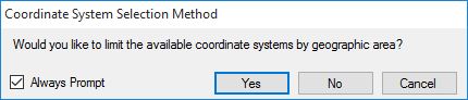
Limit the available coordinate systems by geographic area
Choosing Always will open a window before each coordinate system selection that allows you to limit the coordinate systems by a point or area of your choice.
Choosing Never will take you to the Select Coordinate System from Datasource window with all available coordinate systems available (unless otherwise filtered)
Choosing Ask will prompt you before each coordinate system selection if you would like to limit the coordinate systems by area, or if you would like to select from all available coordinate systems.
Customize Unit Display Settings
Clicking the Customize Unit Display Settings... button will open the Unit Display Settings window, which allows you to set the format of your coordinate data for all windows of the Geographic Calculator.