File Location Preferences
This tab allows you to choose where the workspace files are located, and where the system will look for vector and raster data files.
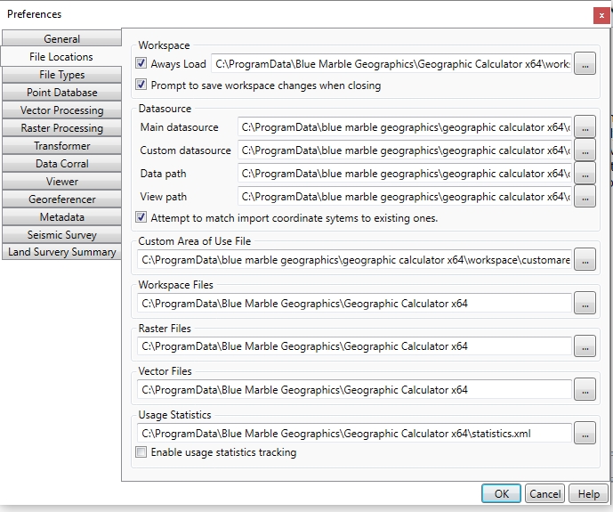
Workspace
The Workspace region allows you to specify the default workspace, and to set whether you want to be prompted to save workspace changes when the Calculator is closed.
Always Load- check this option to load the default workspace specified to the right every time Geographic Calculator is launched from windows.
Prompt to save workspace changes when closing - Any changes made to the workspace will produce a save dialog before the workspace is closed. This includes changes to jobs inside of the workspace.
Datasource
The Datasource region allows you to specify the base datasource, custom datasource objects and views, as well as the directory containing grid shift files.
Main Datasource - The main geocalc datasource file
Custom Datasource - Any custom objects added to the datasource are specified in the custom datasource file, typcially custom.xml . To share custom datasource definitions between machines and users, this file may be shared or imported.
Data Path - Any supporting datasource files, such as shift files and custom geoids will be located in the data path folder.
View Path - The view file specifies the datasource organization for any new workspaces that are created. This may be overridden by Administrative Settings for Filtering or locking the view file.
Checking Attempt to match imported coordinate systems to existing ones will mean that when importing coordinate systems from WKT/PRJ or dragging and dropping PRJ files onto the Coordinate System controls, the Calculator will try to find a match for the imported system in the geodetic datasource.
Custom Area of Use
Custom Area of Use File specifies the path to theCustom Areas of Use.
Default Data Folders
The Workspace Files field allows you to specify the default location for Workspace files.
The Raster Files field allows you to specify the default location for Raster files. This is the default path when specifying data for raster transform, Georeferencer, etc.
The Vector Files field allows you to specify the default location for Vector files. This is the default file path navigated to when loading vector data.
Usage Statistics
The Usage Statistics option allows you to specify the default location for saving your useage statistics and allows you to toggle tracking on and off.