Least Cost Path Analysis
The Least Cost Path Analysis tool finds the best route between specified locations across a terrain layer based on minimized terrain slope angle. Avoid problematic or undesirable areas by using slope, elevation, or area feature constraints. The resulting path is generated as a line layer in the workspace. Locations can be specified by importing a previously loaded point layer, or by choosing points on the map from within the tool.
|
|
This tool requires Global Mapper Pro |
This tool can be found in the Terran Analysis Menu.
Download (export) Online Data sources to make them compatible with this tool.
Path Builder
The Path Builder contains the list of points to be connected by the least cost path. Add points to the builder by using the buttons below. Double-click on a listed point to automatically center the workspace on the feature.
Depending on your chosen Path Order, the order of points in this window may affect the generated output. Drag and drop to reorder the points.
Add Selected Point(s) - Imports point features that are currently selected in the workspace.
Add Point Layer(s) - Imports points from chosen layers loaded in the workspace.
Add Point Location - Specify a point location from the map, or from input coordinates. Points specified from the map will be symbolized in the workspace as a white star.
Remove Point - Removes the selected point feature(s) from the list.
Path Order
Specifies how to order the points in the generated path(s):
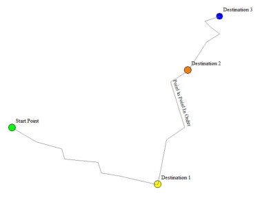
From start to each destination in sequential order - Creates a path through the points in order from the first point to the last in the Path Builder.
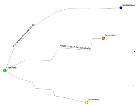
From start to each destination separately - Creates a separate path from the first point to each additional point.
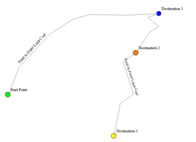
From start to each destination at least cost - Finds the most efficient path starting at the first point in the list and passing through every other point.
Avoid Settings
Avoid transecting area features, certain elevations, or slopes of a specified threshold.
Avoid slopes outside of the range - Set the minimum and maximum slope tolerance for the path to take.
Avoid elevations below - the minimum elevation that a path is allowed to travel at.
Avoid elevations above - the maximum elevation that a path is allowed to travel at.
Avoid areas from selected layers - select area features in the workspace to use this option.
Cost Settings
Slope Cost Multiplier - multiplier to apply to the slope-based cost along a segment. Larger values will cause steeper slopes to be more costly and thus avoided more.
Slope Change Cost Multiplier - multiplier to apply to the change in slope between two segments. Larger values will cause larger changes in slope to be more costly and thus avoided more
Options
Layer Description - Name of the layer that the path lines will be added to.
Combine multiple paths into a single line feature - specifies that the generated path through the points should be made a single line feature rather than a separate line feature for each sub-path.
Simplify Generated Path(s) - specifies the 2D simplification threshold to apply to the generated path lines. If not specified, no simplification is done.
Smooth generated paths - enable this option to smooth the generated path features.
Sample Spacing
Sample Spacing - specifies spatial resolution to sample the terrain layer(s) at. Defaults to the minimum spatial resolution of the layers
Resampling - specifies the sampling method to use when resampling the terrain layer(s). Choose a resampling method. For more information on methods, see Convolution Filters.
Scripting: See FIND_PATH