The Manage GPS Vessels command will display the Manage GPS Devices dialog (pictured below). This dialog displays a list of all GPS devices that are currently being tracked and provides the ability to modify several settings related to the GPS devices, such as device icon and track style, allowed boundary, etc. This dialog can be considered the central command center for fleet management operations when tracking multiple GPS devices through a compatible receiver.
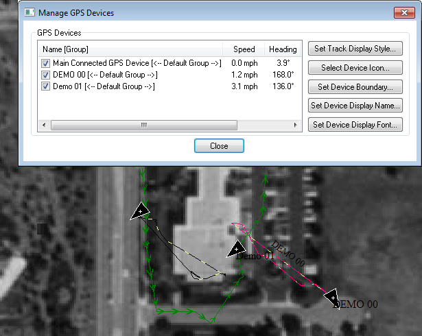
The dialog buttons perform the following functions:
- Set Track Display Style - Select the drawing style to use when displaying the track log for the selected device.
- Select Device Icon - Select the icon to use for the selected device on the main map display. Choose from one of the available point symbols or choose to use the GPS vessel selection, which allows for direction of travel to be easily visualized.
- Set Device Boundary - Select a rectangular or polygonal boundary to restrict the selected GPS device(s) to. If a device travels outside its allowed boundary, a warning message will be displayed.
- Set Device Display Name - Sets the name to use for the selected GPS device when displaying it on the map display and in the device list.
- Set Device Display Font - Select the font to use when displaying the name of the selected device on the map.
Right-click on the device list for additional options, including the ability to set text to display when hovering over the device with the mouse cursor on the map, as well as the ability to group the devices and set styles by group.
Tracking Multiple GPS Devices
Global Mapper supports tracking multiple GPS device locations using the following options:
This works with the multi-plexing hardware that merges position information from multiple GPS devices in to a single NMEA stream with special sentences. We support the following:
- RaveonTech (ravtrack.com) - embeds multiple GPS device locations using $PRAVE sentences
- InStar - uses $PCDLI sentences
- $GPWGT - standard NMEA string for multi-vehicle tracking (rarely used)
- SubSea - uses $GID and $HID sentences. The $GID is for position and $HID is just for heading. The string starts with $G or $H, then the next 2 characters are the ID of the device position being updated (like $H01, $H02, etc.). More information:
/* Position Message Format: $GID,123519,4807.038,N,01131.000,E,2,08,0.9,545.4,M,46.9,M,5.6,0133*<checksum>
Where: $G GPS Positioning Fix Data Message ID Unique vehicle/vessel identification number 123519 Fix taken at 12:35:19 UTC 4807.038,N Latitude 48 deg 07.038' N 01131.000,E Longitude 11 deg 31.000' E 2 Fix quality indicator (ie; DGPS mode) 08 Number of satellites being tracked 0.9 Horizontal dilution of position 545.4,M Altitude, Meters, above mean sea level 46.9,M Height of geoid (mean sea level) above WGS84 ellipsoid 5.6 Time in seconds since last DGPS update 0133 DGPS station ID number *<checksum> The checksum data, always begins with * */
/* Heading Message Format: $HID,173.9,T*<checksum>
Where: $H Heading True North Data Message ID Unique vehicle/vessel identification number 173.9 Heading in degrees relative to True North *<checksum> The checksum data, always begins with * */