The GeoCalc
Projection Mode
allows Global Mapper users administrative control of geodetic parameters
through Geographic Calculator*. Once
enabled, Global Mapper will access the Geographic
Calculator datasource (GeoCalc Library) for data reprojection and
coordinate transformations.
Additional support is enabled for:
- Vertical
datum transformation support for an expanded library of local geoids,
ellipsoids, and local offset models.
- Vertical datum support for Tidal vertical references in North America.
- Custom coordinate system support and easy sharing of custom parameters between multiple users.
- The
Administrative control of geodetic parameters allows administrators to
limit Global Mapper access to the GeoCalc Coordinate Transformation Library
through Geographic Calculator, so that users only see and use what you
decide via Geographic Calculator.
For Example if users only work with data in Canada, you can shut off all non-Canadian systems in Geographic Calculator and these would then be unavailable in GeoCalc Projection.
If you have downloaded and registered Global Mapper and Geographic Calculator on your computer,
the GeoCalc Projection mode may be enabled by clicking the Enable GeoCalc
Projection Mode button in the GeoCalc toolbar.
 Auto-select most accurate Transform
In Geographic Calculator, Datum Transformations have an Accuracy field.
Datum Transformations from EPSG have been updated to include the accuracy
values specified in the EPSG dataset, the user may also set these to set
a known, numerical, accuracy value through the Datasource menu in Geographic
Calculator.
Performing a Projection change or a Transformation
using GeoCalc Projection
To perform a Projection
change or Coordinate Transformation using the Geographic Calculator datasource,
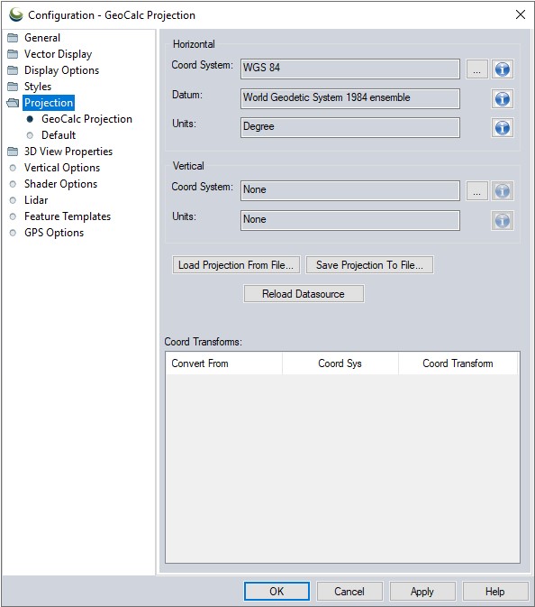
go to the Projection section of the Configuration menu. When GeoCalc mode is enabled, this menu will have been updated to reflect the additional functionalities and options.

This section displays the current Coordinate System, Datum, Units, Vertical Reference
and Vertical Units. Changing these values will initiate a Projection change,
or a Coordinate Transformation.
To save any changes made to the data's Projection, or to perform a Coordinate
System/Datum Transformation, hit the Apply button after configuring
the Coordinate System, Datum, Units, and Vertical Reference.
Load From File... this may be used to load a coordinate system contained with in a Projection (.prj), .txt or Esri aux.xml file format. Use Save Projection To File... to save a projection or system to a Projection (.prj) file.
The option to Reload Datasource may be used if a new
system has been added directly to the Geographic Calculator's datasource,
the relad option will 'refresh' the list of available systems to include
the recently added system.
Coord Transforms: - When a coordinate transformation is performed, the transformation from Geographic Calculator will populate in this window. Double-clicking on the transformation line will bring the details of the transformation up in the Geographic Calculator datasource window.
For
more information on any of the Coordinate Systems, Units or Datums available
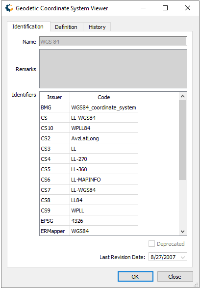
hit the blue 'I' button next to that field. This will bring up a description
from the Geographic Calculator datasource (See below).

The information window for a Coordinate System, will display the EPSG code
(if available) the Identification
tab and specific information about the Coordinate System's geographic
Envelope (region), Point Style, Datum, Projection and Parameters can be
found on the Definition tab.
Layer Projection
To use the GeoCalc Library to correct the Projection for an imported data
layer, highlight the layer in the Control Center
and select Options... and Layer Projection to select the
appropriate projection for the data layer.
The data layer's current Projection may be corrected or defined from this option. When a change is applied, if the current display projection matches the projection on the layer, the user will be asked if they would like to update the display projection to the new layer projection. This may result in additional prompts for the user to select a new transform if other existing layers are impacted.