 Create
Contours (from Terrain Grid or Lidar)
Create
Contours (from Terrain Grid or Lidar)
The Create Contours command allows the user to generate equally spaced contour lines from any loaded elevation grid data or point cloud data. To generate contours directly from point cloud data, a Global Mapper Pro license is required. Choose this option from the Analysis Menu, or the Analysis Toolbar button to generate contour lines.
Create contour lines by choosing this option in the TerrainAnalysis menu or using the  Generate Contours button from the Analysis Toolbar. This tool is also available by right-clicking on layers in the Control Center, under the Analysis sub menu.
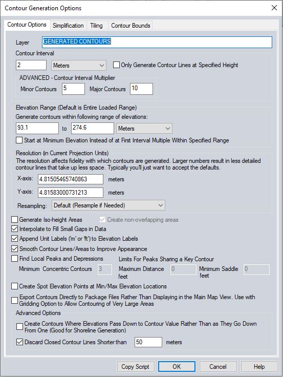
When selected, the command displays the Contour Generation Options dialog (pictured below) which allows the user to set up the contour generation process.
With Global Mapper Pro, contour lines can be generated from lidar point cloud data. If a point cloud layer is being used to generate contours, the option to Filter Lidar will be available.
Layer
Enter the layer name and description for the resulting layer of contour lines and features.
Contour Interval
This option allows the user to set the contour interval as well as the major and minor contour interval multipliers. Check the box to Only Create Lines at Specified Height to generate contour lines only at the height specified by the Contour Interval value. The previously set contour interval will be remembered by Global Mapper when next using this tool.
Elevation Range
This setting can be used to restrict which contour lines are generated (by default all loaded elevation values are considered).
Resolution
The resolution in the x and y directions control the resolution at which the loaded terrain data is sampled to generate the contour lines.
If lidar layers are chosen to generate contours from, the data is gridded at the start of the process at the specified resolution using the 'Bin Maximum' method with a default gap fill size.
Resampling
This allows the user to control how terrain layers are sampled during contour generation.
Additional Options
Generate Iso-height Areas
Select this option to generate an area feature for each generated contour interval. With Generate Iso-Height Areas enabled, select the option to Create non-overlapping areas to cut holes in the created areas as needed in order to make a discrete polygon for each contour interval. By default, these areas will be colored with the active elevation shader.
Interpolate to Fill Small Gaps in Data
Select this option to interpolate over small holes or areas of no data in the grid or lidar data when generating contour line help prevent breaks or fragmented lines.
Smooth Contour Lines
Select this option to add additional vertices along the generated line and area features to improve their appearance.
To generate a large number of contour lines over a large area, the option to export the contours directly to a package file can be used in addition to the Gridding tab options to export contours directly to package files, sometimes by passing memory limitations. Note that the contour lines will be generated so that the higher elevations are to the left of the contour line.
Find Local Peaks and Depressions
This option will generate point features at local peaks found based on user provided parameter values. The Minimum Concentric Contours value describes the minimum number of closed contours nested within each other that are needed to define a peak candidate. The first closed contour containing a peak candidate is referred to as a key contour. Peaks sharing a key contour that are further from each other than the Maximum Distance value will be identified as peaks. If multiple peak candidates are identified within the same key contour and are within the Maximum Distance value of each other, the saddle depth between them will be analyzed. If the saddle depth is greater than the Minimum Saddle value, both peaks will be retained.
Create Spot Elevation Points and Minimum and Maximum Elevations
This will generate point features at the minimum and maximum elevation locations on the loaded terrain data.
Advanced Options
Create Contours Where Elevations Pass Down to Contour Value Rather Than as They Go Down From One
This advanced option changes how the contouring works in flat areas.
If this option is checked, contours will be generated where the terrain
surface arrives at a contour height from higher terrain, rather than where
it departs a contour height for lower terrain. With a flat plain exactly
at a contour height, the result will be a contour at the base of the hill
where it starts up, rather than at the top where it starts down. This tool is most useful when using datasets that include water (like the ocean), and you want to get a shoreline contour generated where the terrain leaves the flat surface of the water.
Discard Closed Contour Lines Shorter than X meters
Select and specify a minimum length for any closed contours. Any closed (i.e. complete loop) contours less than the specified length will be marked as deleted.
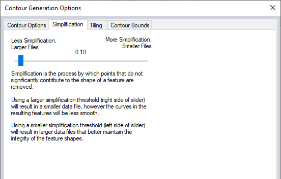
The Simplification panel (displayed below) allows the user to set up the threshold at which points that don't contribute much to the shape of the generated contour are removed in order to generate lines with less vertices.
Tiling
The Tiling panel allows the
user to break up the contour generation into smaller pieces, which can
sometimes help reduce memory requirements when generating a very large
amount of contour lines.
Contour Bounds
The Contour Bounds panel allows
the user to set up the portion of the loaded elevation grid data they
wish to consider when generating the contours.
The Generate Contours (from TIN
Areas) command allows the user to generate contour lines from any loaded
TIN Area (Triangulated Irregular Network).
*Note that when generating contours from a TIN Area not all Contour Generation Options will be available.