ECW
Enhanced Compressed Wavelet (ECW) is a popular standard for compressing and using very large images. ECW is a proprietary, patented format developed by Hexagon Geospatial.
From Global Mapper, any loaded raster, vector, and elevation grid data sets can be exported to an ECW file. ECW files are highly compressed and great for storing data such as satellite imagery. There is no size restriction on exported ECW files, so it's possible to store many terabytes worth of imagery within a single highly compressed ECW file.
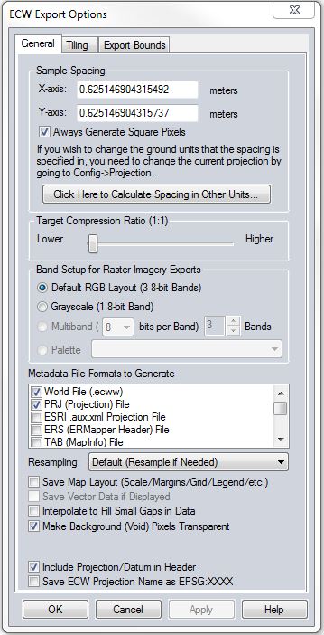
When selected, the command displays the ECW Export Options dialog which allows the user to setup the export.
The Sample Spacing section allows the user to select the grid spacing to use when generating the file. The default value is the average of the grid spacings of all the currently loaded raster and elevation overlays.
If the Always Generate Square Pixels option is checked, the smaller of the specified x and y resolutions will be used for both the x and y resolution.
Selecting Always Generate Square Pixels ensures that the resultant image file will look good even in software that is not able to deal with pixels that aren't square.
To specify the spacing in units other than those of the currently selected view/ export projection, press the Click Here to Calculate Spacing in Other Units button.
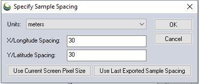
Specify the X and Y spacing of the output pixels in any of the selected units. These pixel dimensions will be translated into the units of the display projection during export. The Use Current Screen Pixel Size button will update the X and Y values to the dimensions of the map display. Use Last Exported Sample Spacing will update the X and Y values to the most recent export resolution.
Target Compression
To generate an uncompressed format file, simply slide the Target Compression Ratio slider all the way to the left (1:1 target compression ratio).
A compression ratio expresses the file-size differences between the original image and compressed image. A compression ratio of 2:1 means the original image was reduced by a factor of 2.
Band Setup
- Default RGB Layout- This option generates a 3 band RGB ECW with 8-bits per band
- Grayscale- This option generates a 1 band image with 256 scales of gray ranging from black to white.
Metadata File Formats to Generate
Select any additional metadata or projection files to be produced with the ECW export.
- Nearest Neighbor - simply uses the value of the sample/pixel that a sample location is in. When resampling an image this can result in a stair-step effect, but will maintain exactly the original color values of the source image.
- Bilinear Interpolation - determines the value of a new pixel based on a weighted average of the 4 pixels in the nearest 2 x 2 neighborhood of the pixel in the original image. The averaging has an anti-aliasing effect and therefore produces relatively smooth edges with less stair-step effect.
- Bicubic Interpolation - a more sophisticated method that produces smoother edges than bilinear interpolation. Here, a new pixel is a bicubic function using 16 pixels in the nearest 4 x 4 neighborhood of the pixel in the original image. This is the method most commonly used by image editing software, printer drivers, and many digital cameras for resampling images.
- Box Average (2x2, 3x3, 4x4, 5x5, 6x6, 7x7, 8x8, and 9x9) - the box average methods simply find the average values of the nearest 4 (for 2x2), 9 (for 3x3), 16 (for 4x4), 25 (for 5x5), 49 (for 7x7), 64 (for 8x8), or 81 (for 9x9) ) pixels and use that as the value of the sample location. These methods are very good for resampling data at lower resolutions. The lower the resolution of your export is as compared to the original, the larger "box" size you should use.
- Filter/Noise/Median (2x2, 3x3, 4x4, 5x5, 6x6, 7x7, 8x8, and 9x9) - the Filter/Noise/Median methods simply find the median values of the nearest 4 (for 2x2), 9 (for 3x3), 16 (for 4x4), 25 (for 5x5), 49 (for 7x7), 64 (for 8x8), or 81 (for 9x9) pixels and use that as the value of the sample location. This resampling function is useful for noisy rasters, so outlier pixels do not contribute to the kernel value. Some common sources of raster noise are previous compression artifacts or irregularities of a scanned map/image.
- Box Maximum (2x2, 3x3, 4x4, 5x5, 6x6, 7x7, 8x8, and 9x9) - the box maximum methods simply find the maximum value of the nearest 4 (for 2x2), 9 (for 3x3), 16 (for 4x4), 25 (for 5x5), 49 (for 7x7), 64 (for 8x8), or 81 (for 9x9) pixels and use that as the value of the sample location. These methods are very good for resampling elevation data at lower resolutions so that the new terrain surface has the maximum elevation value rather than the average (good for terrain avoidance). The lower the resolution of the export file is as compared to the original, the larger "box" size that should be used.
- Box Minimum (2x2, 3x3, 4x4, 5x5, 6x6, 7x7, 8x8, and 9x9) - the box minimum methods simply find the minimum value of the nearest 4 (for 2x2), 9 (for 3x3), 16 (for 4x4), 25 (for 5x5), 49 (for 7x7), 64 (for 8x8), or 81 (for 9x9) pixels and use that as the value of the sample location. These methods are very good for resampling elevation data at lower resolutions so that the new terrain surface has the minimum elevation value rather than the average. The lower the resolution of the export file is as compared to the original, the larger "box" size that should be used.
- Gaussian Blur (3x3, 5x5, 7x7) - the Gaussian blur methods calculate the value to be displayed for each pixel based on the nearest 9 (for 3x3), 25 (for 5x5), or 49 (for 7x7) pixels. The calculated value uses the Gaussian formula that weights the values based on the distance to the reference pixel.
ECW Format Version
Choose to export the file as ECW v2 or v3. The default behavior is as follows:
- Data with 8-bit samples will default to ECW v2 for maximum compatibility with other software that may not support v3.
- High bit depth exports will default to ECW v3.
Other Options:
Save Map Layout
The distance scale, elevation legend, and coordinate grid will be saved to the file (except when exporting elevation grids) if they are configured to show up in the main display.
Save Vector Data if Displayed
Any loaded vector data that is configured to show up in the main display will be saved to the image file (except when exporting elevation grids).
Interpolate to fill small gaps in data
Any small areas with missing data will be filled in by interpolating the surrounding valid data using an IDW method. This is useful for filling small gaps between adjacent tiles or small holes in elevation data.
Make Background (Void) Pixels Transparent:
An alpha channel will be added to the file to indicate which pixels should be treated as transparent.
Include Coordinate System/Datum in Header
The coordinate system information will be saved to the ECW header.
Save ECW Coordinate System Name as EPSG:XXXX
The coordinate system name saved in the ECW header will be formatted as ESPG:XXXX
Format Updates
| Version | Description |
|---|---|
| 26.2 | ERDAS ECW JP2 SDK update to v6.1. Supports ECW v3 exports. |