 Location Display
Tap the  Location Display button to open a list of location display modes. When a location display mode is selected the icon will appear with an orange background
  .
.
A circle icon will show the GPS location, and an arrow indicates the heading. A larger, translucent circle may also be visible, indicating the current GPS location accuracy. The GPS location icon displayed on the map can be changed in Configuration.
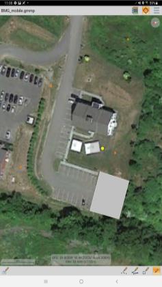
The Latitude and Longitude are displayed on the bottom of the screen. The location information will also report the elevation and accuracy.
GPS - This will show only the blue dot icon showing the GPS location.
Crosshair - This will show only the crosshair symbol in the center of the screen. If elevation data is loaded and displayed, the layer elevation at the crosshair location will be displayed.
GPS and Crosshair - This will show both the GPS location and show the crosshair symbol and location in the center of the screen.
GPS Centered - This will center the blue dot icon showing the GPS location on the screen. As you move and the GPS location changes, the blue dot icon will remain centered on the screen as the loaded data pans behind it.
Drag the map and a  crosshair symbol will be placed at the screen center. The Latitude and Longitude of the cross hair center are displayed on the bottom of the screen.
Location Display option GPS enabled.
The crosshair and coordinate display can be disabled in Configuration, so that only the blue GPS location is displayed. Turn off Show Coordinate Info to disable the crosshairs and coordinate information for the center of the map. If Always Show GPS Info is enabled, the GPS and crosshair locations will always be displayed when they are active.