This option, available in the Raster Analysis Menu, allows
you to generate a grid (and optionally areas) of roughness length
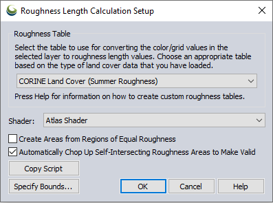
values from a land cover layer. When you select this option, the following
dialog appears allowing you to setup the roughness calculation:
The roughness grid is useful for wind power applications and can be exported to a WindSim GWS file as a roughness layer or the roughness areas can be exported to a WaSP .map file.
Several land cover data sets useful for roughness length calculation have built-in roughness conversion tables available:
- CORINE Land Cover (Summer Roughness)
- CORINE Land Cover (Winter Roughness)
- ESA CCI (Climate Change Initiative) Land Cover
- GlobCover Land Cover Map ESA 2009
- GlobCover Land Cover Map ESA 2020
- GlobeLand30 (Global Land Cover)
- NLCD - US National Land Cover Database
- VCF - Vegetation Continuous Fields (GLCF from MODIS)
Custom roughness tables can be defined in a roughness_tables.txt file in the user data file path listed on the Configuration > General > Advanced dialog. A sample roughness_tables.txt file can be found here.