The apply elevations to selected features tool adds per vertex elevation values to vector features based on either loaded terrain data, loaded Lidar data, or an existing elevation attribute.
Select one or more vector feature with the digitizer tool and right-click anywhere on the map to the Apply Elevations to Selected Features option that is located in the Analysis/Measurement sub-menu. To use this tool, there must be gridded elevation data loaded, Lidar data loaded and / or elevation attributes assigned to the vector features.
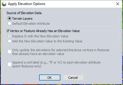
Source of Elevation Data
Terrain Layers — Selecting this option will add an ELEVATION attribute to each selected
point feature containing the elevation value at each point location from
the top-most terrain layer at that location.
Any selected line or area features that have a valid elevation from loaded terrain at each vertex location will have a set of per-vertex elevations added to the feature containing the elevation at each vertex from the loaded terrain layers.
Applying elevations from terrain requires elevation data (like
a DEM) to be loaded into the workspace. The elevation of the top most elevation layer will be applied to the selected feature at each vertex. The elevation value of the feature will be applied using the resampling method of the top most terrain layer. For elevation layers the resampling method is bilinear interpolation by default, so the elevation at each vertex will be calculated using bilinear interpolation.
Change the interpolation method in the display settings of the top most elevation layer to apply elevations using a different method of calculation.
Default Elevation Attribute — The elevation attribute assigned to the entire feature will be applied as a per vertex elevation attribute.
Lidar Layers — Selecting this option will add an ELEVATION attribute to each selected feature containing the elevation value at each point location calculated from nearby Lidar points.
Any selected line or area features will have a set of per-vertex elevations added to the feature containing the elevation at each vertex based on nearby Lidar points.
With this option you are able to select the class(es) of Lidar points from which the elevation for the vector features is calculated.
If Vertex or Feature Already Has an Elevation Value
Specify how to resolve conflict if elevation values already exist for the feature.
Replace it with the New Elevation Value — Any existing elevation values will be overridden by the value from the above source.
Add the New Elevation Value to the Existing Value —The value coming from the source specified above will be added to any existing elevation values. For example, if the vectors have an elevation value that has a number representing a height value of the object, and then the elevations are added from the loaded terrain layers, the resulting per vertex elevation values will represent absolute elevation for the vector feature.
Options
Only update the elevations for selected line/area vertices in features that already have an elevation value—
Append a unit label (e.g. 'ft' or 'm') to each elevation attribute (point features only) — With this option selected the elevation attribute will contain a unit, and not just the number. Point features have the elevation attribute updated; but unit labels can not be stored in per-vertex elevations, so this does not apply to area and line features.