Create Curvature Grid from Terrain Layer(s)
|
|
This tool requires Global Mapper Pro |
The Create Curvature Grid from Terrain Layers command generate a gridded layer depicting the curvature values present in the loaded terrain based on the selected curvature type analysis. By default, the Curvature Shader will be applied to the generated Curvature Grid layers.
Find this tool in the Terrain Analysis dropdown menu.
When selected from its location in the Terrain Analysis menu, the command opens the Curvature Grid Setup dialog, which allows the user to select the analysis method for the curvature grid creation.
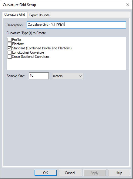
The new layer Description can be customized. The description defaults to Curvature Grid - %TYPE% where the %TYPE% variable will be determined by the selected curvature type.
Curvature Types
Several methods are available for curvature analysis. Each method checked in this list will generate a separate curvature grid layer in the workspace.
Profile - curvature parallel to the slope indicated the direction of maximum slope
Planform - curvature perpendicular to the direction of the maximum slope
Standard (Combined Profile and Planform) - combines the profile and plan curvature into a single value
Longitudinal Curvature - curvature of the slope normal and slope direction
Cross Sectional Curvature - curvature of the slope normal perpendicular to slope direction.
Sample Size
The Sample Size section allows the user to select the grid spacing to use when generating the curvature grid. This will be the resolution at which the terrain grid will be sampled to generate the curvature grid. The entered value will serve as the sample spacing in the X and Y directions. The default value is the average of the grid spacings of all the layers being used in the analysis. Lowering this value will sample the terrain at a higher resolution and may increase processing time.
Export Bounds
The Export Bounds panel allows
the user to set up the portion of the loaded elevation grid data that will be used in the creation of the curvature grid.