Map Catalog
A Map Catalog is a collection of map files which are grouped together to allow for easy loading, viewing, and export. Layers in a map catalog will be loaded and unloaded as needed for display and export. This can greatly reduce the load time and memory requirements for working with very large collections of data.
Create New Map Catalog
The Create New Map Catalog command can be used to create a map catalog. A Map Catalog may also be created from the Control Center.
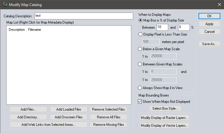
Upon selecting this command and then selecting
the file to save the map catalog to, the Modify
Map Catalog dialog (shown below) will be displayed, allowing files
to be added to the catalog, and to specify at what zoom level data layers
are loaded for display. Note that this setting will override any Map Zoom settings for individual layers. The display of the map bounding boxes can be set
up even when you are zoomed out too far for the actual map data to display.
By default, the map bounding boxes are displayed using the style set for the Map Catalog Layer Bounds type.
Metadata and projection information about layers in the map catalog can be obtained by right-clicking on them in the Map List and selecting the appropriate option.
Map catalogs can be modified again after loading them by opening the Control Center, selecting the map catalog layer, then pressing the Options... button. For more information on the display settings, see Layer Options.
Add Selected Layers to Map Catalog
This option is available from the Control Center context menu under the Layers sub-menu, or from the top level Layers menu.
Highlight a layer in the Control Center then choose this option to add the layers to a map catalog. Choose an existing map catalog or enter a new name in the Save As dialog to create a new map catalog. If an existing map catalog is selected, there is a dialog prompt with options to add to the existing catalog or create a new catalog.
Remove Map at Cursor from Map Catalog
This option is available in the context menu of the digitizer, or in the Digitizer menu under Advanced Operations.
This will remove any image layer at the current cursor location from the map catalog, and automatically save the map catalog changes.