Vector Display Configuration
The Vector Display Folder controls options for the display of vector data (areas, lines, and points).
Vector Display
Access the Vector Display Configuration by selecting the  Configuration button from the File Toolbar or Tools menu, and navigating to the Vector Display section in the Vector Display folder.
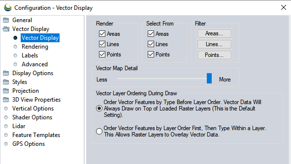
Render
The Render section contains the settings for the display of vector features. These settings allow users to turn entire classes of features on and off. For a finer degree of control, see the Filter section described below.
Select From
The Select From section contains the settings which determine which vector object types (i.e. areas, lines, points) the Digitizer or Feature Info Tool will consider when selecting objects.
Filter
The Filter section allows you to select which specific area, line, and point feature types you wish to display. By default, all feature types are displayed.
Vector Map Detail
For use with classified vector data , the Vector Map Detail slider controls the display of feature classes on the map. By default the slider is set to the far right at More causing all vector data to be displayed regardless of zoom scale. This setting does not affect the display of raster or elevation data sets.
Each vector classification has a detail level value that controls when it is displayed. Feature classes with lower values require you to be zoomed in on the data in order to see the features if the detail slider is not all the way to the right. Moving the slider to the left towards Less will hide more minor feature classes at lower zoom levels to simplify the map. For example, if you had all of the roads for an entire state loaded at once, you could slide the detail slider to the left to make minor roads hidden until you zoomed in sufficiently far on the data.
Vector Layer Ordering During Draw
The Vector Layer Ordering During Draw settings control the order in which data from vector layers is displayed. The default setting (order by type before layer order) is that all vector data is drawn after any other loaded raster or elevation data, regardless of how the vector layers are ordered in the Control Center. All area features from all layers will be drawn first, followed by all line features from all layers, and finally all point features from all layers. Within each grouping (e.g. areas, lines, or points), the drawing order will be determined first by type, and then by layer ordering.
The second draw order option (order first by layer, then by type within a layer) specifies that the order of the vector layers in the Control Center should take precedence over all else when drawing. This means that if a vector layer is before a raster layer in the Control Center's draw order, that vector layer will draw underneath that raster layer if they overlap.