Global Mapper Mobile Package File
Global Mapper Mobile files (*.GMMP) package currently loaded data for use in the Global Mapper Mobile application.
GMMP files support vector, raster, and point cloud data.
A Global Mapper Mobile Package file can be created from data loaded in a workspace using the File Menu > Export > Export Global Mapper Mobile File... option or the Mobile Data Management tool.
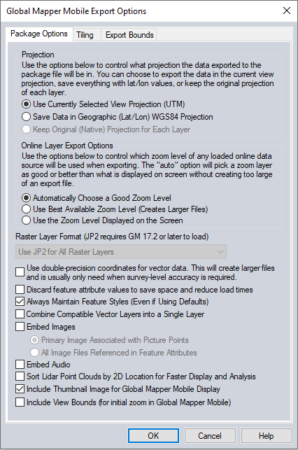
Coordinate Reference System
Choose to export the data in the current workspace coordinate system, or a geodetic system using WGS84 and latitude/longitude coordinates. Global Mapper Mobile 2.0 or later is required on the mobile device to support a package with data in the current workspace coordinate reference system.
Online Layer Export Options
In the Online Layer Export Options section of the panel, select how layers loaded from the Download Online Imagery/Topo/Terrain Maps menu are exported. Most online data provides different levels of detail depending on the zoom level when the request is made to the server. Choose to automatically determine the zoom level, use the highest available level of detail, or use the zoom level currently displayed on the screen. This setting will impact the resulting file size.
Other Options
Raster Layer Format - JPEG2000 images are the default method for imagery in packages. This reduces the file size compared to previous package files that stored imagery in GeoTiff format.
Use Double-Precision Coordinates for vector data setting will store coordinate data for vector features using double precision format, which allows for greater accuracy in the coordinate values (survey level) but greatly increases the file size.
The Discard feature attribute values option will remove all the attributes from all vector data.
When enabled the Always Maintain Feature Styles option will export vector features with their currently displayed styles. When the package file is loaded the feature styles should be maintained.
The Combine Compatible Vector Layers into a Single Layer option causes all vector features with the same native projection to be combined into a single layer within the package file rather than maintaining their original layer structure.
The Embed Images Associated with Picture Points option embed any images associated with a vector feature (like points created from an EXIF JPEG file) in the package file for easy sharing of linked images and use on other systems.
The option to embed the Primary Image Associated with Picture Point will only save the primary linked image to the package file. The primary linked image will be noted with an asterisk (*) in the Link Attribute Handling dialog of the Feature Info Tool.
The option to embed All Image Files Referenced in Feature Attributes will export all linked images using attributes like IMAGE_LINK, LINK, and FILE_LNK_X to the package file.
The Embed Audio option embeds recorded audio notations(s) linked to any vector features being exported. Embedded audio will be stored in the package file allowing it to be shared with the vector features and played on other systems.
Sort Lidar Point Clouds by 2D Location for Faster Display and Analysis reorders the 3D point clouds so that the points are listed in the file in sequential spatial order. This improves the point cloud processing and display speed. Unordered point clouds may be caused by the data acquisition or creation, and are particularly common in photo generated point clouds. The organization can be seen by choosing the Lidar drawing mode of Color Lidar by Point Index.
The Include View Bounds option saves and restores the view bounds/projection to be referred to when loading the GMP into an empty workspace. View Bounds is the extent of data visible or zoom level within the workspace when the GMP is exported.
Include Thumbnail Image for Global Mapper Mobile Display will also export a small image of the map for reference in the Maps list.
Include View Bounds (for initial zoom in Global Mapper Mobile) will remember the current view extent in the exported file and recreate that view when the file is loaded into Global Mapper or Global Mapper Mobile.
Note: This export shares a dialog with the Global Mapper package export. Not all options are available or applicable for mobile packages.
Simplification
This tab is available with loaded vector data. The Simplification panel allows the user to set up the threshold at which points that don't contribute much to the shape of the vector line and area features being exported are removed in order to generate features with less vertices. By default, all vertices will be kept, but the user can move the slider to the right to get rid of relatively insignificant vertices and realize significant space spacings at the cost of some fidelity.
Tiling
The Tiling panel allows the user to split up the data into regularly spaced tiles on export if desired rather than just exporting a single file.
Export Bounds
The Export Bounds panel allows the user to select what portion of the loaded data they wish to export.
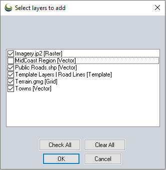
Import Global Mapper Mobile Package
Select Layers to Add
Choose the layers from the Global Mapper Mobile Package (*.gmmp) file to load into Global Mapper.