Loading Data from Bathymetric Formats
XTF (eXtended Triton) Format, MB56 Format, BAG (Bathymetry Attributed Grid) Files are all supported for import into Global Mapper. While bathymetric data is not limited to these formats, it is commonly shared in these file formats developed specifically for this type of data.
XTF (eXtended Triton) Format (*.xtf)
EXtended Triton format is used to store bathymetric data from side scan sonar, single beam echo and multi beam echo. The XTF import options allow the creation of vector or raster data from the file.
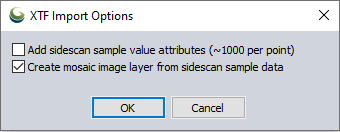
The Add sidescan sample value attributes check box will load the data as vector points representing the pings from data collection.
The Create mosaic image layer from sidescan sample data check box will load a mosaic raster layer derived from the samples. For decreased load and render speeds the mosaic resolution will be reduced if it exceeds the size 10000 x 10000 cells. SmartGrid classes will also be used for better memory management.
If both options are enabled a group of two layers will load in the workspace.
If projection information is not found for the file being loaded, Global Mapper will prompt the user to select the correct projection. The default projection for this format is Geographic (Lat/Lon). More information on selecting a projection can be found here.
MB-System MB56 Format (*.mb56)
MB56 format is used by the MB-System for seafloor mapping. When loaded into Global Mapper this format can be loaded as a raster image or vector point cloud. If both options are enabled two layers will load into the workspace.
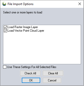
The Load Raster Image Layer check box will load the data as a 2D raster image.
The Load Vector Point Cloud check box will load the data as a 3D point cloud. This 3D layer can then be gridded into a 3D surface with the Create Elevation Grid tool.
BAG (Bathymetry Attributed Grid) Files (*.bag)
A Bathymetry Attributed Grid file will load as a 3D elevation grid layer. This layer can then be edited and analyzed with the available terrain analysis tools.
Other common bathymetric data formats
Bathymetry data is also often shared in HDF5 and NETCDF formats.