Find Ridge Lines, accessed from the Terrain Analysis Menu, allows the user to analyze the loaded terrain data to find significant ridge lines. The ridge line calculation is based heavily on the watershed generation algorithm, so see that for details on how it works. The main difference is that the ridge line operation simply inverts the terrain, and where streams of water would form are now the ridge lines in the inverted terrain.
When selected, the command displays the Ridge Line Options dialog (pictured below) which allows the user to set up the ridge line determination process.
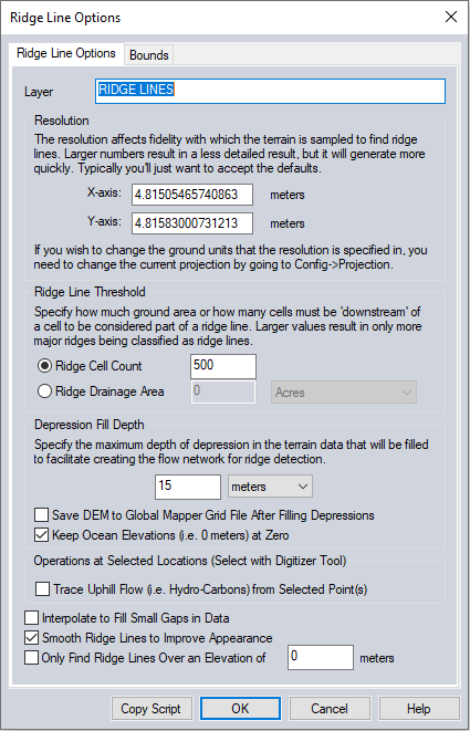
Resolution
Specify the resolution of the analyzed grid. The resolution will default to the resolution of the loaded terrain data. Increasing this resolution will speed up processing by resampling the terrain data but will produce less detailed results. The current display projection sets the units of the cell size.
Ridge Line Threshold
A ridge is determined by some threshold size of pixels that are down slope from it. This size can be determined by either a count of pixels, or a planar area.
Depression Fill Depth
Many terrain data sets will contain depressions in the data where flow would terminate unless allowed to fill the depression and spill into the surrounding terrain. The Depression Fill Depth section controls how deep of a depression will be filled before it is considered a basin and flow is allowed to terminate there. The depression fill depth value will automatically be filled in with some guess at a good value based on the range of loaded elevation values, but you might want to modify this, especially if you have relatively flat terrain with a lot of depressions. Note that it can take a while to fill particularly deep depressions. When trying to determine a good value to use for the depression fill depth, consider how high of an embankment or 'dam' the flow might encounter that you want to allow water to fill up to the top of and pour over, or also how deep of a small pond or puddle to fill and allow spilling out of. You can also check the option to Save DEM to Global Mapper Grid File After Filling Depressions to save the depression-filled terrain to a GMG file so you can load that for future watershed operations to avoid having to fill depressions again.
Trace Uphill Flow from Selected Point(s)
This option will create line features tracing the flow from points towards the ridge lines.
Interpolate to fill small gaps in data
Any small areas with missing data will be filled in by interpolating the surrounding valid data using an IDW method. This is useful for filling small gaps between adjacent tiles or small holes in elevation data.
Smooth Ridge Lines to Improve Appearance
This will perform a smoothing operation on the output ridge lines. This helps to smooth out the stair-step effect inherent in raster analysis.
Only Find Ridge Lines Over an Elevation
Check this option to only create ridge lines above a specified elevation value.
Automatically Style Lines to Highlight Flow
Automatically change the line width of the generated line features based on multiples of Ridge Cell Count. Line color is based on Unknown Line Type.