Raster Formats Configuration
The Raster Formats section in the General Configuration options provides a number of settings for the loading of Raster data including imagery and terrain data.
Access the Raster Formats Configuration by selecting the  Configuration button from the File Toolbar or Tools menu, and navigating to the Raster Formats Configurationsection in the General folder.
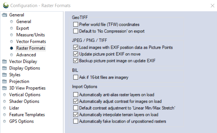
GeoTIFF
Prefer World File (TFW) Coordinate
If checked, this option specifies that for GeoTIFF files which also have accompanying TFW files, the coordinates from the TFW file will be used rather than the coordinates embedded in the GeoTIFF file.
Default to No Compression
If checked, when doing a GeoTIFF export the compression will default to 'No Compression' (if available).
JPEG / PNG / TIFF/ IIQ
Load images with EXIF position data as Picture Points
Checkedby default, when image files that contain EXIF position information are loaded they will appear in the workspace as picture points: camera icon point features which mark the location of the image, and show the image when clicked on.
Un-check this option to load the full image (for top-down images that have EXIF position information) instead of automatically creating a picture point. If EXIF position data is present, images can automatically be projected at the geotagged location using a pixel size of 2mm. With this option unchecked, users will be prompted to select a position when loading the image.Update Picture Point EXIF on Move
With this option enabled, moving a picture point will update the location information in the image's EXIF to reflect the new location. This affects the original file outside of Global Mapper.
Backup Picture Point Image on Update EXIF
When a picture point's EXIF is updated by a move, this option saves a backup of the original, unmoved, file in a "BACKUP" sub folder in the image file's location. With this option enabled, the EXIF will not be updated if the back up fails.
BIL
Ask if 16-bit files are imagery
If checked, this option will cause the user to be prompted to choose whether 16-bit BIL files that are encountered are elevation or imagery files. If not checked, any 16-bit BIL files will be assumed to be elevation files.
Import Options
Automatically Anti-Alias Raster Layers on Load
If checked, this option specifies that raster imagery/ scanned map layers will have bilinear resampling enabled automatically when loaded to smooth appearance. If not checked then the default nearest neighbor (i.e. no resampling) option will be used.
Automatically Adjust Contrast for Images on Load
If checked, this option applies automatic contrast adjustment of imagery with more than 8 bits per color channel on import.
Default Contrast Adjustment to Linear Min/Max Stretch
If checked, this option specified that layers that come in with automatic contrast adjustment enabled by default (primarily imagery with more than 8 bits per color channel) will default to using the linear min/ max stretch contrast adjustment mode rather than the standard deviation adjustment.
Automatically Interpolate Terrain Layers on Load
If checked, this option specifies that gridded elevation layers will have the default bilinear resampling enabled automatically when loaded to smooth appearance. If unchecked terrain layers will use the nearest neighbor (i.e. no resampling) option.
Automatically Fake Location of Unpositioned Rasters
If checked, this options causes the location of any un-positioned raster files to automatically be faked to allow display. This means rather than being prompted to rectify, fake the position, or cancel the load, the "fake position" option would just be chosen automatically.