Map Zoom
This tab controls which zoom levels/ scales the layer (or group) will be displayed at.
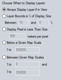
Choose to have layers display below a certain zoom scale, between scales, or when the map is a certain percentage of the map display size or the map resolution reaches a certain level.
Always Display Maps if in View
This is the default setting for layers, except for Map Catalogs. The layer will always display when it is inside the map display extent. The display of raster data at different zoom levels will be affected by the Resampling Method.
Map Box is % of Display Size
Display the layer when the bounding box is within the specified percentage of the display size. If the upper range is 0, the map will always show above the bottom range. For example the default values will display the layer when the layer extent is 10% of the overall display extent. Otherwise it will show between the specified ranges.
Display Pixel is Less Than Size
The layer will appear on the map when the display pixel (based on the monitor / display resolution ) can represent the given meters per pixel resolution, or less (higher resolution).
Below a Given Map Scale
The layer will appear when the scale of the map view is at the given scale or smaller (zoomed in further). The display scale is visible in the bottom bar of the application.
Between Given Map Scales
The layer will appear when the map display is between the given scales. The display scale is visible in the bottom bar of the application.