GeoPackage
Global Mapper supports import and export of OGC GeoPackage data sets. A GeoPackage is a SQLite database file that can contain one or more vector data tables, one or more tile pyramid* data sets, or both.
Data in a workspace can be exported to GeoPackage format with File Menu > Export >Export GeoPackage...
When importing a GeoPackage data set, all of the data will be imported into a Control Center group named after the input file, with each data set in its own layer. The name of the layer will be the same as the name of the table where the data is stored.
When exporting a GeoPackage data set, each loaded vector layer will be exported to its own data set in the GeoPackage. All of the loaded raster data will be exported to a single tile pyramid* data set.
To append data to an existing Geopackage file, select the existing file when exporting. With this selection Global Mapper will open the existing file and add or replace the tables being exported.
Note: * GeoPackage tile pyramids can only contain images, not elevation data.
Export GeoPackage
To export a GeoPackage, select File> Export> Export GeoPackage. The GeoPackage Export options dialog will appear.
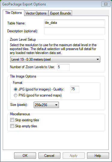
Tile Options
Table Name
The name of the table in the GeoPackage where the tile pyramid data will be stored. This is required.
Description
An optional description of the data. This will be displayed in the layer metadata when it is imported into Global Mapper.
Export Each Raster Layer to a Separate Table
With this option checked, each raster layer will be exported to a different table and the option to automatically choose a good zoom level for each layer will be available.
Zoom Level Setup
Automatically choose a good zoom level for each layer
With the option to Export Each Raster Layer to a Separate Table enabled, this option allows Global Mapper to determine the most detailed zoom level for each layer based on the source data resolution.
Use the same zoom level for all layers
Similar to other tiled export formats such as Google Maps tiles, this defines the most detailed zoom level that will be included in the tile pyramid.
Number of Zoom Levels
Indicates how many zoom levels to export. For example, if zoom level 19 with 5 zoom levels is selected, the result is a tile pyramid containing zoom levels 19, 18, 17, 16, and 15.
Tile Image Options
Format
The tiles can be stored in JPG or PNG data format. With JPG, the quality level (between 25 and 100) can also be specified.
Size
Choose the size in pixels for each tile.
Miscellaneous
Skip existing tiles
This option skips tiles that have already been generated. This is good for continuing a GeoPackage export that was not completed where it was left off, by saving with the same name to the same location.
Skip empty tiles
Do not include tiles that contain no data.
Vector Options
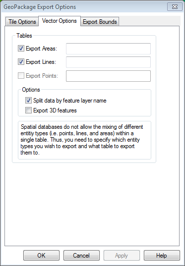
Depending on the types of data that are currently loaded, there will be options to export area, line, and/or point tables. Note that the table name is required unless the Split Data by Feature Layer Name option is selected.
Export Areas
Check this option to export area features, and type in the table name.
Export Lines
Check this option to export line features, and type in the table name.
Export Points
Check this option to export point features, and type in the table name.
Options
Split Data by Feature Layer Name
If this is checked, the data will be exported into a separate table for each layer (still based on feature type). If this option is selected, it is not necessary to type a table name. The layer name will be used for the table name. If a table name is specified, it will be used as a prefix with the layer name.
Export 3D features
If this is selected, features will be exported with a Z value.
Format Updates
Below is a summary of recent changes to format support:
| 18.2 | Added support for importing GeoPackage 1.1 databases. [Item #21586] | |
| 18.0 | Added support for importing and exporting OGC GeoPackage format files, including both vector data and tile pyramids [Item #13200] |