Lidar LAS and LAZ
Loading LAS / LAZ
Loaded lidar data in LAS or LAZ format will display the Lidar Load options dialog. For more information, see Lidar and 3D Point Cloud Load Options
Global Mapper can load both Lidar files that match the ASPRS specification, as well as other custom non-ASPRS files, and Cloud Optimized Point Clouds (COPC). For more information on customizing class names, see Lidar Class Properties.
Lidar data can be loaded directly, or loaded from within a zipped format. The following extensions are recognized: *.las; *.las.gz; *.laz; *.bin; *.tar.gz; *.tgz; *.zip; *.7z.
Export LAS / LAZ
The Export Lidar LAS command or Export Lidar (LASzip) File command can be accessed through File>Export Vector/Lidar Format... Select Export Format submenu.
These export options allows the user to export any loaded 3D vector data sets (like 3D point clouds loaded from other LAS files) to new lidar LAS or LAZ format file. Both formats share the same export options described below. If the source data came from a Lidar format file, like a LAS or MrSid file, the attributes from the original data will be maintained. Exports also support Cloud Optimized Point Clouds (COPC).
See Also SAVE - Save Changes Over Original File Data
For other (non-lidar) points being exported to a LAS/LAZ format, in addition
to the base position and elevation, if there is an INTENSITY attribute
available for the point, the value of that attribute will be exported
as the intensity for the point in the exported LAS file.
Exporting to Lidar (LASzip) will create a compressed LAZ file. This offers lossless compression for Lidar data, which
makes the Lidar files much smaller.
When LAS or LAZ is selected as the export format, the command displays the
Lidar LAS/LAZ Export Options dialog, which allows the user to setup
the export.

The Tiling Panel in the Lidar/LAZ Export Options contains options for setting
up the tile spacing and vertical units
Export Bounds will allow the user
to specify export boundaries for the Lidar data by corner coordinate values,
a drawn box, the Military Grid Reference System, or the data may be cropped
to a selected feature.
Options
The LAS Options tab is used to specify the Elevation Units, Filter Lidar points, and to set the Vertical Coordinate System and flight date to be stored in the export's Header field and Header formatting options.
Save Color Value for Each Point From Points or Raster Layers will color each point by overlapping point or raster data.
Use Save Height Above Ground Instead of Elevation to calculate the height of Lidar points relative to the ground, and save as the elevation values.
Use the Filter Output by Elevation/Class/Color
to filter Lidar points upon export.
Vertical Coordinate System
Specify the vertical coordinate system to use in the metadata value. Note this does not transform the vertical datum of the data, it just sets the metadata value. For information on vertical transformations, see GeoCalc Mode: Projections and Datums
Advanced Header Fields/Options
Format Version - Specify the LAS format to use for the output file. For more information, see https://www.asprs.org/divisions-committees/lidar-division/laser-las-file-format-exchange-activities
If "Default" is selected, Global Mapper will choose the lowest version that preserves all fields present in the data being exported.
Since Global Mapper 19.1, LAZ files may be exported in v1.1 though 1.4.
File Source ID -If the file was derived from an original flight line, this is often the flight line number, but it can also be customized for merge or extract operations. A value of 0 means that an ID has not been assigned. This value will be auto-populated from the data, and only needs to be modified if incorrect. For more information see Las Specifications
Global Encoding -This designates properties about the file, such as how to interpret GPS time and CRS information. This value will be auto-populated from the data, and only needs to be modified if incorrect.
More info from Las 1.4 Specification1
This is a bit field used to indicate certain global properties about the file. In LAS 1.2 (the version in which this field was introduced), only the low bit is defined (this is the bit, that if set, would have the unsigned integer yield a value of 1). This bit field is defined as:
Table 4: Global Encoding - Bit Field Encoding
Bits Field Name Description 0 GPS Time Type The meaning of GPS Time in the point records. If this bit is not set, the GPS time in the point record fields is GPS Week Time (the same as versions 1.0 through 1.2 of LAS). Otherwise, if this bit is set, the GPS Time is standard GPS Time (satellite GPS Time) minus 1 x 10⁹ (Adjusted Standard GPS Time). The offset moves the time back to near zero to improve floating point resolution. 1 Waveform Data Packets Internal If this bit is set, the waveform data packets are located within this file (note that this bit is mutually exclusive with bit 2). This is deprecated now. 2 Waveform Data Packets External If this bit is set, the waveform data packets are located externally in an auxiliary file with the same base name as this file but the extension *.wdp (note that this bit is mutually exclusive with bit 1). 3 Return numbers have been synthetically generated If this bit is set, the point return numbers in the point data records have been synthetically generated. This could be the case, for example, when a composite file is created by combining a First Return File and a Last Return File. In this case, first return data will be labeled “1 of 2” and second return data will be labeled “2 of 2.” 4 WKT If set, the Coordinate Reference System (CRS) is WKT. If not set, the CRS is GeoTIFF. It should not be set if the file writer wishes to ensure legacy compatibility (which means the CRS must be GeoTIFF) 5:15 Reserved Must be set to zero
System Identifier -This designates the system that generated the file. This value will be auto-populated from the data, and only needs to be modified if incorrect.
The version 1.0 specification assumed that LAS files are exclusively generated as a result of collection by a hardware sensor. Subsequent versions recognize that files often result from extraction, merging or modifying existing data files. Thus System ID becomes:
Table 5: System Identifier
Generating Agent System ID Hardware system String identifying hardware (e.g. “ALTM 1210”, “ALS50”, “LMS-Q680i” etc. Merge of one or more files “MERGE” Modification of a single file “MODIFICATION” Extraction from one or more files “EXTRACTION” Reprojection, rescaling, warping, etc “TRANSFORMATION” Some other operation “OTHER” or a string up to 32 characters identifying the operation
Flight Date - Date of data collection flight or date of data editing. This value will be auto-populated from the data, and only needs to be modified if incorrect.
Save Classes 32-233 in LAS 1.1/1.2 (Non-Standard) - This setting only applies only when exporting LAS format 1.1 or 1.2 . The LAS 1.1 and 1.2 specifications only support classes up to 31, but some software that only reads LAS 1.1 and 1.2 can recognize 256 classifications. This creates non-standard files for v1.1 or 1.2 files.
Save Projection in LAS/LAZ Header- This setting is enabled by default. Unchecking it will omit CRS information from the file header.
Offset and Scale is used in the file compression to reduce the file size. Global Mapper will automatically calculate an optimal offset and scale value, or use the following settings to customize the offset and/or scaling:
- Use Custom XYZ Header Offset/Scale
- Keep Source File Offset/Scale if Possible
Export Extra Non-standard Fields if Present - This option applies to extra field streams that have been read from imported LAS/LAZ files.
Sorting
The Sorting tab allows users to specify a point sort order from Lidar data attributes either in a descending or ascending order, which is then saved into the exported Lidar file. The default setting will be set to Do Not Sort.
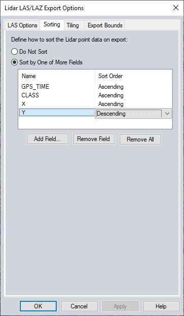
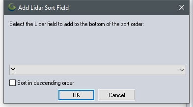
Click the Add Field button to add additional fields. The default Sort Order when adding a new field is set to Ascending. Check the box for Sort in descending order to change the sort order for the newly added field. To delete a listed field, select one that is listed, then click the Remove Field button. To delete all fields, click the Remove All button.
Batch
Conversion - Apply Color from Imagery to Lidar
This option will be available with Batch Conversion exports if you have imagery loaded before you do the batch conversion and choose to create a Lidar LAS or LAZ file from vector data. (This option requires a Global Mapper Pro license.)
Format Updates
Below is a summary of recent changes to LAS and LAZ format support:
| 26.1 | Added ability to auto recognize WKT2 CRS information in LAS/LAZ files. |
| 26.0 | Added support for reading and displaying Extended Variable Length Records (EVLRs) fields from LAS / LAZ files. |
| 20.1 | Dramatically sped up the creation of map catalogs from large numbers of Lidar LAS/LAZ files. [Item #25982] |
| 20.1 | Added support for storing SCAN_ANGLE and BEAM_ANGLE attributes in scan angle for LAS/LAZ exports from point features.[Item #25557] |
| 20.1 | Added option when batch converting to new Lidar LAS/LAZ files to control whether or not the projection/datum is included in the exported file header. [Item #25202] |
| 20.0 | Updated LAS/LAZ 1.4 export to fully comply with LAS specification when using point types 6-10 (i.e. NIR data included). Also made scan angle conversion exact and made GPS times convert based on the global encoding value in the header. [Item #23720] |
| 19.1 | Added full Lidar LAS options tab to the options dialog displayed when exporting new LAS/LAZ files from loaded grid data (rather than from Lidar/vector data). This allows setting LAS/LAZ header options, including LAS version, vertical coordinate system, flight date, etc. [Item #22957] |
| 19.1 | Added support for loading Lidar LAS/LAZ and PLY files that store ECEF (Earth-Centered Earth-Fixed) coordinates. The ECEF coordinates will automatically convert to whatever projection the user selects to use. |
| 19.1 | Write out LAS/LAZ files with feet units with US Survey Feet EPSG code (9003) for elevation units rather than International Feet code (9002). |
| 19.1 | Improved storage for vertical datum and CS metadata in exported LAS/LAZ files. The proper CS based on the selected elevation units and vertical datum will be used if there are multiple defined vertical CS codes for the same datum (i.e. NAVD88 with feet or meters). The list of available vertical coordinate systems is also much larger. |
| 19.0 | Added support reading and writing LAZ (LasZip) files with the LAS 1.4 files, like 255 classifications and NIR color bands. |
| 18.2 | Added option to only load Lidar points within a particular elevation range. The new option is on the Lidar import dialog displayed when loading one or more Lidar files (like LAS/LAZ). |
| 17.0 | [LIDAR MODULE ONLY] Added option to treat the intensity values as a NIR (near infrared) channel for Lidar point clouds. Some Lidar point clouds store the NIR value in intensity, as NIR wasn’t available in older LAS/LAZ versions. In other cases, the intensity value can act as an approximation for the NIR channel. |
| 17.0 | [Scripting] Added support for setting the GUID field in exported LAS/LAZ files when using the EXPORT_VECTOR script command. |
| 16.2 | [LIDAR MODULE ONLY] Allow changing the name to use for Lidar classifications by right-clicking on the classification on the Lidar tab of the Configuration dialog. Any exported LAS/LAZ files will also store the custom Lidar names in the header. You can change the color assigned to Lidar points in that manner now as well. |
| 16.2 | Added support for custom Lidar class names from LAS/LAZ files. Any custom type names are now displayed on the Lidar import dialog and on the Feature Info dialog when displaying information about a selected point. |
| 16.2 | [LIDAR MODULE ONLY] When batch converting to LAS/LAZ 1.1 format files and checking to apply color from loaded imagery, bump the version up to 1.2 since color wasn’t added until that version. |
| 16.0 | [LIDAR MODULE ONLY] Added option to Lidar LAS/LAZ export to filter the export so that only points that are within a given elevation range, near any one of a list of colors, within a list of allowed classes, within a scan angle range, and/or within a list of point source IDs are exported. |
| 16.0 | [Scripting] [LIDAR MODULE ONLY] Support filtering exports to Lidar LAS/LAZ files by point attributes like elevation, scan angle, classification, color, etc. with the EXPORT_VECTOR and GENERATE_ELEV_GRID commands using new parameters LIDAR_FILTER, LIDAR_COLOR_FILTER, LIDAR_COLOR_DIST, LIDAR_SCAN_ANGLE_RANGE, LIDAR_ELEV_RANGE, and LIDAR_SOURCE_ID_LIST. |
| 15.2 | [Scripting] Added support for disabling the write of the projection to an exported LAS/LAZ file header in a script by adding NO_PROJ_HEADER=YES to the EXPORT_VECTOR command. |
| 15.2 | Added option to keep the original file offset/scale when exporting to Lidar LAS/LAZ files. This is useful if you have some kind of requirement to keep the original offset/scale in the header rather than having an optimal offset/scale calculated. |
| 15.2 | Added option to specify the Flight Date to store in the LAS/LAZ file header when exporting. |
| 15.2 | [Scripting] Added support for disabling the write of the projection to an exported LAS/LAZ file header in a script by adding NO_PROJ_HEADER=YES to the EXPORT_VECTOR command. |
| 15.1 | [LIDAR MODULE ONLY] Added option when batch converting to Lidar LAS/LAZ files to apply color from loaded imagery. |
| 15.1 | Made batch converting Lidar point clouds with RGB colors to new LAS/LAZ files automatically include the colors in the output files. |
| 15.0 | [LIDAR MODULE ONLY] Added support for applying colors from loaded imagery layers to loaded Lidar point clouds directly in memory. This allows easily creating a fully colorized Lidar data set without having to export to a new LAS/LAZ file first. |
| 15.0 | [LIDAR MODULE ONLY] Added support for exporting elevations to LAS/LAZ points from a point cloud as a ‘height above ground’. There is a new checkbox option on the LAS/LAZ export dialog allowing you to specify that the saved Z values should be heights above ground rather than the normal elevation. You can also script export of height above ground by adding SAVE_HEIGHTS_ABOVE_GROUND to the EXPORT_VECTOR command for LAS/LAZ export. |
| 15.0 | [Scripting] Added support for supplying the flight date for an exported Lidar LAS/LAZ file with a FLIGHT_DATE parameter for an EXPORT_VECTOR or EXPORT_ELEVATION script command. |