ASRP and ADRG File
Loading
ADRG is a raster format typically used by military and other government organizations. To load ADRG files, load the TRANSH01.THF file from the ADRG file hierarchy or load the ADRG data directly from a .zip file. Global Mapper v6.02 and above can load files in this format.
ASRP is a raster format typically used by military and other government organizations. The USRP varient simply uses a UTM projection rather than unprojected lat/lon. To load ASRP/USRP files, simply load the TRANSH01.THF file from the ASRP/USRP file heirarchy or load the ASRP/USRP data directly from a .zip file. Global Mapper v6.07 and above can load files in the ASRP format. Global Mapper v7.04 and later can also handle the USRP files.
Exporting
To export loaded data to an ASRP or ADRG file, choose File > Export > Export Raster/Image Format... then select ASRP/ADRG File from the Select Export Format list
The Export ASRP/ADRG command allows the user to export any loaded raster, vector, and elevation grid data sets to a 24-bit RGB ASRP (1.1 or 1.2) file, or to an ADRG format.
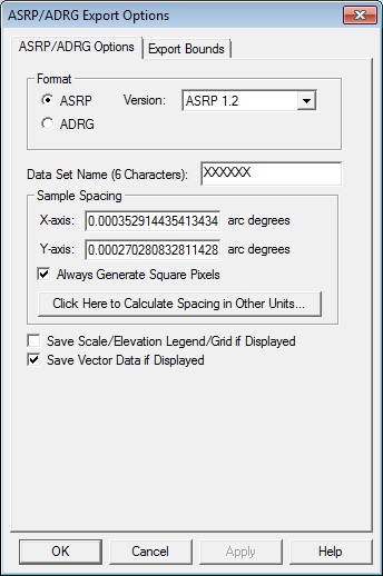
When selected, the command displays the ASRP/ADRG Export Options dialog which allows the user to setup the export. The dialog consists of a General options panel and an Export Bounds panel which allows the user to set up the portion of the loaded data they wish to export.
General Options
Format
Specify the desired output format. With an ASRP output, select the version.
Data Set Name - Specify a 6 character name for the data set.
The Sample Spacing section allows the user to select the grid spacing to use when generating the file. The default value is the average of the grid spacings of all the currently loaded raster and elevation overlays.
If the Always Generate Square Pixels option is checked, the smaller of the specified x and y resolutions will be used for both the x and y resolution.
Selecting Always Generate Square Pixels ensures that the resultant image file will look good even in software that is not able to deal with pixels that aren't square.
To specify the spacing in units other than those of the currently selected view/ export projection, press the Click Here to Calculate Spacing in Other Units button.
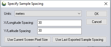
Specify the X and Y spacing of the output pixels in any of the selected units. These pixel dimensions will be translated into the units of the display projection during export. The Use Current Screen Pixel Size button will update the X and Y values to the dimensions of the map display. Use Last Exported Sample Spacing will update the X and Y values to the most recent export resolution.