Calculate Elevation / Slope Statistics for Selected Features

This tool will calculate a number of elevation and slope statistics for selected vector

If gridded elevation data (i.e. DEMs) is loaded and at least one feature is selected with the Digitizer tool, the Calculate Elevation/Slope Stats for Selected Feature(s)...option is available in the Digitizer menu or context menu under Analysis/ Measurement or Attribute/ Style Functions.

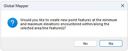
The Calculate Elevation/Slope Stats for Selected Feature(s)... will also provide an option to create point features at the minimum and maximum elevations of each selected feature.

Selecting this option will examine the loaded terrain within the selected area feature(s) and, if terrain is found within a selected area, add MIN_ELEV, MAX_ELEV, AVG_ELEV, STD_DEV_ELEV, MAX_SLOPE, AVG_SLOPE, and STD_DEV_SLOPE attributes to the area containing the minimum, maximum, average, and standard deviation of elevation values encountered within the area feature as well as the maximum, average, and standard deviation of the slope values (in degrees) found within the area.

Area Statistics

The calculated statistics for area features are as follows:

  • ASPECTClosed— Direction that the slope is facing (i.e. south facing slope is 180, north facing is 0). This is the most commonly occurring slope direction in the area feature.
  • AVG_ASPECTClosed— Average of reported aspects in the area feature. This is the direction the slope is facing (i.e. south facing slope is 180, north facing is 0).
  • AVG_ELEV_M, AVG_ELEV_FTClosed— Average Elevation. Reported in Feet or Meters based on unit settings.
  • AVG_SLOPE_DEGClosed— Average slope angle in reported degrees
  • AVG_SLOPE_PCTClosed— Average slope angle in reported percent rise
  • ENCLOSED_AREAClosed— Enclosed planar (planimetric) area. This value may also be auto-calculated for new features with the Add measure attributes to new features setting
  • MAX_ELEV_M, MAX_ELEV_FTClosed— Maximum elevation in the area feature, based on unit settings.
  • MAX_ELEV_XClosed— X coordinate of the highest elevation point in the area.
  • MAX_ELEV_YClosed— Y coordinate of the highest elevation point in the area.
  • MAX_SLOPE_DEGClosed— the max slope in degrees. The slope is calculated by dividing the rise by the run.
  • MAX_SLOPE_PCTClosed— the max slope percent. The slope percentage is calculated by dividing the rise by the run and multiplying this number by 100. If the value is over 100%, the rise is greater than the run.
  • MIN_ELEV_MClosed— Minimum elevation in the area feature, based on unit settings.
  • MIN_ELEV_XClosed— X coordinate of the lowest elevation point in the area.
  • MIN_ELEV_YClosed—Y coordinate of the lowest elevation point in the area.
  • MODE_ELEV_MClosed— Most frequently observed elevation in Meters.
  • PERIMETERClosed— Perimeter or the area feature. This value may also be auto-calculated for new features with the Add measure attributes to new features setting
  • SLOPE_1QUAR_DEGClosed— Slope value in degrees in first quarter (quadrant). In a sorted list of the reported slopes in the area feature, this is the value 1/4 of the way through the list.
  • SLOPE_1QUAR_PCTClosed— Slope value in percent in first quarter (quadrant). In a sorted list of the reported slopes in the area feature, this is the value 1/4 of the way through the list.
  • SLOPE_3QUAR_DEGClosed— Slope value in degrees in third quarter (3rd quadrant). In a sorted list of the reported slopes in the area feature, this is the value 3/4 of the way through the list.
  • SLOPE_3QUAR_PCTClosed— Slope value in percent in third quarter (3rd quadrant). In a sorted list of the reported slopes in the area feature, this is the value 3/4 of the way through the list.
  • SLOPE_MEDIAN_DEGClosed — Median slope in degrees.
  • SLOPE_MEDIAN_PCTClosed— Median slope in percent rise.
  • STD_DEV_ELEV_M, STD_DEV_ELEV_FTClosed — Standard Deviation of the elevation values with units noted.
  • STD_DEV_SLOPE_DEG, STD_DEV_SLOPE_PCTClosed — Standard deviation of the slope values, in degrees or percent slope.
  • SURFACE_AREA_3DClosed — Three-dimensional surface area of the area feature. This the area measured following along the surface of all of the slopes of the terrain, as opposed to a planimetric area.

Line Statistics

For selected line features, the maximum and average slope (in degrees), the total elevation gain and loss along the path, and the maximum slope both up and down the line (assuming travel from the start of the line to the end) for the line will be computed and added as MAX_SLOPE, MAX_UP_SLOPE, MAX_DOWN_SLOPE, AVG_SLOPE, ELEV_GAIN, and ELEV_LOSS attributes. For selected point features, the ELEVATION, SLOPE, and SLOPE_DIR attributes will be calculated and added for each point that is on a loaded terrain surface.

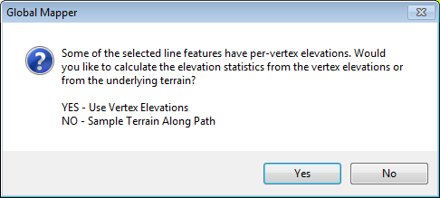
The line feature statistics may either be sampled along the line based on the underlying terrain, or using only per vertex elevation values. If the line feature is 3D and has per-vertex elevations, an additional dialog will specify whether to sample along the line, or use the per vertex elevations for the calculated elevation statistics.

The calculated statistics for line features are as follows:

  • ASPECTClosed— Direction that the slope is facing (i.e. south facing slope is 180, north facing is 0). This is the most commonly occurring slope direction in the line feature.
  • AVG_ASPECTClosed— Average of reported aspects along the line feature. This is the direction the line is sloping (i.e. south facing slope is 180, north facing is 0).
  • AVG_ELEV_M, AVG_ELEV_FTClosed— Average Elevation. Reported in Feet or Meters based on unit settings.
  • AVG_SLOPE_DEGClosed— Average slope angle in reported degrees
  • AVG_SLOPE_PCTClosed— Average slope angle in reported percent rise
  • BEARINGClosed— Average bearing of the line segments, weighted by the length of the segment. This is calculated in relative direction, so for example a line with two segments of equal length at bearing of 350° and 5° would calculate a bearing of 357.5°, not 177.5°.
  • ELEV_GAIN_FT, ELEV_GAIN_MClosed— Total sum of the gain in elevation for all sections that rise in elevation traveling from beginning to end.
  • ELEV_LOSS_FT, ELEV_LOSS_MClosed— Total loss in elevation for all sections that drop in elevation traveling from begging to end of the line feature.
  • LENGTHClosed— Planimetric length of the line feature.
  • LENGTH_3DClosed— Three dimensional length of the line feature.
  • MAX_ELEV_M, MAX_ELEV_FTClosed— Maximum elevation along the line feature.
  • MAX_ELEV_XClosed— X coordinate of the highest elevation point along the line.
  • MAX_ELEV_YClosed— Y coordinate of the highest elevation point along the line.
  • MAX_SLOPE_DEGClosed— the max slope in degrees. The slope is calculated by dividing the rise by the run.
  • MAX_SLOPE_PCTClosed— the max slope percent. The slope percentage is calculated by dividing the rise by the run and multiplying this number by 100. If the value is over 100%, the rise is greater than the run.
  • MAX_UP_SLOPE_DEG, MAX_UP_SLOPE_PCTClosed— Steepest slope when traveling uphill along the length of the from, from start to finish
  • MAX_DOWN_SLOPE_DEG, MAX_DOWN_SLOPE_PCTClosed— Steepest slope when traveling downhill along the length of the from, from start to finish
  • MIN_ELEV_MClosed— Minimum elevation along the line feature.
  • MIN_ELEV_XClosed— X coordinate of the lowest elevation point along the line.
  • MIN_ELEV_YClosed—Y coordinate of the lowest elevation point along the line.
  • STD_DEV_ELEV_M, STD_DEV_ELEV_FTClosed — Standard Deviation of the elevation values with units noted.
  • STD_DEV_SLOPE_DEG, STD_DEV_SLOPE_PCTClosed — Standard deviation of the slope values, in degrees or percent slope.

Point Statistics

The calculated statistics for point features include:

  • ELEVATIONClosed Elevation value at the point based on the underlying terrain raster. The elevation at the point location will be interpolated based on the layer Resampling method (Bilinear Interpolation by default when loading terrain data).
  • MAX_PT_IDX, MIN_PT_IDX Closed— When the point feature is created as a min or max elevation point from area or line features, it will get an index number to indicate which feature it relates to.
  • SLOPEClosed — Slope value based on the underlying raster. For the slope algorithm see Slope Shader Configuration . The slope at the point location will be interpolated based on the layer Resampling method (Bilinear Interpolation by default when loading terrain data).
  • SLOPE_DIRClosed— Direction of the slope reported in cardinal direction (N, S, E, W) and degrees.