Elevations Tab (Vector Data)
The elevations tab sets up the vertical (z value) attributes for the vector features in a layer. The layer settings will be overridden by individual object elevation settings specified in the Modify Feature Info dialog. The layer override the global settings for 3D vector display in the 3D View Properties.
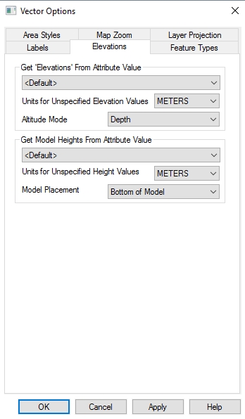
Access the vector Elevations tab from the Control Center, by double clicking on the layer or using the  Layer Options button.
Get 'Elevations' From Attribute Value
Specify the attribute value to apply to feature to define elevation. By default, several attribute
field names (like "ELEVATION", "ELEV", "ALTITUDE",
"Z", etc.) are checked when an elevation value for the feature
is needed. This option allows the user to override this behavior and manually
select the attribute to use.
Units for Unspecified Height Values
Specify units to assign to unspecified elevation values for the layer, such as per-vertex elevation values.
Altitude Mode
Specify what the elevation values are relative to. This impacts the display of vectors in this layer in 3D, relative to other loaded data.
- Unspecified - the altitude mode will be controlled by the 3D View Configuration setting Relation of Vector Data Elevations to Terrain.
- Absolute- The elevation value will be based on 0.
- Relative to Ground- The elevation value will be added to the terrain value
- Clamp to Ground- The vector will be clamped or flattened to the terrain data.
- Depth- The elevation value will be used as a negative number.
Get Model Heights from Attribute Value
This setting specifies the attribute used to designate height values for point features that display with a 3D model for the point symbol. 3D Point Symbols use both an elevation and height value to anchor and scale the model.
The drop-down list will include available attributes, plus an entry for <Default>. If <Default> is chosen, then Global Mapper, when rendering a 3D point symbol, will scan the attributes for one of a small set of candidate attribute names that could work (e.g. "HEIGHT", "DEPTH", "HGT", "HEIGHT"), and if it finds one, will use that. If <Default> is selected Global Mapper will scan the height attribute candidate list. If a specific attribute is used to designate elevation, attribute candidates will be skipped in favor of the user-specified elevation attribute.
Units for Unspecified Height Values
If height units aren't specified in the chosen attribute to use for height values.
Model Placement
3D point symbols are anchored at the elevation value, then they are scaled based on the height value. The model placement defines what part of the model is anchored to the elevation. The available options are:
- Bottom of Model
- Top of Model
- Model Origin
For more information see 3D Point Symbols