GPS Setup
The Setup command displays the GPS Setup dialog (pictured below). The GPS Setup dialog allows you to tell Global Mapper what port your GPS device is connected to your computer on and what format the GPS device is communicating in, and setup an RTK correction source.
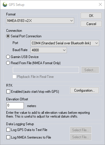
Format
Make sure that you have your GPS device set to NMEA-0183 v2.x or Garmin mode and choose the applicable mode from the Format dropdown menu. Trimble GNSS devices are supported via Bluetooth. The Auto-Detect option directs Global Mapper to automatically determine a GPS device's settings when tracking is started.
Connection
Serial Port Connection - Set the appropriate Port and Baud Rate to connect to the GPS device. Bluetooth connected devices should have the bluetooth link noted next to the COM port in this dropdown menu. If this is not the case you can determine the correct port for a bluetooth connected device by looking in the Windows Bluetooth Settings and noting the Outgoing port for the GPS device.
Garmin USB Device - Select this option if using a Garmin USB connected device.
Read From File (NMEA Format Only) - Use this option and select a file to read GPS information from a text file containing NMEA-0183 sentences. Enable the checkbox to Playback File in Real-Time to show the movement from the recorded data in real-time in the Global Mapper view.
IP Connection (NMEA Format Only) - This functionality requires a GNSS device which has the ability to communicate in this nature. TCP, UDP, and UDP multicast are supported. Please refer to your hardware vendor's documentation for specifics.
RTK (Real-Time Kinematics)
Use the Configuration option to open the Global Mapper NTRIP Client and enter information to connect to an RTK correction source. This requires a Global Mapper Pro license.
|
|
This tool requires Global Mapper Pro |
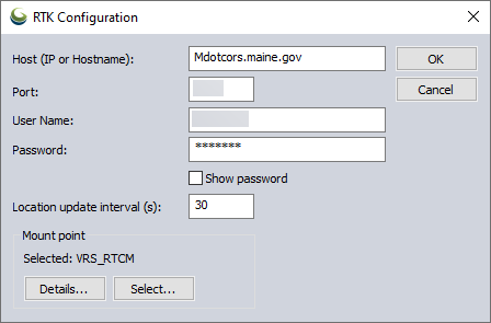
Host Name (IP or Hostname) and Port - Enter the Host Name as a URL or IP address, and enter the port to connect to the source.
User Name and Password - Use your log in information to connect to the NTRIP caster.
Location Update Interval - Set the frequency that location updates will be sent to the NTRIP caster to keep the connection active and maintenance accuracy. Accepted values range from 5 to 300 seconds.
Mount Point - Click Select to choose a specific mount point to receive a correction. Details will show additional information on the selected Mount Point.
Enabled (auto start/stop with GPS) will enable the RTK correction when a connection to a GPS device is established.
Elevation Offset
Enter an elevation offset in meters to be added to the elevation reported by the GPS unit. This will be reflected in the GPS Information and any recorded features.
Data Logging Setup
This section allows the setup logging for incoming GPS information to a text file. You can choose to log decoded position information (including latitude and longitude, elevation/depth, speed, heading, and time) in addition to raw NMEA data strings for connected NMEA GPS devices.
ADVANCED USERS ONLY: By default GPS serial connections use 8-bit, no parity, and 1 stop bit (8N1), but if you have one of the rare units that uses 7-bit rather than 8-bit data streams, there is a way to set that. You need to run 'regedit' and create a DWORD key named 'HKEY_CURRENT_USER\Software\Global Mapper\GPS_ByteSize' with a value of 7 (do this with Global Mapper closed), then your serial connections will use 7-bit mode rather than 8-bit mode.