 Overview Map
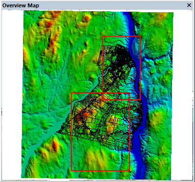
The Overview Map shows the full bounds of the loaded data, similar to a reference map inset in a cartographic map. This can be used both for reference and navigation of the data. The Overview map will show the extent of the 2D map view, i.e. the view boundary, as a rectangle (one for each 2D view if there are multiple map views enabled.) The default style for the view boundaries are red outlines.
The Overview Map may be displayed or hidden using the View > Overview Map menu item or the Overview Map toolbar button on the File toolbar.
It can also be enable from the Configuration Display Options.
The Overview Map is a separate window that can float or be docked.
To change the zoom or extent of the 2D map view, left-click or left-click and drag in the Overview Map. Clicking will move the 2D extent to center on the clicked location. Clicking and dragging on the overview map will change the 2D map view zoom level and extent to match the dragged rectangle. The dragged rectangle will adjust slightly to preserve the aspect ratio of the 2D map view.
Right-click on the overview map to go to the Configuration options that customize the behavior of the Overview Map.
The Overview Map has the following controls:
- Left-click centers the active view at the coordinate under the mouse pointer.
- Left button click-and-drag draws a zoom rectangle, which will be applied to the active 2D map.
- Right-click brings up context menu with the following option: