This tool will adjust the selected lidar point position to move towards the specified terrain surface (Z movement) or trajectory file (X,Y and Z movement), based on a percentage of adjustment. The selected points will be adjusted in position in the existing layer.
Select lidar points with the  digitizer tool, then navigate to Move/Reshape Feature > Adjust Selected Lidar Towards Surface...
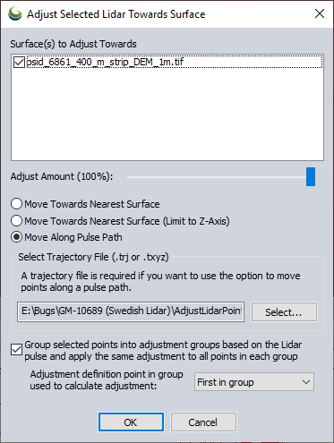
Surface(s) to Adjust Towards
Specify the loaded terrain surface(s) that the points should move towards based on the options chosen in the dialog.
Adjust Amount
The Amount slider decides how much movement towards the surface area the points are to be repositioned, 100 % equals full movement towards surface or trajectory, placing the point on the surface. A value of 50% means that the points will be moved 50 % of the distance towards the surface/ trajectory.
Move Towards Nearest Surface
This will adjust Z value of the selected points to move the specified adjustment amount towards the closest surface. The X and Y values will also be adjusted depending on how angled the surface is that the points are adjusting to.
Move Towards Nearest Surface (Limit to Z-Axis)
This will only adjust the Z value of the selected points to move the specified adjustment amount towards the closest surface.
Move Points Along Pulse Trajectory File (.trj or .txyz)
This option will move the selected lidar points along the line between the Lidar sensor and the point, towards the surface. This calculates the sensor position using the GPS-time and flight-path in a trajectory file. The trajectory file can be a TerraScan trajectory binary file (.trj) or a text file “.txyz”-format. The text file is a tab delimited text file with the following attributes: (GPS-)Time, Easting, Northing and Elevation as point / line vertex attributes.
If this option is selected and multiple surfaces cross the pulse trajectory, movement will be made towards the surface closest to the sensor.
Group selected points into adjustment groups based on the Lidar pulse and apply the same adjustment to all points in each group
With this option checked, the tool will analyze the selected points and group them together based on what lidar pulse they belong to. The adjustment parameters for each adjustment group are calculated based on the selected Adjustment definition point in group used to calculate adjustment drop down menu in the dialog. There are five options to choose from.
Last in Group - the point in each adjustment group furthest away from lidar sensor
First in Group - the point in each adjustment group closest to lidar sensor
Median, Up - the median point in each adjustment group, when there are an even amount of points, the median point closest to the lidar sensor
Median, Down - the median point in each adjustment group, when there are an even amount of points, the median point furthest from the lidar sensor
Average - a calculated point in the center of the adjustment group