S-57 and S-63 Charts
Global Mapper supports S-57 and S-63 vector Electronic Navigation Charts (ENCs). Vector data in these files will be loaded by map scale and display. To change the amount of detail visible in the chart, go to Configuration > Vector Display and adjust the slider for Vector Map Detail.
Load S-57
S-57 files are used by many hydrographic agencies around the world to store vector marine chart data. Load the chart by pointing to the *.000 file, or load the entire zipped directory with a *.tar.gz, *.tgz, *.zip, *.7z extension.
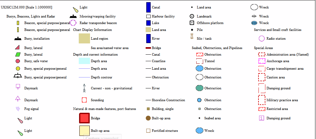
Global Mapper displays S-57 charts utilizing S-52 symbology. A subset of the symbols is displayed below.
The chart can be loaded as one layer, or divided into separate layers based on the S-52 symbol types. A prompt on load will provide these options.
Global Mapper 26.0 and newer support the New Object (NEWOBJ) feature type.
Load S-63
S-63 files are essentially encrypted S-57 charts used by many hydrographic agencies around the world to store vector marine chart data. An S-63 chart is locked to a particular Global Mapper license and can only be loaded by installations using the same license that was used to request the S-63 chart files from the data provider.
To load S-63 charts in Global Mapper, you must first use the File > Create S-63 User Permit File to create a permit file that you provide to the S-63 data provider.
See Create S-63 User Permit File for more information.
The data provider will then provide you with S-63 chart files based on that user permit. You can then load the the .000 file(s) from the provided data set, or if the data was provided in an archive file, simply directly load the .tar.gz or .zip archive.
Global Mapper v11.02 and above can load files in this format. Global Mapper v18.0 and later support S-63 v1.1 files.
Format Updates
Below is a summary of recent changes to format support:
| 26.0 | Added support for "NEW OBJECT" features in s57 (GM-16106) |
| 22.0 | S-52 zoom levels now are used when changing the detail slider on s-57 files. Features that disappear when zooming in will now more closely match the s-52 style [Item #GM-10788] |
| 20.1 | Added S-52 point symbols for s-57 files.[Item #9591] |
| 18.0 | Added support for S-63 v1.1 files. [Item #15562] |
| 16.2 | Improve search for PERMIT.TXT files for S-63 chart files. [Item #15756] |
| 13.2 | Updated S-57 import so that if you have customized the style to use for Isobath areas that style is used rather than an auto-assigned solid shade of blue based on depth. |
| 13.1 | Updated S-57 to support inland waterways types. |
| 13.1 | Updated S-57 and S-63 ENC imports to list the chart scale as part of the layer description and provide all of the chart header information as attributes listed as part of the Metadata for the chart. |
| 12.0 | Made attributes for S-57/S-63 files include both the raw value and the associated text for that value (if known), rather than just the associated text if known. |
| 11.2 | Added support for loading S-63 (encrypted S-57 charts) format files. Use File->Create S-63 User Permit menu command to generate a user permit file to provide to S-63 data provider to obtain S-63 files encrypted for use with your Global Mapper installation. |
| 11.1 | Removed warnings about unknown attributes during S-57 imports. |
| 11.1 | Added support for reading annotation and traffic line features from S-57 (ENC) files. |