NITF
Loading NITF files
NITF files can be loaded by selecting the *.NTF file, or loading a zipped file that contains the data. NITF files contain two types of geolocation information, so the dialog will appear to specify which type to use.
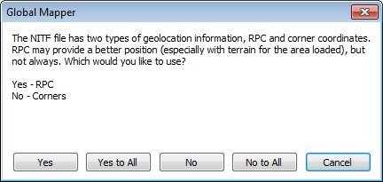
RPC positioning uses a set of control points, which will be converted using latitude, longitude and height. The height conversion is done using average height for the scene, or if elevation data is loaded, it will query the elevation value at the control point location.
Alternately the scene can be positioned from the corners. Select no to use the corner positions.
Exporting NITF files
The Export NITF command allows the user to export any loaded raster, vector, and elevation grid data sets to a NITF (National Imagery Transmission Format) file.
When selected, the command displays the NITF Export Options dialog which allows the user to setup the export. The dialog consists of a General options panel which allows the user to set up the pixel spacing, a Tiling panel, and an Export Bounds panel which allows the user to set up the portion of the loaded data they wish to export.
The NITF exports requires the WGS84 datum and will always use the UTM zone or Geographic Latitude/ Longitude as the projection. If the current projection is UTM, it will automatically switch to that UTM zone with WGS84 datum. Otherwise it will switch to a Geographic Projection WGS84 datum.