Blue Marble Gridded Data
The Blue Marble GriddedDdata (.bgd) format is used to create custom geoids for the Geographic Calculator application. Once the elevation grid/custom geoid has been exported as a BGD file and added to the Geographic Calculator application as a new, custom vertical transformation, this will be available when selecting a Coordinate Transformation in Geographic Calculator.
Load the elevation grid data into Global Mapper. Then, go to File > Export Elevation Grid Format... and in the 'Select Export Format menu, select 'Blue Marble Gridded Data' from the drop down menu.
The Blue Marble Gridded Data Export Options dialog will populate.
Specify the Vertical Units for the output geoid grid using the dropdown.
Specify the Resampling method to use to calculate the output grid.
- NEAREST_NEIGHBOR - use the nearest neighbor sampling method
- BILINEAR - use bilinear interpolation
- BICUBIC - use bicubic interpolation
- BOX_2X2 - use a 2x2 box average
- BOX_3X3 - use a 3x3 box average
- BOX_4X4 - use a 4x4 box average
- BOX_5X5 - use a 5x5 box average
- BOX_6X6 - use a 6x6 box average
- BOX_7X7 - use a 7x7 box average
- BOX_8X8 - use a 8x8 box average
- BOX_9X9 - use a 9x9 box average
- MAX_2X2 - use maximum value found in 2x2 box (for image layers, use brightest color)
- MAX_3X3 - use maximum value found in 3x3 box (for image layers, use brightest color)
- MAX_4X4 - use maximum value found in 4x4 box (for image layers, use brightest color)
- MAX_5X5 - use maximum value found in 5x5 box (for image layers, use brightest color)
- MAX_6X6 - use maximum value found in 6x6 box (for image layers, use brightest color)
- MAX_7X7 - use maximum value found in 7x7 box (for image layers, use brightest color)
- MAX_8X8 - use maximum value found in 8x8 box (for image layers, use brightest color)
- MAX_9X9 - use maximum value found in 9x9 box(for image layers, use brightest color)
- MED_2X2 - use median value found in 2x2 box
- MED_3X3 - use median value found in 3x3 box
- MED_4X4 - use median value found in 4x4 box
- MED_5X5 - use median value found in 5x5 box
- MED_6X6 - use median value found in 6x6 box
- MED_7X7 - use median value found in 7x7 box
- MED_8X8 - use median value found in 8x8 box
- MED_9X9 - use median value found in 9x9 box
- MIN_2X2 - use minimum value found in 2x2 box (for image layers, use darkest color)
- MIN_3X3 - use minimum value found in 3x3 box (for image layers, use darkest color)
- MIN_4X4 - use minimum value found in 4x4 box (for image layers, use darkest color)
- MIN_5X5 - use minimum value found in 5x5 box (for image layers, use darkest color)
- MIN_6X6 - use minimum value found in 6x6 box (for image layers, use darkest color)
- MIN_7X7 - use minimum value found in 7x7 box (for image layers, use darkest color)
- MIN_8X8 - use minimum value found in 8x8 box (for image layers, use darkest color)
- MIN_9X9 - use minimum value found in 9x9 box (for image layers, use darkest color)
- BLUR_3X3 - perform a Gaussian Blur using 3x3 kernel
- BLUR_5X5 - perform a Gaussian Blur using 5x5 kernel
- BLUR_7X7 - perform a Gaussian Blur using 7x7 kernel
Sample Spacing
The Sample Spacing section allows the user to select the grid spacing to use when generating the file. The default value is the average of the grid spacings of all the currently loaded raster and elevation overlays.
If the Always Generate Square Pixels option is checked, the smaller of the specified x and y resolutions will be used for both the x and y resolution.
Selecting Always Generate Square Pixels ensures that the resultant image file will look good even in software that is not able to deal with pixels that aren't square.
To specify the spacing in units other than those of the currently selected view/ export projection, press the Click Here to Calculate Spacing in Other Units button.
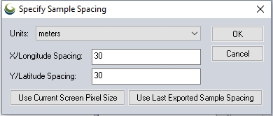
Specify the X and Y spacing of the output pixels in any of the selected units. These pixel dimensions will be translated into the units of the display projection during export. The Use Current Screen Pixel Size button will update the X and Y values to the dimensions of the map display. Use Last Exported Sample Spacing will update the X and Y values to the most recent export resolution.
Interpolate to fill small gaps in data
Any small areas with missing data will be filled in by interpolating the surrounding valid data using an IDW method. This is useful for filling small gaps between adjacent tiles or small holes in elevation data.
Generate PRJ (Projection) File
Check this option to generate an external prj file for the BGD. Geographic Calculator and Global Mapper do not require this file to read the projection for the BGD file.