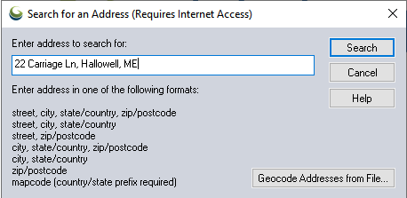
The Find Address command displays the Search for an Address dialog (pictured below) which allows searching for an address, city, postal code or mapcode anywhere in the world.
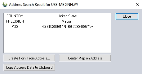
If an address is found that matches the requested location, a results dialog (see sample below) is displayed with the matching location information, as well as button to allow creating a new point feature at the address location, re-centering the map view on the address, and copying the address information to the Windows clipboard for easy pasting into another application.

Batch Geocoding
The dialog also includes a Geocode Addresses from File button that allows you to geocode a bunch of addresses at once. The text file that you select to convert can either contain a list of files with addresses in the single line form accepted when searching on a single address, or it can be a comma or tab-delimited file with named columns, like Address, City, State, Country, and Zip or Postcode (see the example file contents below).
Example
Sequence,Name,Address,City,State,ZIP,Phone
1,McPeak Betty,,North Pole,AK,99705,907-488-4879
2,McPeak P,,Anchorage,AK,99501,907-770-2957
3,McPeak Roger,,North Pole,AK,99705,907-488-8823
4,McPeak Allan,1011 McCay Ave,Mobile,AL,36609,251-633-0931
5,McPeak Bill,395 Dupree Dr,Huntsville,AL,35806,256-837-2657
6,McPeak Carol,5923 Lumsden Battery Cir,Mobile,AL,36619,251-661-0989
7,McPeak Dwight,5548 Heath Row Dr,Birmingham,AL,35242,205-991-8862
8,McPeak Faye,146 Larkin St,New Market,AL,35761,256-379-5416
9,McPeak Faye,395 Dupree Dr,Huntsville,AL,35806,256-837-2657
Batch Geocode Setup
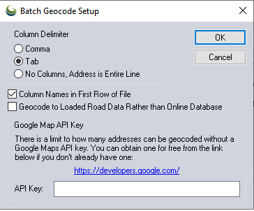
Column Delimiter - Specify the field delimiter used in the text file.
Column Names in First Row of File - Check this option if the loaded file contains a header row.
Geocode to Loaded Road Data Rather than Online Database
When batch geo-coding, you can choose to either geocode US addresses against an online database, or to geocode to loaded road data instead. If you choose to geocode against loaded road data, you must already have road data loaded with a known address format, like Tiger/Line data in the US, or data with supported attribute names for addressing information, like R_FROM_ADR, L_TO_ADR, R_FROM_CITY, L_TO_CITY, etc., so that the data can be geocoded.
By default, the online geocoder will reach out to the Azure Maps API, but users can provide their own Google Maps API key as well. Without a user-specified Google Maps API key, address searches within a single 24 hour period are limited. See https://developers.google.com/maps/documentation/geocoding/get-api-key for more information on obtaining a Google Maps API key.
Google Map API Key - If you would like to geocode thousands of addresses at a time, it is necessary to obtain a Google Maps API key. Enter the API key in the dialog, and it will be added to the geocode request. See https://developers.google.com/maps/documentation/geocoding/get-api-key for more information.
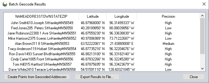
Batch Geocode Results
Once you complete a batch geocode operation, the results are displayed in a list in a dialog (see sample below). The Batch Geocode Results dialog contains buttons allowing you to create new point features from the matched address results or to export the results to a new file.
Mapcode
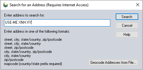
To search by mapcode, rather than long form address
simply enter the mapcode into the search address field.
The mapcode
system is an international standard that allows any location on the
surface of the Earth to be represented by a short 'code', typically composed
of 4 to 7 letters and digits. The short mapcode will usually bring you
within a few meters of the location, though as with street addresses positional
accuracy can vary. Once searched by, the search results window will populate
with a coordinate position for the mapcode.
The mapcode system is particularly helpful for mapping in locations where
a street address database has not been built, or in rural areas where
street names are non-specific.
In addition to the mapcode, input the country and state, province or territory
abbreviation. For example, the mapcode 'XNH.VY' located in the state of
Maine, in the United States would be expressed using the format below.
USA-ME XNH.VY