The Alter Elevation Values tab (pictured below) allows the user to modify how elevation values from the selected layer(s) are interpreted, providing you a means to offset all of the elevations in the layer(s) by a given value and to restrict the range of elevation values that are treated as valid.
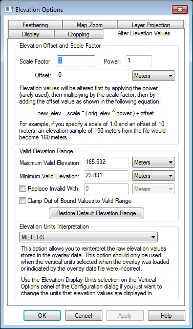
Elevation Offset and Scale Factor
Apply a modification to the elevation values using a scale factor, power, or offset.
A power will apply an exponential scaling to the elevation values, so the slopes will exaggerate as the elevation increases.
A scale factor will by multiplied by all elevation values. Common example would be a scale factor of -1 to convert depth data to negative heights, or a vertical exaggeration or conversion value.
An offset value will be added to all elevation values in the layer. Some examples of applying a layer offset may be to fine tune sources to agree with each other, or to artificially offset layers for 3D viewing.
Valid Elevation Range
Specify the Minimum and Maximum elevation values to display for the layer. Pixels outside of the valid elevation range will be replaced with a no data value (i.e. transparent) unless a below option is specified.
The Replace Invalid With a number setting will replace all no data pixels in the layer or out of the Minimum Maximum elevation range with the specified elevation value.
The Clamp Out of Bound Values to Valid Range setting will replace all values outside of the specified elevation range with the minimum or maximum.
Select the Restore Default Elevation Range button to reset the minimum and maximum elevation values based on the original input data statistics.
Elevation Units Interpretation
Specify the unit interpretation for the elevation or Z values in the layer. When a vertical unit is not specified in the input file format, the default elevation unit interpretation will be to match the horizontal unit of the layer projection. When the horizontal coordinate system is not in linear units, or in other cases where there can be no inference made about the elevation unit, the default elevation unit interpretation is Meters.