Global Mapper can import and export text files containing a variety of formats.
Import Text File
Text files can be opened using the Open Generic Text File option in the File Menu. They may also be opened with the open data options, which will provide the same Generic Text File Import Options dialog.
The automatically recognized text file extensions include:
*.asc, *.bln, *.bna, *.csv, *.dat, *.gcp, *.ldb, *.pts, *.txt, *.txyz, *.xyz, *.xyzi, *.xyzt, *.xyz.gz
Or change the filter to All Files to load a file with any extension as a text file.
Text files that do not contain coordinates can be appended to related vector features by Joining a Table.
Export Text File
The Export XYZ Text commands allows the user to export any loaded vector data sets to an XYZ Text format file. 3D Mesh features will also be converted to 3D Vectors and included in the exported data.
The following export menu options export a text file:
- Text File
- Simple ASCII (XYZ) Test File
- XYZ (Simple ASCII) Text File
- CSV
- XY Color
- XY Harris Multilayer
Export loaded vector data to a csv file from the File > Export > Export Vector/Lidar Format... option, or by right-clicking on a specific layer in the Control Center. Go to Layer > EXPORT and choose Text File, Simple ASCII (XYZ) Text File or XYZ (Simple ASCII) Text File as the export format. Multiple files can be batch converted to and from the format from the Batch Convert/Reproject tool.
When selected, the command displays the ASCII Export Options dialog .
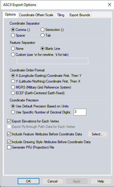
Coordinate Separator
Specify the delimiter used to separate values in the output file.
Feature Separator
Use the custom option to specify a character or set of characters that will separate each vector feature in the file. Otherwise features can be separated by a blank line, or no explicit separator.
Coordinate Order / Format
Specify the output coordinate order. The default would create X,Y,Z values. There are also options for listing the Y/Latitude/Northing value first, or export MGRS![]() Military Grid Reference System is a NATO coordinate system standard that references points by grid zone, then 100,000 meter square identifiers, then numerical location in easting and northing. For more information see https://www.bluemarblegeo.com/knowledgebase/calculator/Content/Military_Grid_Reference_System_(MGRS).htm or ECEF
Military Grid Reference System is a NATO coordinate system standard that references points by grid zone, then 100,000 meter square identifiers, then numerical location in easting and northing. For more information see https://www.bluemarblegeo.com/knowledgebase/calculator/Content/Military_Grid_Reference_System_(MGRS).htm or ECEF![]() Earth Centered Earth Fixed Coordinates are a coordinate system with the origin at the center of the earth. For more information see https://www.bluemarblegeo.com/knowledgebase/calculator/Content/XYZ_Cartesian_Earth_Centered_Earth_Fixed.htm coordinates.
Earth Centered Earth Fixed Coordinates are a coordinate system with the origin at the center of the earth. For more information see https://www.bluemarblegeo.com/knowledgebase/calculator/Content/XYZ_Cartesian_Earth_Centered_Earth_Fixed.htm coordinates.
Coordinate Precision
Use the default coordinate precision, which is typically 3 decimal places for planar units, or specify an explicit decimal precision for the output coordinates.
Export Elevations for Each Vertex
Check this option to include the Z value for each vertex following the X,Y coordinates.
Export Fly-through Path Data for Each Vertex
If the exported features include lines that contain per vertex fly-through attributes such as Time, Velocity, Heading, Pitch and Bank check the option to include these per vertex attributes in the export.
Include Feature Attributes Before Coordinate Data
If this is not checked, only coordinate and label values will be exported. When checked, selected attribute values will be included in the export, even if all of the attribute values are blank. The default is for all attribute values to be included. Press the Select... button to choose a subset of attributes to include.
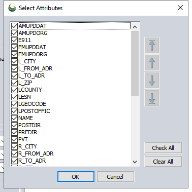
Press the Check All or Clear All buttons to bulk select or deselect attributes. Use the arrow buttons to change the order of attributes in the exported file. The arrow with the underline will move the highlighted attribute to the bottom or top of the list.
Include Drawing Style Attributes Before Coordinate Data
Check this option to add attributes with the style information before the coordinate data.
Generate PRJ File
A PRJ file describing the projection of the coordinates in the file will automatically be created .
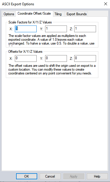
Coordinate Offset / Scale
The Coordinate Offset/Scale tab (below) contains options to set Scale Factors and Offsets for X/Y/Z coordinate values.
Format Updates
Below is a summary of recent changes to text format support:
| Version | Description |
|---|---|
| 21.1 | Fixed issue with text and attributes being corrupted when combining lines when the layer code page is different than the system code page and non-ASCII text is used.[Item #GM-10520] |
| 21.1 | Specify which attributes to include and attribute order when exporting to CSV, text and vector XYZ files. [Item #GM-10745] |
| 21.0 | [Scripting] Updated the EDIT_MAP_CATALOG script command to support parameters from the IMPORT_ASCII command when adding generic text files to the catalog.[Item #GM-10294] |
| 20.1 | Fixed loss of text when creating areas from lines or lines from areas with labels and/or attributes in a code page other than the system code and non-ASCII characters.[Item #26324] |
| 20.0 | Added the ability to remember coordinate column names when importing ASCII files and use them during export.[Item #24350] |
| 20.0 | [Scripting] Updated position parameters for script commands to support lat/lon coordinates in addition to current projection values. This includes XMIT_POS for GENERATE_VIEWSHED, START_POS and END_POS for GENERATE_PATH_PROFILE, and START_POS for IMPORT_ASCII.[Item #23509] |
| 19.0 | Flythrough paths can now be imported and exported from several formats including GPX, KML, and ASCII text. |
| 19.0 | Can now export fly-through path data to XYZ text file, and import as Generic ASCII text file.[Item #22144] |
| 18.1 | Fixed issue with ELEVATION attribute not showing up for XYZ point files loaded with File->Open Text File. [Item #19772] |
| 17.2 | Renamed Open Generic ASCII Text File menu command to just Open Generic Text File to better reflect the commands support for non-ASCII text files, including Unicode and UTF-8 encoded files. [Item #17610] |
| 17.2 | [Scripting] Added support for creating a distance/bearing/COGO line using the IMPORT_ASCII command. Use TYPE=DIST_BEARING_LINE to create a line from the series of segment lengths and bearings rather than a series of points. You can also add TYPE=DIST_BEARING_SEGS to create a separate 2-point line for each dist/bearing line. The line connects the START_POS to the point created at the end. You can also now specify START_POS=”SELECTED” to use the position of a selected point feature as the start location. [Item #17752] |
| 17.1 | Improved load of Lidar point clouds from generic ASCII text files. Additional column layouts are recognized, including XYZI, XYZRGB, and XYZIRGB. In addition, if the file has named columns, any column layout works as long as it has recognized column names, like RED, GREEN, BLUE, INTENSITY, NIR, etc. [Item #16811] |
| 17.1 | Fixed join of attributes to a vector layer from a text file encoded using UTF-8 when non-ASCII characters are present. [Item #17220] |
| 16.2 | Fixed error in v16.1.0-v16.1.1 using the IMPORT_ASCII script command with no TYPE parameter. It should default to TYPE=POINT_AND_LINE if not provided. |
| 16.2 | Updated simple ASCII text (XYZ vector) export to allow creating files over 2GB in size. [Item #15517] |
| 16.2 | Updated simple ASCII text (XYZ vector) export to allow creating files over 2GB in size. [Item #15517] |
| 16.1 | Support use of R, G, and B columns as color in a generic ASCII text file being loaded as a Lidar point cloud. |
| 16.1 | Made generic ASCII text import with ‘Auto-Detect’ or ‘Space or Tab’ delimiter prefer tab over space so that tab-delimited files with spaces in the coordinate fields can be correctly loaded without having to select ‘Tab’ explicitly. |
| 16.1 | Save some settings on the Generic ASCII import dialog between runs, such as coordinate order, import type, and coordinate prefix. |
| 16.1 | Made generic ASCII text import with ‘Auto-Detect’ or ‘Space or Tab’ delimiter prefer tab over space so that tab-delimited files with spaces in the coordinate fields can be correctly loaded without having to select ‘Tab’ explicitly. |
| 16.0 | Fixed handling of attributes for generic ASCII text files when breaking new features on the change in the value in a particular column. Before the first line of attributes from the next feature could be added to a feature. In addition attributes with different values were added as separate attributes rather than combined in one. |
| 16.0 | Added support for specifying what Z value is treated as the no-data (void) value when loading ASCII files with the 3rd coordinate value treated as the Z (elevation) value. This allows no-data values other than the default of -999999.0. |
| 16.0 | [Scripting] Added option to specify what elevation value is the no-data (void) elevation by adding VOID_ELEV to the IMPORT_ASCII script command. |
| 15.2 | Remove quotes automatically from attribute values in generic ASCII text file import. |
| 15.2 | Added support for LogASCII well files with the lat/lon stored in a FL1 field. |
| 15.2 | Added support for exporting loaded 3D areas and terrain layers to ASCII AVS UCD files. |
| 15.2 | Added option to export the Y/Latitude coordinate before the X/Longitude coordinate when batch converting to Simple ASCII Text, XYZ Grid, and XY Color files. |
| 15.2 | Added option to write out ECEF coordinates when exporting to CSV and Simple ASCII Text format. |
| 15.2 | Added support for exporting loaded 3D areas and terrain layers to ASCII AVS UCD files. |
| 15.2 | Added option to export the Y/Latitude coordinate before the X/Longitude coordinate when batch converting to Simple ASCII Text, XYZ Grid, and XY Color files. |
| 15.1 | Fixed error saving a workspace with modified ASCII text files that contained areas. |
| 15.1 | [Scripting] Added support for importing text files with a per-vertex time column using the IMPORT_ASCII command with a custom COORD_ORDER parameter describing where the time column is located. |
| 15.1 | [Scripting] Added support for adding USE_CENTER_COORDS for ARCASCIIGRID export with EXPORT_ELEVATION script command. |
| 15.1 | [Scripting] Added support for adding vector features from inside a script by using a new DEFINE_TEXT_FILE command which allows embedded text descriptions of features right in the script and then loading with IMPORT_ASCII. |
| 15.1 | Fixed error saving a workspace with modified ASCII text files that contained areas. |
| 15.0 | Added support for loading text files with the coordinates stored as ECEF (Earth-Centered Earth-Fixed) coordinates. The Coordinate Format drop-down on the ASCII Text Import dialog has an option to specify that the coordinates are ECEF. |
| 15.0 | Updated generic ASCII text import where attributes from coordinate lines are kept and lines are broken based on the change in some field to add the break attribute to the attribute list for the line feature. |
| 15.0 | Fixed encoding of non-ASCII folder names in KML/KMZ files. |