Erdas Imagine
The ERDAS Imagine Image format is the raster data format used with the ERDAS Imagine software product line.
Import
Typical imagery includes satellite data as well as land coverages. For multi-band images and grayscale images, Global Mapper will automatically apply a two-standard deviation contrast stretch in order to generate an aesthetically pleasing image with no intervention. If present, the first 3 bands will be used the generate the image, with band 1 being red, band 2 being green, and band 3 being blue.
Export
The Export Erdas Imagine command allows the user to export any loaded raster, vector, and elevation grid data sets to an Erdas Imagine file.
Export Erdas Imagine files from the File> Export menu by choosing Export Elevation Grid Format... or Export Raster/ Image Format.... and specifying Erdas Imagine file as the Export Format. Individual layers can also be exported from the Control Center by right-click on the layer and going to Layer > EXPORT. Multiple files can be batch converted to and from the format from the Batch Convert/Reproject tool.
When selected, the command displays the Erdas Imagine Export Options dialog which allows the user to setup the export.
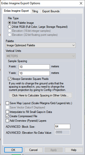
The dialog consists of a General options panel which allows the user to set up the pixel spacing and format, a Tiling Panel, and an Export Bounds panel which allows the user to set up the portion of the loaded data they wish to export.
File Type
- 8-bit Palette Image - This option generates a 256-color raster file with 8-bits per pixel. The Palette options described below will apply in this case. This option will generate a relatively small output file, at the expense of some color fidelity depending on the palette that you choose. The image data will be compressed using the PackBits compression algorithm.
- 24-bit RGB - This option generates a raster file with 24-bits per pixel. Uncompressed images generated with this option will be at least 3 times the size of those generated with the 8-bit Palette option, but the colors in the image will exactly match what you see on the screen.
- Elevation (16-bit integer samples) - This option generates an elevation grid using the currently loaded elevation grid data sets. Elevation samples will be stored as signed 16-bit integers.
- Elevation (32-bit floating point samples) - This option generates an elevation grid using the currently loaded elevation grid data sets. Elevation samples will be stored as 32-bit floating point values.
Palette
When generating a 8-bits Palette image, it is necessary to select a palette indicates what 256 colors will be used to describe the image being exported.
For more information on available palettes see GeoTIFF
Vertical Units
The Vertical Units field allows the user to select the vertical units to use when exporting elevation data (i.e. meters or feet). Any input data not in the selected vertical units will be automatically converted on export.
The Sample Spacing section allows the user to select the grid spacing to use when generating the file. The default value is the average of the grid spacings of all the currently loaded raster and elevation overlays.
If the Always Generate Square Pixels option is checked, the smaller of the specified x and y resolutions will be used for both the x and y resolution.
Selecting Always Generate Square Pixels ensures that the resultant image file will look good even in software that is not able to deal with pixels that aren't square.
To specify the spacing in units other than those of the currently selected view/ export projection, press the Click Here to Calculate Spacing in Other Units button.
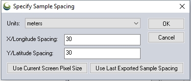
Specify the X and Y spacing of the output pixels in any of the selected units. These pixel dimensions will be translated into the units of the display projection during export. The Use Current Screen Pixel Size button will update the X and Y values to the dimensions of the map display. Use Last Exported Sample Spacing will update the X and Y values to the most recent export resolution.
Save Map Layout
The distance scale, elevation legend, and coordinate grid will be saved to the file (except when exporting elevation grids) if they are configured to show up in the main display.
Save Vector Data if Displayed
Any loaded vector data that is configured to show up in the main display will be saved to the image file (except when exporting elevation grids).
Interpolate to fill small gaps in data
Any small areas with missing data will be filled in by interpolating the surrounding valid data using an IDW method. This is useful for filling small gaps between adjacent tiles or small holes in elevation data.
Create Compressed File
Compression will decrease the file size when the file contains large homogenous areas.
Add Overview (Pyramid) Layers
Large images will render faster across applications if they also have pyramid layers generated.
ADVANCED: Block Size
ERDAS files contain an internal tilling, specified as a block size. The default and most common block size is 64 pixels. For more information see https://community.hexagongeospatial.com/t5/ERDAS-IMAGINE-Q-A/ERDAS-IMAGINE-img-Files/ta-p/704
ADVANCED: Elevation No-Data Value
Customize the no-data value when exporting an elevation grid format.
Format Updates
Below is a summary of recent changes to Erdas Imagine export:
| Version | Description |
|---|---|
| 21.0 | Added support for customizing the no-data value for Erdas Imagine and GeoTIFF elevation exports, both through the UI and using the VOID_ELEV parameter for the EXPORT_ELEVATION script command.[Item #18759] |
| 19.1 | Fixed issue with some high-bit-depth Erdas Imagine IMG files displaying fully transparent when loaded as image.[Item #23567] |
| 17.2 | Fixed issue with elevation units being always assigned as meters for Erdas Imagine .img grids loaded from map catalogs or workspaces. [Item #17472] |
| 17.1 | Fixed error drawing ECW, JPEG2000, Erdas IMG, and MrSID layers with contrast adjustment (i.e. high bit depth layers) in v17.0.0-v17.0.1.Item #16528] |
| 16.2 | Support reading elevation units from Erdas IMG files that include that information. If present those files are also automatically interpreted as elevation rather than prompting the user. The vertical datum is also added to the layer metadata as a VERT_DATUM value if present. [Item #15717] |
| 16.2 | Added support for reading and writing WKT PRJ strings for Erdas Imagine IMG files, allowing more projections to be automatically handled. [Item #15657] |
| 16.2 | Fixed issue with contrast adjustment for some Erdas Imagine IMG multi-band files not applying correctly to bands other than the first 3. [Item #15487] |
| 15.0.0 | Updated Erdas Imagine IMG files to automatically obey any no-data values specified in the header, both for terrain grid and imagery files. |