The Area Styles section of the Configuration menu allows the user to configure how areas of a given type will be displayed in Global Mapper.
Access the Area Styles by selecting the  Configuration button from the File Toolbar or Tools menu, and navigating to the Area Styles section in the Styles folder.

Area Type
See Built-In Area Types and Styles for a graphical reference guide to the area types and border/ fill styles built-in to Global Mapper.
Context Menu
New Type...
Add a new point type and specify its symbology and labeling.
Edit Type...
Choose this option to edit name and symbol for the selected type. Built in types can not be renamed, but the symbols and labeling for the type can be modified using the sections below.
Delete Type
Delete the selected Feature Type. Custom point types are also specified in a text file in the user data folder. Built-in types can not be deleted.
Attributes...
Specify attributes that will be automatically assigned to new features created as the selected type. Default values can also be specified. For more control over possible attribute values, see Feature Templates.
Fill Pattern
Specify the fill pattern for the selected Area Type.
Color
Specify the color of the fill.
Add Custom Fill Pattern...
This option provides the opportunity to create a custom fill pattern from an image file. For transparent or translucent patterns, use a transparent PNG format image file when creating the custom fill pattern.
Delete Fill Pattern
Delete the selected fill pattern. Built-in fill patterns can not be deleted.
Random Color from Palette
Check the Use Random Styling box to enable this feature for the Unknown Feature Style types.
The Select Palette button allows customization of the 12 colors that are used at random for styling Unknown Area Features.
- Note: for all feature types other than "unknown", this button is not active.
Border Style
Specify the Border style, color and width for the selected Area Type.
For more information on line styles, see Built in Line Styles.
The width of the line can be specified in various units:
- Pixels — Specify the size in pixels in the screen.
- Meters (Fixed-width, Ground) — A width specified in ground units will enlarge as the map is zoomed.
- Millimeters (Fixed-width, Device)— A width specified in millimeters will maintain this thickness both onscreen and when printed.
Transparency
With the Transparency slider, users can make solid filled areas partially see-through (translucent) in order to see data underneath the area.
Check this option to label features of this type by default. The default label is the Feature Name attribute.
Select Label Font...
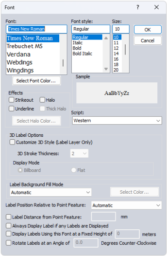
This opens a dialog for configuring the label properties for the Feature, including Font, background, relative position, size, and rotation.
Font
Select the font to use for the label. The list will populate with available system fonts. See also Labels Configuration for default font face and character set.
Effects
Specify text effects, including a halo around the text, halo color and thickness, a specific font color, or strikeout and underline effects.
Script
Specify the script to use for the label. The available options are dependent on the selected font.
3D Label Options
Check the box to enable 3D Label Style customization. These changes will only be applied to labels within a Label Layer.
3D Stroke Thickness determines the thickness of the text background for labels displayed in 3D.
Label Background Fill Mode
Specify how to fill the background for the labels. This setting is overridden by a halo effect.
- Automatic: In most cases this will use a transparent background to the label text
- Opaque - Background Color : Label text box will use the specified background color of the workspace.
- Transparent: No text box fill color for the label.
- Opaque- Custom Color: Use the select color... button to select a custom background text box fill color.
Label Position Relative to Point Feature
Specify how the label is placed relative to the point anchor. The Automatic setting will relocate labels with movement and zoom in order to declutter and reduce label overlap.
Label Distance from Point Feature
When this option is checked, the specified number will be used to calculate the distance away from the label anchor point in pixels based on the current screen resolution. Zero is a valid entry. When the option is not checked, the padding will be calculated as 1/8 of the font height.
Always Display Label if any Labels are Displayed
Objects with this label setting checked will maintain priority during label decluttering.
Display Labels using this Font at a Fixed Height in Meters
Use this setting to specify labels in a size relative to a ground unit size, rather than a font size. The labels will shrink and grow when zooming, to always maintain the same geographic scale. This setting can be particularly useful for reference features, such as labels of background area boundaries.
Rotate Labels
Specify the angle to rotate the labels. (This setting is only available for point and area feature labels.)
Restore Default Style
This button will restore the default style for the selected Point Type.
Restore Default Style for All Types
This option will restore the default styles for all Point Types.