Shader Options
The Shader Options section of Configuration controls options for the display of elevation data using the daylight, gradient, slope, and HSV shaders, as well as editing of Custom Shaders. Shaders are the color ramp or color steps that are applied to visualize terrain data by elevation value, slope or slope direction.
Access the Shader Options by selecting the  Configuration button from the File Toolbar or Tools menu, and navigating to the Shader Options section.
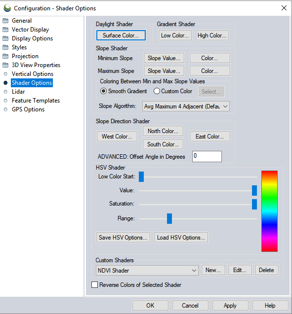
Surface Color
Sets the calculated
surface intensity color.
Low Color Start (Advanced)
Sets where in the HSV color range the lowest elevation will be.
Value
Modifies the HSV value parameter.
Saturation
Modifies the HSV saturation parameter.
Range
Modifies how much of the full HSV range is to be used. Increasing this value leads to color wraparound.
Save HSV Options...
Save the current HSV options in a text file.
Load HSV Options...
Load a set of HSV options from a text file. Loading the options will change the sliders and the preview image, but will not be activated in GM until clicking the OK or Apply button.
Minimum Slope
Slope Value
Allows the user to set the slope at or below which the Minimum Slope Color is used.
Color
Specifies the color which all parts of the terrain with a slope at or below the Minimum Slope Value will be colored with.
Maximum Slope
Slope Value
Allows the user to set the slope at or above which the Maximum Slope Color is used.
Color
Specifies the color which all parts of the terrain with a slope at or above the Maximum Slope Value will be colored with.
Coloring Between Min and Max Slope Values
Smooth Gradient
Specifies that all portions of the terrain with a slope between the Minimum Slope Value and the Maximum Slope Value will be colored with a smooth gradient of colors that vary with the slope from the Minimum Slope Color to the Maximum Slope Color.
Custom Color
Specifies that all portions of the terrain with a slope between the Minimum Slope Value and the Maximum Slope Value will be colored with a single color that can be modified with the Select... button.
Slope Algorithm
Specify the neighborhood operation used to calculate the slope values. The slope value is calculated at a given pixel location based on the elevations in the surrounding pixels. The algorithm choice defines the size of the moving window used and the statistic.
The choices are:
- Avg Maximum 4 Adjacent (Default) - calculates the average slope in a 3 X 3 circle surrounding the pixel (not including indirect neighbors connected by the corners, i.e. Rook's case).
- Avg Maximum 8 Adjacent-calculate the average slope in a 3 X 3 square surrounding the pixel, including all direct and indirect neighbors (i.e. Queen's case).
- Maximum 4 Adjacent- calculates the maximum slope in a 3 X 3 circle surrounding the pixel (not including indirect neighbors connected by the corners, i.e. Rook's case)
- Maximum 8 Adjacent-calculate the maximum slope in a 3 X 3 square surrounding the pixel, including all direct and indirect neighbors (i.e. Queen's case).
East Color
Set the color to use for slopes facing directly East.
North Color
Set the color to use for slopes facing directly North.
South Color
Set the color to use for slopes facing directly South.
West Color
Set the color to use for slopes facing directly West.
ADVANCED: Offset Angle in Degrees
Specify
an angle offset in degrees to add to the calculated slope direction
in order to shade against slope directions other than cardinal directions.
Shaders control exactly how elevation data is rendered in terms of how pixel values relate to colors. Custom Shaders allow the user to determine color in relation to specific ranges of elevation or slope values. Custom Shaders are saved in the Global Mapper workspace and, once created, can be edited in the Configuration menu.
To create a new shader, click Add and enter a value in the Height/ Slope entry field, and specify the color associated with that value. The chosen swatch and value will be displayed in the Elevation/ Slope Colors list.
The Preview on the right side will show the shader color ramp, with a cross bar representing the location of the specified values. Check the Blend Colors Between Elevation/ Slope values option to create a continuous shader, or deselect it to create a classified shader.
To edit an existing custom shader, navigate to the Edit... button in Configuration Shader Options Custom Shader section.
The Delete button in Configuration Shader Options removes the currently selected custom shader.
Pressing the New... button displays the Custom Shader dialog (pictured below) which allows the user to create a new custom shader. New shaders can also be created from the Add Custom Shader...option on the Shader drop-down in the Viewer toolbar, or the Custom Shaders button on the Dynamic Hill Shading tool.
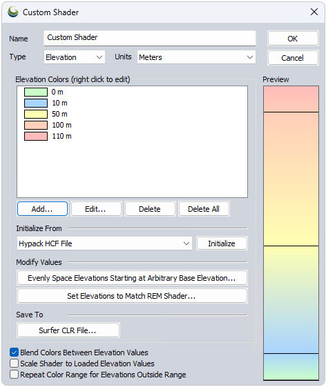
The Custom Shader dialog specifies a custom elevation data color palette, and the relationship to the pixel values.
Name
The Name field provides a place to enter the name to associate with the shader to allow the user to select it. The Elevation Colors section display the elevations and their color values associated with the custom shader.
Type
Choose to create the shader based on Elevation values, or Slope values.
Units
Changes based on Type. This determines the units that the shader is created with. It does not need to reflect the native units of the shaded or displayed layer.
Elevation/Slope Colors
This list displays the defined colors and values used in the shader, and can be edited by right clicking, or through the buttons listed below.
Add: Choose an elevation/slope value, and assign a color.
Edit: Change the value or color associated with the current elevation selected in the Colors list.
Delete Value: deletes the currently selected elevation.
Delete All: deletes all elevations.
Initialize From
This allows users to import an existing shader, either custom or built in, to easily create a slightly modified version of an existing shader. Choose a shader option or import file to display an existing list of color/elevation pairs to those used by the chosen shader.
Palette File initializes the list of color/ elevation pairs from a color palette file in any recognized format (like a comma-delimited file of R,G,B components on each line). Since palette files don't contain elevation values, the elevations will be incremented by one for each color and set to automatically scale the colors between loaded elevation values.
Surfer CLR File initializes the list of color/elevation pairs with a CLR file created by the Surfer application by Golden Software. You can use the Save to Surfer CLR File button to save your custom shader to a CLR file. This is useful for making copies of a custom shader and providing them to other users.
Modify Values
The Evenly Space Elevations Starting at Arbitrary Base Elevation button will allow you to quickly populate the list of elevation values with a series of evenly spaced values starting at some specified elevation. You can then assign the colors as desired after that. For example, you could use this to quickly populate the list with all elevations from 0 meters to 5000 meters with an elevation every 500 meters, then modify those as desired.
The Set Elevations to match REM shader… adjusts the elevation ranges for the currently selected colors while making the custom shader. This option lets you mimic the default REM shader with different colors, and further refine the elevations. To use this option, first specify your min and max elevation values or choose to Initialize from Other Shader.
REM shaders typically have bright colors at low elevations. To match this you will be prompted to reverse the colors in your chosen ramp.
Save to Surfer CLR File
Export the custom shader as a CLR file to be shared with another Global Mapper user. Note that custom shaders are saved in the workspace, and are included in Exported User Settings.
Additional Options
Elevations shaded with a custom shader will use the color specified for each elevation value. Any elevation values between two elevation/ color values will be a blend of the two bounding colors if the Blend Colors Between Elevation/ Slope Values option is checked. For example, if an elevation of 500 meters was set to black and an elevation of 1000 meters was set to white, an elevation of 750 meters would be colored a medium shade of gray. Any elevations below the minimum specified elevation will use the same color as the minimum elevation. The reverse is true for any elevations over the maximum elevation. If the blend colors option is not checked, any elevation between two elevation values will be set to the color associated with the lower of the elevation values.
To scale shader to the elevation range of the currently loaded data rather than stay at fixed elevation values, check the Scale Shader to Loaded Elevation Values. This will make your shader behave similar to most of the built-in shaders, like the Atlas or Color Ramp shaders. For example, if you check this option and specify that an elevation of 0 meters is blue and 1 meter is red, and the actual loaded data has a range of 100 meters to 500 meters, then 100 meters will be blue and 500 meters will be red, with the values gradually shaded in between (if you have the blend colors option checked).
Use the option to Repeat Color Range for Elevations Outside Range to repeat the defined colors for an elevation range when they go outside a specified range.
This option will reverse the colors of the current Global Shader, visible in the shader drop-down menu on the Viewer toolbar, or on the Vertical Options tab.