|
|
This tool requires Global Mapper Pro |
To change the Class Properties of Lidar Classes, open the  Filter Lidar Data window and right-click on an existing classification. This is also available in the Lidar section of the Configuration dialog.
Set Class Name
Set Class Name... will allow you to customize the Lidar Class names. (If you export to LAS/LAZ files, the custom names that you selected will also be stored in those formats as they support custom classification schemas.)
Set Class Color
Choose the option to set Set Class Color... to change the colors when using Color Lidar by Classification
Set Class Groups
Set Class Group(s)... will open the Select Lidar Groups window.
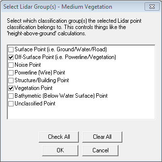
Each Lidar Class can be added to a number of groups that are used for Lidar Automatic Extraction and Lidar statistics like Height Above Ground. These are configured by default to coordinate with the ASPRS classification definitions, but can be customized for other classification schemes.
- Surface - any classes that can be considered surface, like ground, water, road, etc. This group is used in determining Height Above Ground.
- Off-Surface - any classes that definitely aren't on the surface (i.e. powerlines, bridge, noise)
- Noise - which classes are noise classes, to be ignored for most things
- Powerlines - which classes are powerlines. This group is used in Automatic Feature Extraction of Powerlines.
- Structure - which classes are structures, like buildings
- Vegetation - which classes are vegetation
- Bathymetric - which classes are below the water surface