The advanced filtering options for lidar create a subset of points by keeping or removing points based on their attribute values. The advanced filtering of lidar data can be applied from the Digitizer tool, the Lidar/Terrain Display Controls, when exporting, or when running analysis tools on lidar data, such as the Automatic Classification and Feature Extraction tools.
With this digitizer option, the advanced filters are applied to the existing selected lidar, to create a smaller selected subset. When the filter options are set within a analysis tool, it will limit the points that are considered by the tool.
|
|
This tool requires Global Mapper Pro |
To access this option from the Digitizer, select a set of Lidar Points, then right-click with the digitizer and under Advanced Selection Options choose the option to Filter Selected Lidar Points By Elev/Color/Class etc...
The advanced lidar filtering options are also available while running lidar tools, including Create Elevation Grid, Automatic Classification tools, Extract Vector Features and Lidar LAS/LAZ Export Options by choosing the Filter Points..., Filter Points by Elev/Class/etc..., or Filter Lidar Points to Use by Elevation/Class/Color/Etc... buttons.
The Filter Lidar Points dialog (below) contains options to filter lidar points by elevation, height above ground, color, classification, return type, point source ID, scan angle, and NDVI or NDWI if colored by raster calculation results, and classification flags.
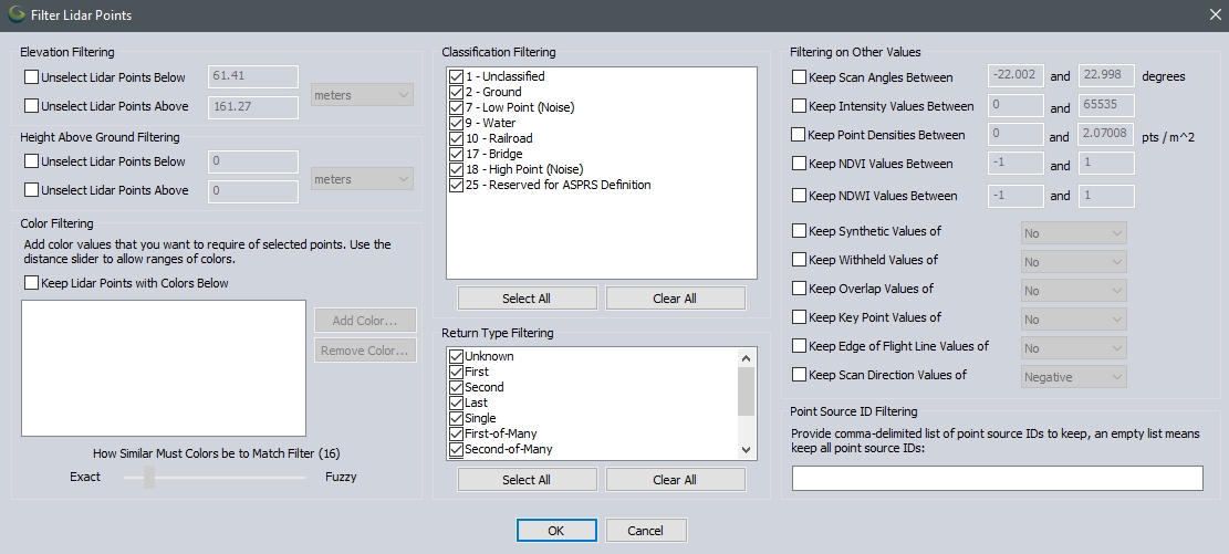
The dialog provides various options to selectively keep or to remove (unselect) points based on their properties.
Note: Within the automated lidar classification tools, it is sometimes necessary to keep points that may not be classified, but are important reference. For example, with tree classification, ground points should not be excluded using the advanced filtering options. The ground points are an important reference in the algorithm for determining what points might be part of a tree.
Elevation Filtering
These options allow filtering or unselecting lidar points based on elevation.
Height Above Ground Filtering
These options allow filtering or unselecting lidar points based on Height Above Ground.
Color Filtering
This option allows for selecting lidar Points based on RGB values. Add a color and use the slider to determine how similar colors must be to be included in the Filter.
Classification Filtering
Filter or unselect lidar points by unchecking Classes.
Point Source ID Filtering
Select Lidar points based on Point Source ID. Point Source IDs identify the flight used when collecting the Data.
Return Type Filtering
Filter or unselect Lidar points by unchecking Return Types.
Filtering on Other Values
Scan Angle
Filter by the acceptable scan angle specified in the point attributes.
Intensity
Filter by the intensity value of the point features. The intensity value comes from the strength of the return signal, and helps to identify differences in surface textures similar to bands of color imagery.
Point Density
Filter data based on the calculated point density. This is calculated on load based on other points in the layer.
NDVI
If the points have Red and IR (Infrared) values associated with them, they may be filtered by NDVI value. Normalized Difference Vegetation Index values range from -1 to 1. For more information see NDVI.
NDWI
Filter by NDWI values. This uses the Green and NIR channels to identify water in water bodies. For more information see NDWI.
Classification Flags
Filter by the Classification Flags that is set from the Classification Flags tab of the Lidar/Terrain Display Controls toolbar button or from the Classification Flags tab in the Configuration menu. For example, if you have selected lidar with any of the following values listed below and you check the box next to "Keep Classification Flag Value of" and set the drop down to Yes, and then click OK, only those lidar points with the values will remain selected.
Classification Flag values
Synthetic values
Withheld values
Overlap values
Key Point values
Edge of Flight Line values
Scan Direction values