DGN
Load DGN
Global Mapper can load DGN files of v8 and later. The color / style, feature description, name, and DGN level will be derived from the file. To see sublayers in the file, see Split Into Separate Layers Based on Attribute Value using the DGN_LEVEL attribute.
Export DGN
The Export DGN command allows the user to export any loaded vector data to a MicroStation DGN v8 format file.
The Export DGN command can be accessed through File>Export Vector/Lidar Format...Select Export Format. Individual layers can also be exported from the Control Center by right-click on the layer and going to Layer > EXPORT. Multiple files can be batch converted to and from the format from the Batch Convert/Reproject tool.
When selected, the command displays the DGN Export Options dialog (pictured below) which allows the user to set up the export. The dialog consists of a DGN Options panel, a Tiling panel, and an Export Bounds panel which allows the user to set up the portion of the loaded vector data they wish to export.
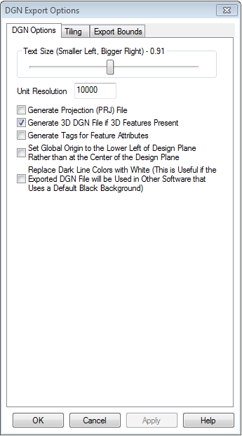
Text Size section
Allows the user to control how large display label text will be in the created file.
Unit Resolution
Value is used to specify the resolution unit saved in the DGN file.
Generate PRJ File
A .prj projection file describing the projection of the coordinates in the file will automatically be created.
Generate 3D DGN File if 3D Features Present
The entire DGN file will be marked as 3D and any features that have a elevation data associated with them will be stored as 3D features.
Generate Tags for Feature Attributes
Any attributes associated with exported features will be saved as tags in the resulting file.
Note: This can significantly slow down export time in some cases.
Set Global Origin to the Lower Left of Design Plane Rather than the Center of the Design Plane:
The global origin is set to the minimum valid negative values rather than at (0,0) as is standard.
Replace Dark Line Colors with White:
Any lines that are near black in color will be replaced with a white line automatically. This is useful for getting dark colored lines to show up when the exported DGN file is viewed in an application that uses a black background.
Tiling
Export Bounds
Format Updates
Below is a summary of recent changes to DGN format support:
| 22.1 | A fixed height instead of a font size for text will be used for export if one has been specified in the workspace. |
| 20.0.0 | Import "property list" attributes from DGN files. |
| 19.0.3 | Updated DGN import to allow elevation unit selection on the projection dialog and use the same behavior as other vector formats when the projection is known without having to prompt the user (i.e. elevation units default to horizontal units if linear). |
| 18.0.0 | Updated import of DGN v8 files with 3D lines (i.e. lines with per-vertex elevations) to use an ELEVATION attribute for any lines with per-vertex elevations that all have the same value (like contour lines). |
| 17.1.0 | Made 3D text imported from DGN files keep the elevation. |
| 16.1.0 | Support DGN files with 3D holes/islands in 3D area features. Previously the per-vertex elevations for the holes were not being used. |
| 15.2.0 | Automatically load additional models in DGN files if the active model is empty. |
| 15.0.0 | Support exporting Lidar point cloud data to DGN and PDF files. |
| 15.0.0 | Updated DGN export to write point features out as 0-dimensional line features rather than create shared cells for each point. |
| 11.2.0 | Made DGN exports that have other DGN files as the source data maintain the level numbers and names on export to the new DGN file if possible. |
| 10.2.0 | Added support for rotated text from DGN v8 files. |
| 10.1.0 | Added LEVEL_DESC attribute to features imported from DGN v8 and later files if the file contains a text description for the level of the feature. |
| 9.2.0 | [Scripting] Added new DGN_GLOBAL_ORIGIN_LL, DGN_REPLACE_DARK_COLORS, and DGN_UNIT_RESOLUTION parameters to the EXPORT_VECTOR script command to allow specifying additional options for DGN export. |
| 9.1.0 | Added option to have cells from DGN v8 and later files to be imported as point features at the cell's origin rather than be exploded into the features referenced by the cell. This option is in the Advanced section of the General Options tab of the Configuration dialog. |
| 9.1.0 | Added option to have the color number for lines from DGN v8 and later files to be add to the feature description text in addition to the level number. This option is in the Advanced section of the General Options tab of the Configuration dialog. |
| 9.1.0 | Added attributes for database linkages to loaded DGN files. |
| 8.0.0 | Added option when batch converting to DGN format to control whether or not 3D DGN files are created. |
| 7.4.0 | Allowed batch conversion of vector data to DGN format files. |
| 7.4.0 | Allowed export of DGN format files from Global Mapper scripts using the EXPORT_VECTOR command. |
| 7.3.0 | Added support for loading DGN v8 and later format files. |