DEM and CDED
Import DEM / CDED
USGS DEM files contain elevations in a regular grid, derived from USGS topographic map contours or directly from aerial photography.
The CDED consists of an ordered array of ground elevations at regularly spaced intervals. It is based on National Topographic System (NTS) maps at the 1:250,000 scale. Nearly complete coverage of Canada is available. CDED data use the same physical format as USGS DEM data, and therefore can be displayed by Global Mapper.
Load these files directly with the following recognized extensions: *.dem; *.dem.gz; *.dat; *.gz; *.1; *.2
Import support is also available for CTM DEM (*.dem), ENVI DEM (*.dat; *.envi; *.hdr), GTOPO30 (gt30*.dem) DHM Swiss DEM (*mbl, *.mlt), GSD Swedish DEM (*.gsd), Helava DEM (*.dte), Japanese DEM (*.mem; *.lem; *.mem.gz; *.lem.gz), MicroDEM DEM (*.dem), Swedish DEM (*.dat), and other related DEM formats.
Export DEM / CDED
The Export DEM command allows the user to export any loaded elevation grid data sets to a native format USGS DEM file.
Export DEM or CDED files from the File> Export menu by choosing Export Elevation Grid Format... or Export Raster/ Image Format.... and specifying DEM or USGS DEM as the Export Format. Individual layers can also be exported from the Control Center by right-click on the layer and going to Layer > EXPORT. Multiple files can be batch converted to and from the format from the Batch Convert/Reproject tool.
When selected, the command displays the DEM Export Options dialog which allows the user to setup the export. The dialog consists of a General options panel which allows the user to set up the quadrangle name, grid spacing and vertical units.
Note: Global Mapper will export a DEM or CDED file in any supported projection. To generate a USGS compliant DEM, make sure the display projection is set to the appropriate geographic, UTM or State Plane projection and datum.
Quadrangle Name
A descriptive name identifying the map. This is typically named by a local physical feature.
Vertical Units
Select from the following options:
- Meters
- Decimeters
- Centimeters
- Millimeters
- Feet
- Decifeet
- Inches
- Centifeet
- Millifeet
Note: DEM files store elevation values as integers. To maintain precision in the output file, specify a small vertical unit, such as Centifeet, Millimeters, etc.
- Nearest Neighbor - simply uses the value of the sample/pixel that a sample location is in. When resampling an image this can result in a stair-step effect, but will maintain exactly the original color values of the source image.
- Bilinear Interpolation - determines the value of a new pixel based on a weighted average of the 4 pixels in the nearest 2 x 2 neighborhood of the pixel in the original image. The averaging has an anti-aliasing effect and therefore produces relatively smooth edges with less stair-step effect.
- Bicubic Interpolation - a more sophisticated method that produces smoother edges than bilinear interpolation. Here, a new pixel is a bicubic function using 16 pixels in the nearest 4 x 4 neighborhood of the pixel in the original image. This is the method most commonly used by image editing software, printer drivers, and many digital cameras for resampling images.
- Box Average (2x2, 3x3, 4x4, 5x5, 6x6, 7x7, 8x8, and 9x9) - the box average methods simply find the average values of the nearest 4 (for 2x2), 9 (for 3x3), 16 (for 4x4), 25 (for 5x5), 49 (for 7x7), 64 (for 8x8), or 81 (for 9x9) ) pixels and use that as the value of the sample location. These methods are very good for resampling data at lower resolutions. The lower the resolution of your export is as compared to the original, the larger "box" size you should use.
- Filter/Noise/Median (2x2, 3x3, 4x4, 5x5, 6x6, 7x7, 8x8, and 9x9) - the Filter/Noise/Median methods simply find the median values of the nearest 4 (for 2x2), 9 (for 3x3), 16 (for 4x4), 25 (for 5x5), 49 (for 7x7), 64 (for 8x8), or 81 (for 9x9) pixels and use that as the value of the sample location. This resampling function is useful for noisy rasters, so outlier pixels do not contribute to the kernel value. Some common sources of raster noise are previous compression artifacts or irregularities of a scanned map/image.
- Box Maximum (2x2, 3x3, 4x4, 5x5, 6x6, 7x7, 8x8, and 9x9) - the box maximum methods simply find the maximum value of the nearest 4 (for 2x2), 9 (for 3x3), 16 (for 4x4), 25 (for 5x5), 49 (for 7x7), 64 (for 8x8), or 81 (for 9x9) pixels and use that as the value of the sample location. These methods are very good for resampling elevation data at lower resolutions so that the new terrain surface has the maximum elevation value rather than the average (good for terrain avoidance). The lower the resolution of the export file is as compared to the original, the larger "box" size that should be used.
- Box Minimum (2x2, 3x3, 4x4, 5x5, 6x6, 7x7, 8x8, and 9x9) - the box minimum methods simply find the minimum value of the nearest 4 (for 2x2), 9 (for 3x3), 16 (for 4x4), 25 (for 5x5), 49 (for 7x7), 64 (for 8x8), or 81 (for 9x9) pixels and use that as the value of the sample location. These methods are very good for resampling elevation data at lower resolutions so that the new terrain surface has the minimum elevation value rather than the average. The lower the resolution of the export file is as compared to the original, the larger "box" size that should be used.
- Gaussian Blur (3x3, 5x5, 7x7) - the Gaussian blur methods calculate the value to be displayed for each pixel based on the nearest 9 (for 3x3), 25 (for 5x5), or 49 (for 7x7) pixels. The calculated value uses the Gaussian formula that weights the values based on the distance to the reference pixel.
The Sample Spacing section allows the user to select the grid spacing to use when generating the file. The default value is the average of the grid spacings of all the currently loaded raster and elevation overlays.
If the Always Generate Square Pixels option is checked, the smaller of the specified x and y resolutions will be used for both the x and y resolution.
Selecting Always Generate Square Pixels ensures that the resultant image file will look good even in software that is not able to deal with pixels that aren't square.
To specify the spacing in units other than those of the currently selected view/ export projection, press the Click Here to Calculate Spacing in Other Units button.
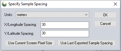
Specify the X and Y spacing of the output pixels in any of the selected units. These pixel dimensions will be translated into the units of the display projection during export. The Use Current Screen Pixel Size button will update the X and Y values to the dimensions of the map display. Use Last Exported Sample Spacing will update the X and Y values to the most recent export resolution.
Format Updates
| 19.1 | Improved support for import and export of USGS DEM with International Feet as the units for a State Plane projection.[Item #20175] |
| 16.0 | Added a Graph and Chart Manager under the Analysis menu to allow creating graphs and charts from loaded data., including histograms for gridded terrain layers (i.e. DEMs) |
| 12.2 | Added support for ENVI DEM files with 32-bit integer samples. |
| 8.3 | Make default export elevation units for DEM and Global Mapper Grid exports be decimeters if metric units are the default so that the full precision of nearly all data sets will be preserved by default. |
| 7.4 | Added support for loading Japanese DEM (JDEM) .mem files. |
| 7.3 | Made the filling in of small gaps work when exporting DEM files with arc degrees as the current view/export units on the Projection tab of the Configuration dialog. |
| 7.2 | Added option to write an invalid datum code to DEM files when exporting with a view/export datum set to one that is not supported by the DEM format. |
| 7.0 | Manually compute the min/max sample values for USGS DEMs that have a non-unity Z resolution since they are often stored incorrectly, resulting in odd shading in Global Mapper. This will apply to things like decimeter and centimeter DEMs. |