Import CSV
CSV files that contain coordinates can be opened using the Open Generic Text File option in the File Menu. They may also be opened with the open data options, which will provide the same Generic Text File Import Options dialog.
Some special CSV files will load automatically without displaying the import dialog, such as USGS EarthExplorer CSV Coverage files.
CSV files that do not contain coordinates can be appended to related vector features by Joining a Table.
Export CSV
The Export CSV command allows the user to export any loaded point data sets to a CSV (Comma Separated File) file. Area and line features may also be included in the export based on an additional option.
Export loaded vector data to a csv file from the File > Export > Export Vector/Lidar Format... option, or by right-clicking on a specific layer in the Control Center going to Layer > EXPORT and choosing CSV as the export format. Multiple files can be batch converted to and from the format from the Batch Convert/Reproject tool.
CSV files can also be exported from within a subset of tools, including just the attribute values from the Attribute Editor, profile values from the Path Profile tool, and additional reports. ![]() Search Index
Search Index
See also additional information on text based formats ![]() See Also
See Also
When selected, the command displays the CSV Export Options dialog which allows the user to set up the export.
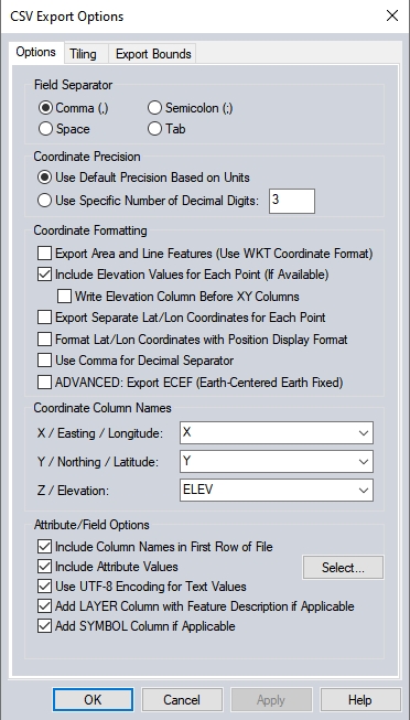
The CSV export options are grouped in to various categories of settings that control the output data and formatting of the generated CSV file.
Field Separator
Specify the delimiter used to separate values in the output file. Note that per the default extension .csv, this would typically be comma separated. The extension could however be customized during file naming in the subsequent dialog.
Coordinate Precision
Use the default coordinate precision, which is typically 3 decimal places for planar units, or specify an explicit decimal precision for the output coordinates.
Coordinate Formatting
Export Area and Line Features (Use WKT Coordinate Format)
The default csv export will only include point features. Check this option to also include areas and line features.
Examples of WKT formatted coordinates![]()
Include Elevation Values for Each Point (If Available)
Check this option to include elevation values as a coordinate value points that contain them.
Write Elevation Column Before XY Column
Check this option to make elevation the first value in the file.
Export Separate Lat/Lon Coordinates for Each Point
Enabling this option will include LATITUDE and LONGITUDE columns in addition to X and Y when the projection is not Geographic.
Format Lat/Lon Coordinates with Position Display Format
LATITUDE and LONGITUDE attributes (when being included) will use the current Position Display Format setting in Measure/ Units Configuration for formatting those values.
Use Comma for Decimal Separator
This setting will use a comma as the decimal separator for coordinates, rather than a period.
ADVANCED: Export ECEF (Earth-Centered Earth Fixed)
Check this option to export X and Y values as ECEF.
Export MGRS String for Each Point
Check this option to include a 1-meter precision level Military Grid Reference System string for each point. MGRS is a NATO coordinate system which references points by UTM grid zone, then 100,000 meter square identifiers, then numerical easting and northing.
Coordinate Column Names
The names of the coordinate values will populate from the loaded data being exported. Type a new name to modify the column names for the exported coordinates.
Attribute/ Field Options
Include Column Names in First Row of File
This is enabled by default. This will include a label header row in the first row of the file that identifies the subsequent values. This comes from the attribute names, or the column names otherwise designated on the dialog.
Include Attribute Values
If this is not checked, only coordinate and label values will be exported. When checked, selected attribute values will be included in the export, even if all of the attribute values are blank. The default is for all attribute values to be included. Press the Select... button to choose a subset of attributes to include.
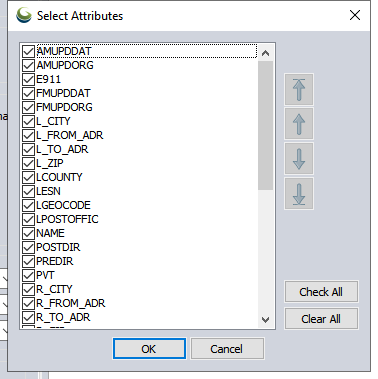
Press the Check All or Clear All buttons to bulk select or deselect attributes. Use the arrow buttons to change the order of attributes in the exported file. The arrow with the underline will move the highlighted attribute to the bottom or top of the list.
Use UTF-8 Encoding for Text Values
When this option is not checked, the character encoding defaults to ANSI. Check this option to encode the characters in UTF-8. This provides support for additional language characters.
Add LAYER Column with Feature Description if Applicable
Check this option to include a value in each row listing the layer name the feature is contained in.
Add SYMBOL Column if Applicable
Enable this option to include a SYMBOL value in each row that specifies the name of the symbol used to symbolize the feature in Global Mapper. Global Mapper will automatically recognize this value when reloading the file. For more information see Special Attributes & ASCII Field Options
Add Formatted UTM-K Coordinate Column
Check this option to include coordinates in the UTM-K format used in South Korea. They are rounded to the nearest 10 meters and have an X and Y Korean character at the start of the coordinate specifying the UTM-K X and Y zones.
Format Updates
Below is a summary of recent changes to CSV format support:
| 21.1 | Specify which attributes to include and attribute order when exporting to CSV, text and vector XYZ files. [Item #GM-10745] |
| 21.1 | When using the Finding Nearby Points tool, there is now an option to save the points as an ESRI shapefile as well as a .csv, or .txt file. [Item #GM-10289] |
| 20.1 | (Scripting) Allow the specification of the CODE_PAGE parameter when exporting to CSV files using the EXPORT_VECTOR script command.[Item #25482] |
| 20.1 | Added option to CSV export to allow the use of UTF-8 encoding for the output text.[Item #25482] |
| 20.1 | Improved precision of Z coordinates when exporting with ECEF coordinates to CSV files.[Item #25718] |
| 18.2 | Added support for loading USGS National Map Coverage CSV files. [Item #19586] |
| 18.0 | Now allows exporting CSV files with the Y/latitude coordinate before the X/longitude coordinate when batch converting. [Item #18201] |
| 18.0 | New option to export CSV files with the Y/latitude coordinate before the X/longitude coordinate. Use COORD_ORDER=Y_FIRST in the EXPORT_VECTOR command to do this. [Item #18201] |
| 17.1 | Can now export attribute search results to a CSV file |
| 17.1 | Added option to save selected result items to a CSV / Excel file on the Search dialog. [Item #17026] |
| 17.0 | Save N/A in saved CSV when no surface elevations are present rather than -999999.0 meters (or feet version). [Item #15846] |
| 17.0 | Added support for new USGS EarthExplorer coverage CSV files with comma delimiters. [Item #15992] |
| 16.2 | When loading CSV files with a NAME or LABEL attribute, or just a single un-recognized attribute per feature, assign the layer to automatically use that attribute for the label rather than copying to the feature label and removing the original attribute. [Item #15380] |
| 16.1 | Added the 3D segment and total distance to a CSV file for a 3D path saved from the File menu on the Path Profile/LOS dialog. |
| 15.2 | Add Tiling tab to CSV export to allow gridding into tiles. |
| 15.2 | Made CSV export from path profile start the distances at the specified base distance. |
| 15.2 | Updated the saving of a CSV file from the path profile dialog to save the elevation from each terrain surface as separate column if you have the option enabled to display a separate line for each surface and there were multiple surfaces under the path. |
| 15.2 | Added support for exporting point data to Lowrance SonarLog (SLG) CSV files. |
| 15.2 | Added option to write out ECEF coordinates when exporting to CSV and Simple ASCII Text format. |
| 15.2 | Updated the batch geo-coder to recognize PROVINCE and POSTAL CODE as column names from a CSV/text file being geo-coded. |
| 15.1 | Added option to use WKT formatting and includes area and line features when batch converting to CSV format files. |
| 15.0 | (Scripting) Added support for exporting area and line features to CSV files with EXPORT_VECTOR by adding POINTS_ONLY=NO as a parameter. |
| 15.0 | Made area groups be supported for import from and export to CSV files with WKT coordinate strings and MULTIPOLYGON objects. |
| 14.2 | Updated CSV export to have option to specify the digits of precision, allow use of spaces or semi-colons as separators, write the ELEV field first, and to allow using commas for decimals rather than periods (i.e. European style). |